L'Alzou depuis le belvédère de l'Oppidum. Traditional Cache
L'Alzou depuis le belvédère de l'Oppidum.
-
Difficulty:
-

-
Terrain:
-

Size:  (regular)
Please note Use of geocaching.com services is subject to the terms and conditions
in our disclaimer.
[FRANCAIS] Cette cache, surplombant le moulin de Tournefeuille, est située à mi-circuit... et quel circuit!. Ici, temps de repos bienvenu. On souffle un peu. On en redemande.
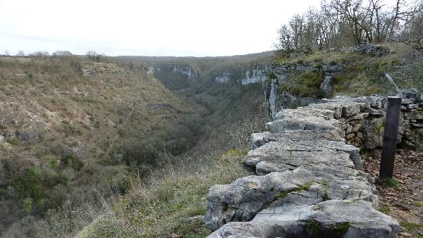
Concernant l'Oppidum, il est peut-être lié à la lutte des Gaulois contre les troupes de César. Il a pu servir de point de surveillance de la vallée de l'Alzou (pré-celtique = eau) et de la voie romaine Limoges-Rodez passant de l'autre côté de la vallée, à Roumégouse (château).
Le plateau de Saint-Cyr aurait vu naître le troubadour Uc de Saint-Circ (XII ième - XIII ième). Voir: "Saint-Cyr sur Alzou" - "la Grange de Saint-Cyr - "promontoire de Saint-Cyr".
La cache est une boîte cylindrique en plastique de 15x6cm. Elle contient le logbook mais pas de crayon.
A ce jour, 5 caches, dont celles de moonray83, sont à découvrir sur le parcours.
Boucle d'environ 4,5km, PK-moulin de Tournefeuille-PK, autour de l'Alzou.
Deux possibilités:
- Par le bas: GR6 à descendre. Passer le pont. Prendre à gauche, rive droite, et longer l'Alzou jusqu'au moulin du Saut. Puis continuer vers le moulin de Tournefeuille. Là, traverser le pont et monter. En arrivant en haut (plateau de Saint-Cyr), prendre à gauche vers la cache et poursuivre vers le PK.
- Par le haut: suivre le sentier passant à travers le bois jouxtant le PK.Longer les falaises (veiller sur les enfants). Après la cache, descendre à droite jusqu'au moulin de Tournefeuille. Le pont franchi, prendre à droite le chemin remontant l'Alzou. Après le moulin du Saut, passer le pont et "go" (GR6) vers le PK juste en haut de la côte.
Bonne promenade et bonne chance!
[ENGLISH] The cache, a 12x9x7cm plastic box, is situated above the "Moulin de Tournefeuille". There, you are about half-way of a beautiful circuit. Have a rest, look over the Alzou valley (Alzou = eau) and go on...
L'Oppidum knew perhaps fights between Gaulois and roman Legions. It was possible to watch over the "Limoges-Rodez" roman way at Roumégouse, just in front of the place.
Native of "plateau de Saint-Cyr" (promontory where is the cache), the troubadour Uc de Saint-Circ (XII-XIIIth) was famous during the Middle Ages.
Circuit: PK-Moulin de Tournefeuille-PK round the Alzou river. About 4.5km. Five caches to find at the present time with the boxes of moonray83.
Two possibilities:
- From the PK, go down to the river (GR6). Cross the bridge. Turn left and take the path, right bank, along the Alzou river to "Moulin du Saut" and, next, always along Alzou, to "Moulin de Tournefeuille". There, cross the bridge and go up. At the top (plateau de Saint-Cyr), turn left to the cache and continue along the cliffs to the PK (watch over kids).
- From the PK, take the path at the same level crossing the nearby wood and walk, always along the cliffs (watch over kids), to the cache. Next, turn right and go down. Cross the bridge. Turn right to "Moulin de Tournefeuille". Take the path along the river to "Moulin du Saut". Continue, always along the Alzou river. Cross the bridge and go up (GR6) to the PK.
Enjoy and good luck!
Additional Hints
(Decrypt)
Qnaf ha ebpure, 2z à tnhpur qh purzva, qreevèer ha neohfgr, fbhf qr yn zbhffr rg qrf cvreerf.
Vafvqr n ebpx, 2z ra yrsg bs gur cngu, ba gur onpx bs n fznyy gerr, haqre fgbarf naq zbff