|
THE GANNET COLONY
The gannet, or takapu, colony that resides here is significant as it is one of only three colonies on the mainland of New Zealand. The gannets first began nesting on Motutara Island in 1975 when their original home of Oaia Island (visible to the south west) became overcrowded.
The invasion of the gannets displaced the previous residents of the island, white-fronted terns, which were then forced to nest in small crevices on the sheer cliff faces. In 1979, due to further increases in numbers of the gannets, the colony expanded to the mainland, with birds nesting on the southern point, in front of the viewing platform at the published coordinates.
The gannets have taken advantage of this site, with it's geological significance, due to the almost ever present wind and the uplift caused from the wind action on the cliffs. From a young age, the gannets live on the edge of the wind using the strong updrafts for easy takeoff. At just 15 weeks old they will leave the nest only to return here in 3 years time. Each year birds return to this spot after their migratory journey to Australia and back.
The Auckland Regional Parks Service, with the help of the Royal Forest and Bird protection Society, established the area as the Takapu Refuge and bestowed upon it some protection against dangers to the new habitat - mainly from dogs and humans. As numbers of the gannets continued to climb, unpaired birds began to take over the northern point with nesting beginning a few years later.
Continued overcrowding in the expanding colony is now forcing some birds to explore further up the slopes and into the grass areas. It is envisaged that the fences, viewing platforms and paths may have to be moved back away from the birds to allow for unhindered expansion at some point in the future.
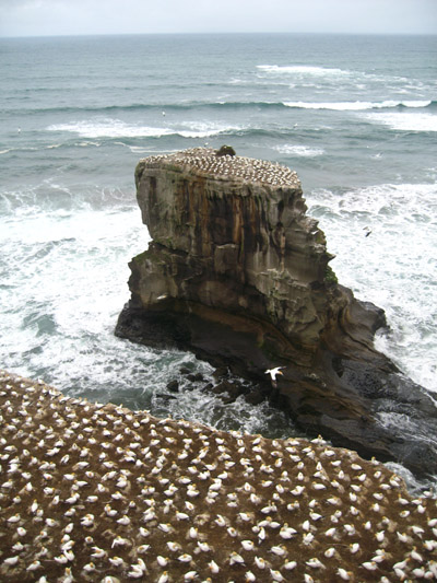
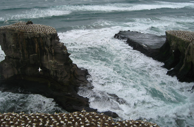
MOTUTARA ISLAND
Motutara Island is a site of geological significance where one can observe a classic sea stack (the island itself). Unlike many sea stacks, this one was created by two sea caves that independently formed on a collision course eventually forming one large arched sea cave that bent sharply around behind the island. The two caves each formed quite geometrically with sharp sheer and quite straight cliff faces, and their directions can be fairly precisely determined with the use of a compass.
The cliffs comprising the coastline here consist of sedimentary rock supported on a base of harder limestone. Hydraulic action on the cliffs erodes away the sedimentary rock quicker than the limestone, exposing such features as Fisherman's Rock, the large shore platform extending south west from the end of Muriwai Beach.
As the waves pound against the cliffs, the pressure forces air into cracks and fissures in the rock face. When the wave subsequently retreats, the air expands explosively. Cracks grow and propogate and over time chunks of rock dislodge, adding to the abrasive power of the waves.
Eventually the arched roof of the large sea cave eroded and collapsed leaving the sea stack now known as Motutara Island and home to the northern-most gannet colony on New Zealand's mainland.
THIS EARTHCACHE
This earthcache will take you to a viewing platform overlooking the Motutara Island sea stack. In order to log the earthcache you will need to perform a couple of simple tasks to prove you visited the location and that you have learnt something about the geology of the island and how it was formed.
You will need to contact the cache owner and supply the answers to the questions below, and to take a photograph, also specified below, at the site and upload it with your online log. Do not include the answers to the questions in your online log. Do not attempt this cache at night as you will not be able to see anything, which means you won't be able to answer the required questions or take a photo. Failure to provide the answers to the cache owner, or to upload the required photo, may result in your online log being deleted.
1. Using your GPS to take an altitude reading, estimate the height of the sea stack in metres.
2. By observation work out the approximate directions (to the nearest 10 degrees true) in which the two sea caves must have eroded in order to form the sea stack. You MUST answer this question, and simply stating that you do not understand the question is NOT an acceptable answer.
3. Take a photo that includes yourself with your GPS unit, and Motutara Island (the sea stack) in the background. Upload this photo with your online log.
You can log this cache straight away after you have emailed your answers to the cache owner, no need to wait for confirmation. Please include the name of this earthcache in the email - you'd be surprised how many people forget. Also, when contacting us with answers, if you want a reply, please include your email address. Any problems with your answers we'll be in touch.
Happy Earthcaching!
|