Die Grabfeld-Formation EarthCache
-
Difficulty:
-

-
Terrain:
-

Size:  (other)
Please note Use of geocaching.com services is subject to the terms and conditions
in our disclaimer.
Die Grabfeld-Formation
Die Grabfeld-Formation ist eine lithostratigraphische Formation des Mittleren Keupers in der Germanischen Trias und ist datiert in den Zeitraum vor etwa 232,5 bis 229 Millionen Jahren.
Seit einigen Jahren werden die traditionellen Namen der Triasschichten in Mitteleuropa dem international üblichen Standard angepasst. Der untere Teil des Gipskeupers, also die traditionellen Myophorien- und Estherienschichten Süddeutschlands, wurden in diesem Prozess zur Grabfeld-Formation umbenannt. Der Aufschluss stellt eine Typuslokalität der Grabfeld-Formation dar, nach der alle gleichartigen Gesteinsschichten in Europa benannt sind.
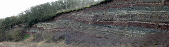
Der Aufschluss zeigt den oberen Teil der Myophorienschichten, die sogenannten Rotvioletten Tonsteine, mit einer wechselhaften Abfolge von Ton- und Silitsteinen, Tonmergel, Dolomitsteinen und auch dünnen Kalk- und Gipslagen.
Beim Betrachten der Schichten erkennt man zunächst den Wechsel der Gesteinsfarben von rot über violett, grau, grünlich oder olivbraun und weißlich. Beim genaueren Hinsehen lässt sich ein Schema feststellen: Man erkennt rhythmische Abfolgen von blauviolett über rotviolett nach rot und rotbraun. Die rhythmischen Wechsel dokumentieren die Veränderungen des Ablagerungsraums und der Oxidation beziehungsweise Reduktion der Schlämme an dieser Stelle zur Enstehungszeit der Sedimente in einer sogenannten Playa - einer episodisch überfluteten Senke, in der Schlammsedimente gebildet wurden und ab und zu große Seen existierten und wieder verdunsteten.
Dazwischen gibt es Schichten, in denen eine Bodenbildungen stattgefunden hat; diese sind durch die charakteristische Violettfärbung zu erkennen, in der ab und zu auch noch versteinerte Wurzelröhren von damaligen Pflanzen zu finden sind.
Logbedingungen:
Mach bitte ein Bild von dir an der Infotafel und beantworte folgende Fragen:
- Aus welchen Gesteinsarten bestehen die graugrünen Schichten im Aufschluss? (siehe Bild auf der Infotafel)
- Schätze die Höhe des Aufschlusses und berechne daraus den durchschnittlichen Zeitraum, in dem 1cm abgelagert wurde. Zur Berechnung nehmen wir an, dass der komplette Aufschluss innerhalb von 125.000 Jahren abgelagert wurde. (Formel zur Berechnung: 125.000 Jahre/geschätzte Höhe in cm)
Schicke die Antworten per Mail an mich (bitte mit Angabe des Cache-Namens, wir sind Owner mehrerer Earthcaches).
Es ist nicht nötig, auf die Logfreigabe zu warten, bei falschen Antworten melden wir uns. Es wäre schön, ein Foto in den Log einzufügen.
Logs ohne Antwortmail an den Owner werden gelöscht!
Weitere Informationen findet ihr bei Wikipedia
The 'Grabfeld'-formation
The 'Grabfeld'-formation is a lithostratigraphic unit of the middle Keuper in the German Triassic and it is dated within the Ladinian and Carnian.
Since some years the traditional names of the Triassic formations in Central Europe are adapted to the international standard. Therefore the lower part of the 'Gipskeuper', the traditional 'Myophorien' and 'Estherien'-formations of South Germany, were renamed during this process to the 'Grabfeld'-formation. The outcrop represents a type locality of the 'Grabfeld'-formation, after which all congeneric rock formations are named in Europe.
The outcrop shows the top of the 'Myophorien'-formation, the so-called red-violet clay stones, with a changeful sequence of clay and silicon carbide, marl, dolomite rocks and also thin layers of lime and gypsum. If you look at the layers you recognize first the change of the rock color from red over violet, grey, greenish or olive-brown and white. When you look more precisely a pattern can be determined: You recognize rythmic sequences from blue-violet over red-violet to red and red-brown. The rhythmic alternations are documenting the changes within the deposit area and the oxidation respectively reduction of the sludge during the date of origin of the sediments in a so-called 'Playa'. A 'Playa' is a episodically flooded sink, where sludge sediments were build and from time to time large seas originated and evaporated again.
Between are layers in which soil development took place, they can be recognized by the characteristic violet color, in this layers from time to time fossil root tubes from plants can be found.
Log conditions:
To log the cache please take a picture of you at the information board and answer the following questions:
- Of which kind of rocks do the grey-green layers consist in the outcrop? (see picture on the information board)
- Estimate the height of the outcrop and calculate from it the average period in which 1 centimeter was deposited. For the calculation you can assume that the complete outcrop was deposited within 125000 years. (125000 years/estimated height in centimeters)
Send the answers via mail to me.
After receipt of the log release please place your photo also into the log.
Logs without log release will be deleted.
Additional Hints
(No hints available.)