Pyramids of Meroe -
Sudan
Nubian
Pyramids:
The area of the Nile valley known as Nubia that
lies within present day Sudan was home to three Kushite kingdoms
during antiquity: the first with its capital at Kerma
(2600–1520 BC), the second centered on Napata (1000–300
BC) and, finally, the kingdom of Meroe (300 BC–AD 300).
Kerma was Nubia's first centralized state with its own indigenous
forms of architecture and burial customs. The last two kingdoms,
Napata and Meroe, were heavily influenced culturally, economically,
politically, and militarily by the powerful pharaonic Egyptian
empire to the north. The Kushite kingdoms in turn competed strongly
with Egypt, to the extent that during the late period of Ancient
Egyptian history, the rulers of Napata conquered and unified Egypt
herself, ruling as the pharaos of the Twenty-fifth Dynasty.
The Napatan domination of Egypt was relatively brief it ended with
the Assyrian conquest in 656 BC, but its cultural impact on the
Napatans was enormous, and this coalesced into an extraordinary
burst of pyramid-building activity that was sustained throughout
the existence of Napata's successor kingdom, Meroë.
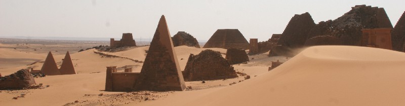
Approximately 220 pyramids were eventually constructed at three
sites in Nubia over a period of a few hundred years to serve as
tombs for the kings and queens of Napata and Meroë. The first of
these was built at the site of el-Kurru, including the tombs of
King Kashta and his son Piye (Piankhi), together with Piye's
successors Shabaka, Shabataka, and Tanwetamani. Fourteen pyramids
were constructed for their queens, several of whom were renowned
warrior queens. This can be compared to approximately 120 pyramids
that were constructed in Ancient Egypt over a period of 3000
years.
Later Napatan pyramids were sited at Nuri, on the west bank of the
Nile in Upper Nubia. This necropolis was the burial place of 21
kings and 52 queens and princes including Anlami and Aspelta. The
bodies of these kings were placed in huge granite sarcophagi.
Aspelta's weighed 15.5 tons, and its lid weighed four tons. The
oldest and largest pyramid at Nuri is that of the Napatan king and
Twenty-fifth Dynasty pharaoh Taharqa.
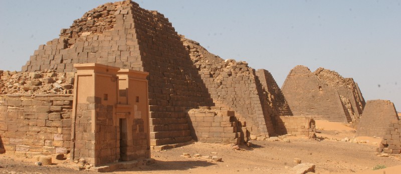
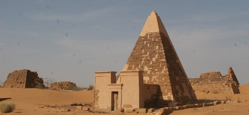
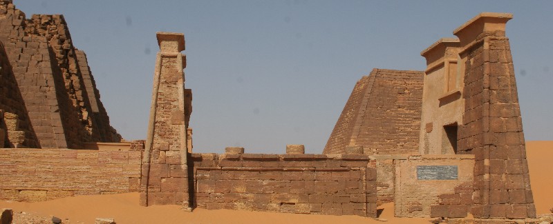
The most extensive Nubian pyramid site is at Meroë,
which is located between the fifth and sixth cataracts of the Nile,
approximately one hundred kilometres north of Khartoum. During the
Meroitic period, over forty queens and kings were buried
there.
The physical proportions of Nubian pyramids differ markedly from
the Egyptian difices that influenced them: they are built of
stepped courses of horizontally positioned stone blocks and range
from approximately six to thirty metres in height, but rise from
fairly small foundation footprints that rarely exceed eight metres
in width, resulting in tall, narrow structures inclined at
approximately seventy degrees. Most also have small
Egyptian-inspired offering temple structures abutting their base.
By comparison, Egyptian pyramids of similar height generally had
foundation footprints that were at least five times larger and were
inclined at angles of between forty and fifty degrees.
All of the pyramid tombs of Nubia were plundered in ancient times,
but wall reliefs preserved in the tomb chapels reveal that their
royal occupants were mummificied, covered with jewellery and laid
to rest in wooden mummy cases. At the time of their exploration by
archaeologists in the nineteenth and twentieth centuries, some
pyramids were found to contain the remains of bows, quivers of
arrows, archers' thumb rings, horse harnesses, wooden boxes,
furniture, pottery, colored glass, metal vessels, and many other
artifacts attesting to extensive Meroitic trade with Egypt and the
Hellenistic world.
A pyramid excavated at Meroë included hundreds of heavy items such
as large blocks adorned with rock art and 390 stones that comprised
the pyramid. A cow buried complete with eye ointment was also
unearthed in the area to be flooded by the Meroë Dam, as were
musical rocks that were tapped to create a melodic sound.
Nubian
Sandstone:
Nubian sandstone ranges in age from the Cambrian to
Upper Cretaceous eras. Positioning of the paleoequator and
paleolatitude at 20° S was derived from paleomagnetic data showing
Nubian sandstone was originally deposited in the paleoequatorial to
subequatorial zone. These paleomagnetic results corroborated
previous studies suggesting there was no polar wandering and
continental drift in Africa during 210 to 110 million years and
extended this period to 85 million years. Nubian sandstone is
deposited under a tropical to subtropical climate and is formed
under a variety of continental conditions, excluding eolian merging
intermittently into shallow marine.
The Nubian sandstone complex has a thickness varying from under 500
m to over 3000 m, resting on the Precambrian basement. This is
complicated by various structural faults and fold axes traversing
the region in a north-eastern direction. Maximum development occurs
in the Ain Dalla basin, a downthrown structural block south-west of
the Bahariya oasis. Basement features present a dominant control on
the complex's structural and sedimentological form. Despite many
structural complications, Nubian sandstone likely constitutes a
single hydrogeological system west of the Suez Gulf. To the east,
on the Sinai peninsula, a second system might exist with some
connection to the primary western system in the north. The main
western system, extending into Libya and Sudan, consists of a
multi-layered artesian basin where massive groundwater reserves
accumulated, principally during pluvials of the Quaternary.
Locally, carbonate rocks overlying the complex display karst
features and are recharged by upwards leaks from the underlying
major aquifer. Fluvial and structural interpretations from 2007
show the desert in western Egypt was induced by fluvial action,
including recently mapped alluvial fans. In central areas, braided
channels are spatially aligned to a north-east structural trend,
suggesting preferential water flow paths. Alluvial fans and
structurally enclosed channels coincided to gentle slopes and
optimal recharge conditions between 1 and 5%, indicating high
groundwater potential. Synthetic Aperture Radar (SAR)
interpretations correlated with anomalies from groundwater in 383
wells, suggesting a connection between the spatial organization of
fluvial and structural features with low-salinity groundwater,
which exists adjacent to alluvial fans and the south-west reaches
of structurally enclosed channels. Wells in the vicinity of
structures contained low-salinity water.
Reference: Wikipedia
To log this Earthcache answers the following
questions by mail:
Exact at the coordinates you get up a small hill.
1. That is not sandstone, which kind of rocks you can discover
here?
2. How many sandstone pyramids do you see from this location?
All other logs will be deleted.
Please upload with your log a picture with you and the GPS in the
hand and the pyramids in the background.