Introduction:
This is our first Earthcache; we hope you enjoy the area as much
as we did. We ventured down the trail to Greeley Pond a few months
ago with Kayak Kouple. It was such a beautiful trail to a small
pond away from everything. Along the trail were some very
interesting erratics that peaked my interest. The trail is
relatively flat but there is one water crossing which might be a
challenge depending how much water is flowing at the time. It is a
well-used trail so be watchful of all the exposed roots. It is
about a mile and a half to the pond one way from the posted parking
coords, but well worth the hike. There is also a $3 parking fee. I
would plan on bringing a lunch with you and enjoy the pond area. It
is very peaceful here.
"Greeley Pond”
Lake and Pond Formation:
Lakes and ponds are formed through a variety of events, including
glacial, tectonic, and volcanic activity. Most lakes and ponds form
as a result of glacial processes. As a glacier retreats, it may
leave behind an uneven surface containing hollows that fill with
water. Glacial activity at the end of the Pleistocene epoch (ten
thousand to twenty thousand years ago) resulted in the formation of
most of the lakes and ponds in the Northern Hemisphere, including
the Great Lakes of North America. Some of the oldest lakes and
ponds (more than three hundred thousand years old) were formed by
tectonic activity related to movement of Earth's crust. For
example, Lake Baikal in Siberia formed from the movement of
tectonic plates and is the largest freshwater lake by volume in the
world. Volcanic activity can also lead to lake and pond formation.
For example, the collapse of a volcanic cone of Mount Mazama in
Oregon led to the formation of Crater Lake, the seventh deepest
lake in the world.
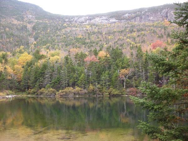
Greeley Pond Scenic Area is about 1 mile from the highway,
featuring two ponds. Upper Greeley Pond, with its dark aqua-green
color, is a beautiful spot, surrounded by old growth timber and
towering cliffs. By contrast, Lower Greeley Pond is shallow and
more typical of a beaver pond. Both ponds offer trout fishing and a
enjoyable place to have a picnic lunch.
Glacial erratic:
Modified from Wikipedia,
A glacial erratic is a piece of rock that differs from the size and
type of rock native to the area in which it rests. "Erratics" take
their name from the latin word "errere", and are carried by glacial
ice, often over distances of hundreds of kilometres. Erratics can
range in size from pebbles to large boulders such as as Big Rock
(16,500 tons) in Alberta. In Madison New Hampshire you can visit
the Madison Boulder Earthcache (see picture) just to compare the
different sizes the erratics may be. Madison Boulder is the largest
known erratic in New England and among the largest in the
world.
Madison Boulder
Earthcache:
Geologists identify erratics by studying the rocks surrounding
the position of the erratic and the composition of the erratic
itself. Erratics are significant because:
- Since they are transported by glaciers, they are one of a
series of indicators which mark the path of prehistoric glacier
movement. Their lithographic origin can be traced to the parent bed
rock, allowing for confirmation of the ice flow route.
- They can be transported by ice-rafting,. This allows
quantification of the extent of glacial flooding resulting from ice
dam failure which release the waters stored in proglacial lakes
such as Lake Missoula. Erratics released by ice-rafts that were
stranded and subsequently melt, dropping their load, allow
characterization of the high water marks for transient floods in
areas like temporary Lake Lewis.
- Erratics dropped by icebergs melting in the ocean can be used
to track Antarctic and Arctic-region glacial movements for periods
prior to record retention. These can be correlated with ocean
temperatures and levels to better understand and calibrate models
of the global climate.
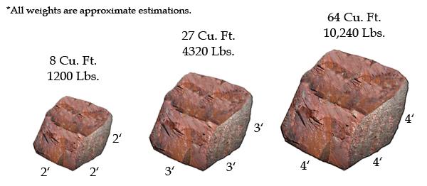
Granite weight calculating:
The average weight of a granite boulder is approximately 168
pounds per cubic foot. To estimate the quantity, you need to
convert the area into cubic feet by multiplying length x width x
height. Once you have this number, multiply it by the boulder's
weight per cubic foot, and then divide by 2000 to convert this
number into tons.
Your Mission:
We have posted waypoints for two of three erratics along the
main trail; you can't miss any of them.
To log this cache you must send us the following information:
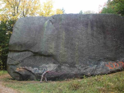
- Send us the coordinates of the first erratic along this trail,
If you are unsure on your way in you won't be on your way out.
- Please also post a picture of your group in front of the first
erratic. (see picture below)
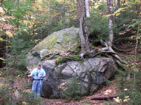
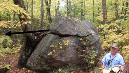
- When you are at the second erratic there is a tree growing on
top.
- Located at N 44 00.980 W 071 30.391
- Send us the compass bearing of which direction the tree is
growing from the center of the erratic. (see picture below)
- At the third erratic send us the estimated weight in pounds or
tons.
- Located at N 44 00.780 W 071 30.426
The tree is growing in that diection.
Take your picture here.