Naturdenkmal "Volzemer Steine"

 Deutsche Version
Die „Volzemer Steine“
sind Blockhalden zwischen dem Dreimarkstein und Dobel. Bis sie 1949
als Naturdenkmal ausgewiesen wurden, nutzte die einheimische
Bevölkerung die Felsen als Steinbruch. Aus dem widerstandsfähigen
Sandstein wurden Mühlsteine und Brunnentröge gefertigt.
Für zahlreiche Dobler Kindern dienten die „Volzemer
Steine“ auch als Abenteuerspielplatz.
Der Große Volzemer Stein (meist
einfach Volzemer Stein genannt) liegt direkt am Westweg (Pforzheim
– Basel). Er ist etwa 100 m breit und bis zu 10 m hoch. Der
Kleine Volzemer Stein liegt etwas abseits des Weges im Wald.
Entstehung:
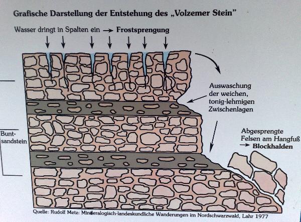
Am „Volzemer Stein“
tritt geschichteter Buntsandstein zutage. Durch Regen und
Sickerwasser werden die weichen, tonig-sandigen Schichten nach und
nach ausgespült. Gleichzeitig sprengt das in Gesteinsritzen
eingesickerte Wasser bei Frost die senkrechten Klüfte immer weiter
auf.
Diesen Vorgang nennt man „Frostsprengung“.
Durch diese Erosionserscheinungen brechen die Blöcke ab und sammeln
sich als Block- oder Schutthalden am Hangfuß.
Um den Cache zu loggen, müsst Ihr folgende Bedingungen
erfüllen:
1. Beantworte nachfolgende Frage:
Dieses Naturgebilde „Volzemer
Steine“ mit den riesigen Sandsteinblöcken ist geologisch
gesehen eine Besonderheit. Worin liegt diese Besonderheit?
Die Antwort hierzu erhaltet Ihr vor Ort.
2. Fertigung eines Lichtbilds
Mache ein Bild welches Dich und im
Hintergrund die „Volzemer Steine“ zeigen. Lade dieses
Bild mit dem Log hoch.
Sende die Antwort mit der Funktion
"send message" an mich und Ihr könnt sofort mit Eurem Foto
loggen.
Es ist nicht notwendig auf eine Logerlaubnis zu warten! Ich behalte
mir jedoch vor, den Log zu löschen falls das Bild nicht dabei ist
oder die Frage falsch beantwortet wurde.
Parkmöglichkeiten bestehen am
Ortseingang von Dobel, Parkplatz „Horntannhalde“.
Die Entfernung bis zu den „Volzemer Steinen“ beträgt
einfach 1,5 km.
 English version
The “Volzemer Steine“
are a stonerun between Dreimarkstein and Dobel. Before they were
designated a natural landmark in 1949, locals had used the rocks as
a mine. Millstones and wells were made out of the resistant
sandstone.
For lots of children from Dobel they were also an adventure
playground. The Big Volzemer Stein (mostly referred to as Volzemer
Stein) is located next to the hiking trail Westweg (Pforzheim
– Basel). It is about 100 m long and up to 10 m high. The
Small Volzemer Stein lays a little apart from the trail in the
woods.
Origin:
At the „Volzemer Stein“
layered sandstone crops out. Rain und leachate rinse the clayey and
sandy layers step-by-step. At the same time at freezing temperature
the water soaked into the gaps in the stone bursts the vertical
gaps on and on.
This process is called “frost shattering”.
Caused by the erosion the rocks break and gather in a stonerun at
the bottom.
In order to log the cache, you have
to comply following conditions:
1. Answer following question:
Geologically the “Volzemer
Steine” with their huge sandstone rocks are a specialty. What
is this specialty?
You’ll get the answer on site.
2. Take a photo
Take a photo which shows you in
front of the “Volzemer Steine“. Upload this photo with
the log.
Send the answer to me using the
“send message” function and you can log with your photo
right away.
It is not necessary to wait for a log permission! However, I
reserve to delete the log in case the photo is not attached or the
answer is not correct.
There are parking facilities at the
town entrance of Dobel, parking spot
“Horntannhalde”.
The one-way distance to the “Volzemer Steine” is 1,5
km.
