Come on a journey to remember and commemorate
the dramatic chain of events, people and places that led to the
birth of our National anthem.
The story of the Star-Spangled Banner was shaped by
the events of the Chesapeake Campaign during the War of 1812. From
February 1813 until February 1815, the Chesapeake Bay was the
center of a fierce struggle between the British and Americans.
Places and landscapes still exist today that provide a touchstone
to the past. The trail traces events and related sites that figured
prominently in the Chesapeake Campaign of the War of 1812 that have
national significance, physical integrity, and the potential for
contemporary recreation and interpretation.
The Star-Spangled Banner (SSB) Geotrail launched February 27, 2010
with over 30 caches within Maryland, Virginia and the District of
Columbia. A trackable geo coin will be awarded to the first 400
geocachers, while supplies last, for locating at least 20 SSB
caches. To be eligible for the coin, geocachers must download a
passport from either the SSB
Geotrail or Maryland Geocaching
Society website. Geocachers must find and log at least one
cache from each state/district for a total of 20 finds, record the
code word from each cache on their passport and post a picture of
themselve at each cache location. After discovering the 20 required
caches, geocachers may have thier passports validated in person or
via mail at the Friends of Chesapeake Gateways office located at
410 Severn Ave, Suite 314, Annapolis, MD 21403. Please refer to the
passport for complete validation instructions.
Participating in the SSB geotrail is fun and we
hope that many people join in. However, it is not a requirement for
logging your find on this cache once you find the
container.
This traditional hide is located on the grounds of Piney Point
Lighthouse. You will enjoy views of the Potomac River when seeking
this cache.
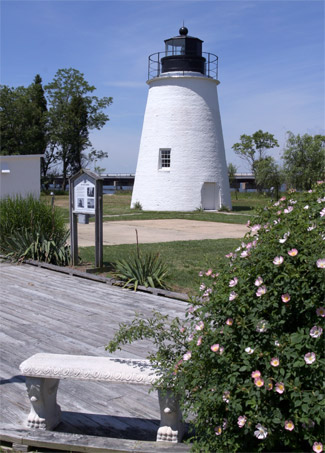
Located near the mouth of the Potomac, some 14 miles from where the
river meets the Chesapeake, Piney Point is among the oldest
lighthouses on the waterway, dating from 1836. For more than a
century (1836-1964) it served as a beacon of safety for mariners
seeking to navigate treacherous shoals. Only a few short decades
before its construction, however, in 1813-1814, ships of a very
different variety were patrolling the Potomac in close proximity to
the Point, as both American and British vessels made their way up
and down the river engaged in the deadly business of war.
Unfortunately, for the many farms and small towns that lined the
Potomac, the British invaders did not always remain aboard their
vessels. Communities on both the Maryland and the Virginia side of
the waterway, including many in St. Mary’s County, home to
Piney Point, suffered attack, experiencing incursions that would
devastate much of the region, causing significant loss of
population. Protection was left almost entirely in the hands of
local militia, as military leaders in nearby Washington, repeatedly
refused to send any additional troops as protection. One
particularly bad stretch occurred in the spring of 1813, when
British ships, under the command of John B. Warren, began
systematically raiding, pillaging and burning the countryside. This
included the take-over of a number of small islands near Piney
Point, including nearby St. George’s as well as occupation of
Point Lookout.
In July of 1813, an exciting chase, which might have been seen from
the Point, occurred up the Potomac. As described in the book,
Terror on the Chesapeake: The War of 1812 on the Bay, on July 14,
British cutters went in chase of the schooner Asp and the sloop
Scorpion, two vessels of the Potomac Flotilla. The ships had been
sent to reconnoiter the mouth of the river and ascertain the
enemy’s position. The Scorpion managed to escape, most likely
making its way with all haste past Piney Point. It went on to
become the flagship of the Chesapeake Flotilla under Commodore
Joshua Barney. The Asp, however, was engaged by the British and
suffered casualties, including her commander and ten other crew
members killed. The ship itself was destroyed. Following the
battle, the British continued up the River, eventually coming
within 40 miles of the capital, only to be turned back by the rocky
Kettle Bottom shoals. Similarly impressive (though frightening)
views would once again await residents of coastal St. Mary’s
County during the late summer of 1814, when enemy vessels made
their way up the Potomac, this time with Alexandria and Washington,
D.C. squarely in their sights.
As the British expanded their presence in St. Mary’s County
in 1813, through raids and the take-over of key coastal areas,
hundreds of African American men and women sought to escape slavery
and seek freedom through joining these forces. This caused panic
among white citizens, who feared that freed people would not only
aid the British, but also potentially return to the site of their
enslavement to seek vengeance. Though historians have found little
evidence of any revenge taken by African Americans, there is ample
material demonstrating the impact of their service. Serving as
guides and scouts as well as soldiers, they provided significant
aid and assistance to the British. Indeed, one of the primary
reasons that Commodore Barney set out to challenge the British so
quickly with not-yet-completed Chesapeake Flotilla in May 1814 was
to halt the military training of African American men on Tangier
Island (known as Fort Albion by the British).
Today, Piney Point Lighthouse Museum & Historic Park preserves
and interprets the story of the Lighthouse as well as a collection
of historic Chesapeake Bay workboats. During a visit, you can climb
the lighthouse and learn the story of how Washington dignitaries,
including several U.S. presidents, came to the site. A 6-acre park
surrounds the lighthouse and keepers quarters with a picnic area,
kayak launch, a boardwalk, pier and sandy beach. The museum also
includes artifacts from the WW II U-1105 Black Panther German
submarine, which lies just offshore in an area designated as the
state’s first Historic Shipwreck Dive Preserve. Grounds open
sunrise to sunset, 7 days a week. The Museum and Lighthouse Lens
Museum Store open April 3 – September, 10 a.m. – 5 p.m.
Open weekends only October – third weekend in December, Noon
– 4 p.m. Group and student tours are available.

Thanks to Terri & Billy for helping
with this hide and to the Maryland Geocaching Society for assisting
with this
project!