The Esterel range, is an old mountain (Hercynian type). It was
constitued during Permian Era (-290 million years).The"
Mont Vinaigre" is the highest peak (2015
ft).Before the formation of the Mediterranean sea, this
piece of land was a part of Africa. During
Tretiary Era, a part of Esterel was detached from the mainland.
Corsica was borne.
290
million years ago, here, the Earth's crust was deeply cracked.
Therefore, the lava spread all over this place and has created a
red crimson layer called red porphyry. Sometimes this red
porphyry was mixed with a blue one. Those
rocks have colored the Esterel landscape. After
this first volcanic activity, about 200 volcanoes have risen and
the "Bonnet du Capelan" was one of them. During 30 million years,
those volcanoes have belched basalt, sandstone and porphyry to
create volcanic domes. During the Secondary Era ( Mesozoïc; - 150
million years), the "Bonnet du Capelan" and the
others was eroded. The rain and the wind has exposed the volcanic
neck of the "Bonnet du Capelan".
This volcanic neck called also
volcanic plug was created when lava hardened within the vent when
"Bonnet du Capelan" was active. When forming, a
neck can cause an extreme build-up of pressure if volatile charged
magma is trapped beneath. Sometimes, it can lead to an explosive
eruption. Here, the neck was preserved and the erosion has removed
surrounding rocks while the erosion-resist neck remained providing
a distinctive landform called "Bonnet du Capelan".
This geographic feature helped the celts to buid, many years ago,
an oppidum above it.
Process of exhumation

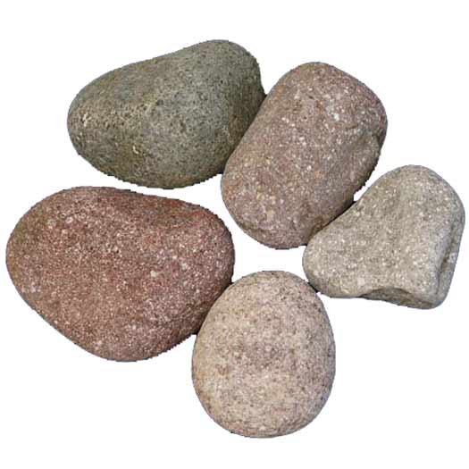
Blue and Red
Porphyry
Le massif de
l'Esterel date de l'Ere Primaire.C'est un massif
de type Hercynien.Le Mont Vinaigre est son point
culminant(614m). Ce morceau de terre était attaché
à l'Afrique avant la formation de la mer Méditerranée. Au Tertiaire
une partie se détache et forme la
Corse.
Il y a 290 millions d'années,
ici, l'écorce terrestre se fissure profondément et laisse remonter
à la surface une couche rouge pourpre: le porphyre rouge et une
autre moins abondante le porphyre bleu. Après cette phase de
volcanisme fissural, de vrais volcans vont s'édifier. A cette
période se forme le Bonnet du Capelan. On pense
qu'il existait près de 200 bouches volcaniques.Ces volcans étaient
de type explosif strombolien.L'activité volcanique durera près de
30 millions d'années .Il en résulte une forte émission de basalte,
de grès et de porphyre.Le Bonnet du Capelan va
subir à l'Ere Secondaire (Mésozoïque, -150 millions d'années) une
forte érosion.La pluie et le vent vont continuer leur action.Ils
vont alors éroder les bords du dôme volcanique et faire apparaître
un neck volcanique.
Ce neck représente la cheminée
du volcan formée de roches magmatiques pétrifiées.Le neck du
Bonnet du Capelan présente avec ses parois
abruptes un réel avantage pour les peuples celto-ligures qui vont
pouvoir y construire un oppidum.
You can log this Earthcache by
submitting:
- a picture showing you or your
GPS unit in front of the "Bonnet du Capelan"
and please answer the
following tasks/research questions
- What is the other name of the
red porphyry?
- What is the other name of the
blue porphyry? (a part of this name comes from this
Mountain)
- What is the height of the
"Bonnet du Capelan"?
Pour valider cette Cache de la
Terre:
- Merci d'envoyer une photo de
vous ou de votre GPS unit devant le "Bonnet du Capelan"
et aussi de répondre à
ces trois questions (pas sur le log mais par
courriel):
- Quel est l'autre nom du
porphyre rouge?
- Quel l'autre nom du porphyre
bleu?
- Quelle est l'altitude du
"Bonnet du Capelan"?