Hohe Klinge
Introduction - Einführung
 Mining has a long
tradition in Thuringia and is an important topic in the
development of the country. The Thuringian Forrest was of high
interrest for the mining industry, because a huge amount of
near-surface ore and mineral deposits could be digged easily
by open-cast mining. You can explore one of this deposits, the
"Hohe Klinge" deposit near Trusetal, by this multi-stage
EarthCache.
Mining has a long
tradition in Thuringia and is an important topic in the
development of the country. The Thuringian Forrest was of high
interrest for the mining industry, because a huge amount of
near-surface ore and mineral deposits could be digged easily
by open-cast mining. You can explore one of this deposits, the
"Hohe Klinge" deposit near Trusetal, by this multi-stage
EarthCache.
 Bergbau hat eine
lange Tradition in Thüringen und stellte einen wichtigen
Faktor für die Entwicklung des Landes dar. Der Thüringer Wald
war von großem Interesse für die Bergbauindustrie, da reiche
Erz- und Minerallagerstätten nahe der Oberfläche technisch
wenig aufwändig im Tagebau abgebaut werden konnten. Eine
dieser Lagerstätten, die "Hohe Klinge" bei Trusetal, wollen
wir dir in diesem EarthCache vorstellen.
Bergbau hat eine
lange Tradition in Thüringen und stellte einen wichtigen
Faktor für die Entwicklung des Landes dar. Der Thüringer Wald
war von großem Interesse für die Bergbauindustrie, da reiche
Erz- und Minerallagerstätten nahe der Oberfläche technisch
wenig aufwändig im Tagebau abgebaut werden konnten. Eine
dieser Lagerstätten, die "Hohe Klinge" bei Trusetal, wollen
wir dir in diesem EarthCache vorstellen.
Geology - Geologie
The former opencast
pit and underground mine "Hohe Klinge" is located at the
southern boundary of the Thuringian Forest between the
villages Trusetal and Steinbach. It is a hydrothermal ore and
mineral deposit, mainly composed of brown haematite (FeOOH)
and baryte (heavy spar, BaSO4). Hydrothermal deposits are
generated while hot fluids (100-200° C) are circulating in a
depth of about 4 km along veins, cracks and fissures through
the host rocks and then cooling down and crystallizing. If
those cracks open and close periodically by tectonic forces,
elongated ore and mineral bodies are formed, like we can see
at the Hohe Klinge.
Der ehemalige Tage-
und Tiebbergbau "Hohe Klinge" liegt an der südlichen
Begrenzung des Thüringer Waldes, zwischen den Orten Trusetal
und Steinbach. Es handelt sich um eine hydrothermale
Lagerstätte, in der hauptsächlich Hämatit (FeOOH) und Baryth
(Schwerspat, BaSO4) kristallisierte. Hydrothermale
Lagerstätten entstehen, wenn heisse Fluide (100-200° C) in
einer Tiefe von etwa 4 km durch offene Brüche, Klüfte und
Spalten zirkulieren, auskühlen und schliesslich
kristallisieren. Wenn diese offenen Brüche sich, bedingt durch
tektonische Kräfte, im Laufe der Zeit mehrfach öffnen und
schliessen entstehen langgestreckte Erz- und
Minerallagerstätten wie die der Hohen Klinge.
 |
|
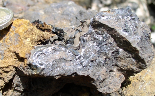
Brown haematite or Limonit: The
iron-bearing mineral is Goethit (FeOOH). Goethit occures as a
secondary mineral in the oxidized zone (iron hat) of veins
containing iron bearing minerals.
Hämatit oder Limonit: Das
eisentragende Mineral ist Goethit (FeOOH). Goethit tritt als
Sekundärmineral in der Oxidationszone von Klüften auf (Eiserner
Hut), die mit eisentragenden Mineralen verfüllt
sind. |
 |
|
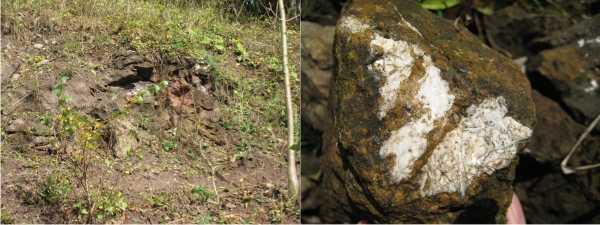
Baryte or heavy spar (BaSO4):
Baryte is the most common mineral of barium. It occures as a vain
filling and is often accompained by ores of lead, copper, zinc,
silver, iron and nickel. With it's high specific gravity of ~4.5,
it is mainly used as a drilling fluid, but for white colour pigment
as well as in X-ray technology.
Baryth oder Schwerspat
(BaSO4) ist das häufigste bariumtragende Mineral.
Es entsteht als Kluftfüllung und ist häufig in Assoziation von
Erzen zu finden wie Blei, Kupfer, Zink, Silber, Eisen oder Nickel.
Wegen seiner hohe spezifische Dichte von 4.5 wird es heute
hauptsächlich als Bohrspülung in Tiefbohrungen benutzt, früher aber
auch als weisses Pigment in Farben oder in der
Röntgen-Technologie. |
History - Geschichte
About 2000 years ago,
the Kelts started mining in the region of Trusetal. Officialy,
the upcoming mining settlement "Ottinrode" is documentary
since 1183, ore and mineral digging is documentary since 1563.
In the 18th century, mining is focused on baryte, in the
middle of the 20th century most mines where closed stepwise.
Mining was of extreme importance for the regional development.
Roads and settlements where built, fortified and secured
(fortress and castle Wallenburg, 1249). The ore was processed
and sold in the settlements, hammer mills, melting furnaces
and smithies developed.
Vermutlich schon vor
2000 Jahren begannen die Kelten in der Region um Trusetal,
Bergbau zu betreiben. Das aufblühende Bergbau-Dorf "Ottinrode"
wird 1183 erstmalig erwähnt, Erzbergbau ist offiziell seit
1563 verbrieft. Im 18. Jahrhundert konzentrierte sich der
Abbau auf Baryth, in der Mitte des 20. Jahrhunderts wurden die
meisten Bergbaue schrittweise geschlossen. Der Bergbau war von
entscheidender Bedeutung für die regionale Entwicklung:
Strassen und Dörfer wurden gebaut, befestigt und gesichert
(Festung und Burg Wallenburg, 1249). Das Erz wurde in den
Siedlungen verarbeitet, es entsatnden Hammermühlen,
Schmelzöfen und Schmieden.
Parking - Parkplatz
You can drive with
your car from Trusetal to direction Steinbach all the way up
following the sings "Hohe Klinge". A few parking places free
of charge are availibel at N50° 48.717 E10° 23.920.
Mit dem Auto aus
Trusetal Richtung Steinbach kommend den Schildern "Hohe
Klinge" folgen. Einige kostenfreie Parkplätze sind bei N50°
48.717 E10° 23.920 vorhanden.
Stage 1: Klinger Stollen Ost - N50°48.772
E10° 23.964
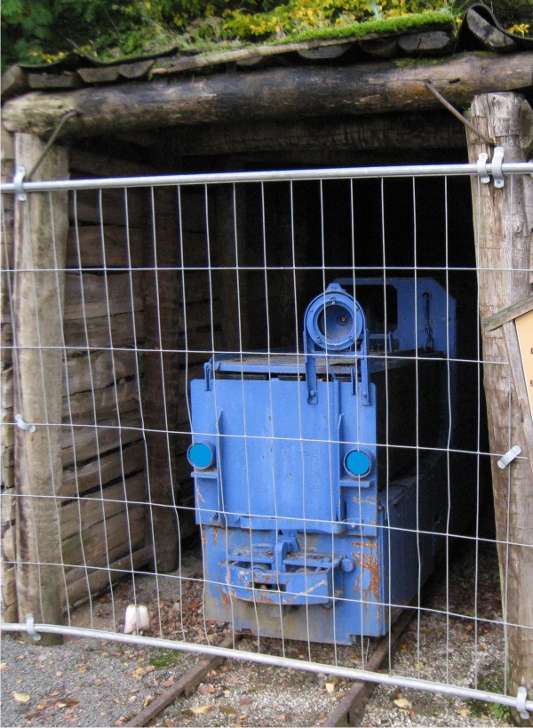
Here you can find the
mouth of the gallery "Klinger Stollen Ost". Starting from
1920, the iron ore was transported to Trusetal by a funicular.
Until 1951 only iron ore was digged, later Baryt as well. In
1969 the gallery was shut down and filled in 1975. The picture
below shows the rebuilt entrance to the former gallery and a
blue lorry, which was used for ore transportation inside the
gallery.
Question 1:
When was the gallery "Klinger Stollen Ost" established?
Hier befindet sich
der Stolleneingang des "Klinger Stollen Ost". Seit 1920 wurde
das Eisenerz aus diesem Stollen mit einer Seilbahn nach
Trusetal transportiert. Bis 1951 wurde ausschliesslich
Eisenerz gefördert, später auch Baryth. 1969 wurde der Stollen
stillgelegt und 1975 verfüllt. Das Bild unten zeigt den
nachgebauten Eingang zum ehemaligen Stollen mit einer blauen
Lore, die zum Materialtransport innerhalb des Stollens
diente.
Frage 1: Wann wurde der Klinger
Stollen Ost angelegt?
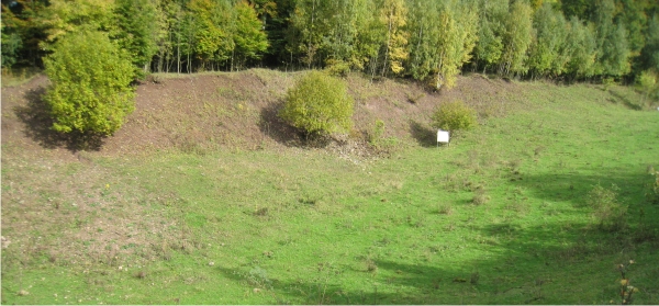
Stage 2: On top of Hohe Klinge (elev. 575
m) - N50° 48.999 E10° 23.662
The "Hohe Klinge" is
a traditional mining area. The NW-SE trending mineralized
ore-bearing dyke was easily accessible from the land surface.
That's one of the reasons, why our ancestors started mining in
this area allready about 2000 years ago. At the coordinates
given above, you will find a resting place with two
interesting information boards. Check out both and you will
get additional interresting information about mining,
landscape development and wildlife.
Question 2.1:
From when to when was the last period of open pit mining at the
Klinge dyke?
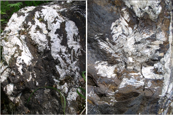
About 40 metres from here to the SE, there is a
remnant from the ore body. It gives a good insight to the internal
structure and composition of the ore deposit. Find your way either
along the small path through the bushes or by just go back the main
way and turn left. The outcrop is shaped like a cone with an hight
of about 6 metres and a diameter of about 8 metres. The outcrop is
declared as a natural monument, so you are not allowed to use your
hammer here (you will get the change to collect specimens at Stage
3). But if you look carefully at the outcrop, you can find veins an
cracks filled with the iron ore and baryte as well. The host rocks
and the whole outcrop is quite weathered, and debris from the
outcrop is located nearby.
Question 2.2: What is the main
colour of the host rocks and the weathered debris around the
cone-shaped outrop ?
A: greyish-bluish, B: yellowish, or C: reddish

Die Hohe Klinge ist
ein traditionelles Bergbaugebiet. Der NW-SE-verlaufende
Erzgang war von der Oberfläche aus leicht abzubauen. Dies mag
einer der Gründe sein, warum unsere Vorfahren hier schon vor
rund 2000 Jahren Bergbau betrieben. An den obigen Koordinaten
gibt es einen Rastplatz mit zwei interessanten
Informationstafeln. Schaue dir beide an und erfahre
zusätzliche Infromationen über den Bergbau, die
Landschaftsentwicklung und das Tierleben.
Frage 2.1: Von wann bis wann war
die letzte Periode des Tagebergbaus im Klinger Gangzug?
Etwa 40 m südöstlich von hier gibt es einen
kleinen Aufschluss aus Überresten des Ergkörpers. Er gibt
interessante Einblicke in die interen Struktur und Zusammensetzung
der Lagerstätte. Folge dem Pfad durch das kleine Wäldchen oder gehe
den Weg einige Meter zurück und dann nach links. Der Aufschluss ist
kegelförmig mit einer Höhe von etwa 6 m und einem Durchmesser von
etwa 8 m. Es ist ein geologisches Natrudenkmal und somit darf hier
nicht gehämmert werden (es gibt Stücke zum mitnehmen ab Stage 3).
Wenn man sich den Aufschluss sorgfältig ansieht kann man baryth-und
erzgefüllten Gänge und Klüfte erkennen. Das Wirtsgestein und der
ganze Aufschluss ist recht stark verwittert und die
Verwitterungsreste liegen am Fusse des Kegels.
Frage 2.2: Was ist die auffällige
Farbe des Wirtsgesteins sowie der Verwitterungsreste um den
Aufschluss herum?
A: gräulich-bläulich, B: gelblich oder C:
rötlich
Stage 3: Inside of the former Klinge dyke
- N50° 49.094 E10° 23.558
At this stage you are
standing directly in the former pit. An tablau gives
additional information about the mining. The U-shaped NW-SE
trending pit is clearly traceable for several hundreds of
metres downslope up to Steinbach. Near the information table,
there are several smaller outcrops of remnants of the iron ore
and baryte. You may use your hammer and look for nice pices
for your collection here.
Question 3 and
duty: In which year was undergroung mining suspended here?
Make a picture of you and/or your GPSr in front of the outcrop near
the information table!
An diesem Punkt steht
du genau in der Grube des ehemaligen Tagebaus! Ein
Hinweisschild gibt weiter Informationen zum Bergbau. Das
U-förmige, nordwet-südost verlaufende Tal der ehemaligen Grube
lässt sich leicht mehrere hundert Meter hangabwärts bis nach
Steinbach verfolgen. In der Nähe der Informationstafel gibt es
mehrere kleine Aufschlüsse, in denen man Baryth und Eisenerz
finden kann. Hier darf man auch hämmern und sich schöne Stücke
für die Sammlung mitnehmen.
Frage 3 und Aufgabe: In welchem
Jahr wurde hier der unertägige Abbau eingestellt? Mache ein Foto
von dir und/oder deinem GPSr mit dem Aufschluss nahe des Schildes
im Hintergrund.
Requirements for logging this
EarthCache
Send us an e-mail with the answers to the logging
questions above. If the answers are correct, we will send you the
permission to log this EarthCache. In your log you must attach a
picture of you and/or your GPSr in front of the outcrop at Stage 3.
Do not post answers in your log or attach pictures showing any of
the information tables. Logs without permission or without picture
will be deleted.
Logbedingungen für diesen
EarthCache
Schickt uns eine e-mail mit den Antworten auf die
Fragen. Wenn die Antworten richtig sind, erhaltet ihr von uns die
Logfreigabe für diesen EarthCache. Deinem Log muss ein Foto von dir
und/oder deinem GPSr vor dem Aufschluss bei Stage 3 angehängt sein.
Poste keine Antworten in deinem Log und zeige keine Fotos, auf
denen die Informationstafeln zu sehen sind. Logs ohne Logerlaubnis
oder ohne Fotos werden gelöscht.