|
 Laacher See: Schlackenkegel Laacher See: Schlackenkegel
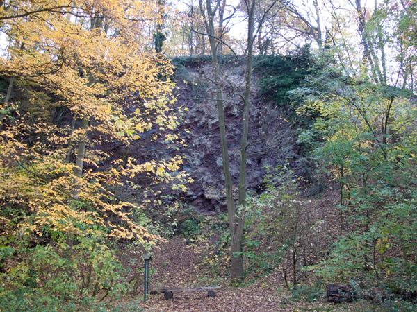
Die als "Jägerspitze" bezeichnete kleine Halbinsel ist der östlichste Teil eines Basaltschlackenkegels. Hier stand einst die Burg des Pfalzgrafen Heinrich II. bei Rhein, des Stifters der Abtei Maria Laach, deshalb nennt man diesen Bergvorsprung auch "Alte Burg". Der seewärts gelegene Teil des Vulkans ist entweder beim Einbruch der Caldera abgesunken oder durch die Bims-Eruption weggesprengt worden.
Der Steinbruch zeigt sehr deutlich den Aufbau eines Schichtvulkans: in die roten Basaltschlacken sind kleine graue Lavabänke eingeschaltet, die aus größeren ausgeworfenen Lavatropfen entstanden. Rechts oben werden die Schlacke von Löß überlagert, auf ihm liegt noch ein anderes Material. Der Alte-Berg-Vulkan ist also älter als die Laacher Bimseruptionen.
Schlacken- und Aschenkegel sind eine Art von Vulkanen. Sie erreichen meistens nur eine Höhe von zehn bis wenige hundert Meter bei einem Durchmesser von höchstens einigen hundert Metern und sind damit wesentlich kleiner als die bekannteren Formen Schichtvulkan und Schildvulkan. Schlackenkegel setzen sich aus größeren Lapilli, vulkanischen Bomben und Bimssteinbrocken zusammen. Diese Bestandteile sind groß genug, um nach dem Ausstoß noch nahe an der Schmelztemperatur zu landen und so den Kegel zu verbacken. (Quelle: Wikipedia)
Die Fragen
Bitte begebt euch an die oben genannte Koordinate. In der Nähe befindet sich eine Informationstafel. Lest euch die Tafel bitte sorgfältig durch und beantwortet folgende Fragen:
- Rechts oben im Steinbruch wird der Löß von welchem vulkansichen Gestein überlagert?
- Wie hoch ist der Steinbruch (geschätzt)?
Achtung! Es werden genau die Angaben gesucht, die auf der Tafel gemacht werden! Internet Lösungen können leider nicht akzeptiert werden.
Die Log-Bedingungen
- Bitte schickt uns eine Email mit den Antworten für die Fragen.
Sehr Wichtig! Bitte gebt im Betreff den EarthCache Namen und euren GC Namen mit an!
- Zeichne eine handgemalte Skizze des Steinbruchs. Füge das Bild deinem Log-Eintrag hinzu. Logs ohne Skizze werden kommentarlos gelöscht!
- Bitte macht freiwillig ein Bild von euch oder eurem GPS vor dem Steinbruch und fügt es eurem Log-Eintrag hinzu.
Ihr könnt dann sofort loggen.
Falls etwas nicht richtig ist, werden wir uns bei euch melden!
Wir hoffen euch macht dieser EarthCache genau so viel Spaß wie uns! Wir danken euch für euren Besuch und freuen uns auf eure E-Mails!
Liebe Grüße Kate!
Waymarking
In Kombination mit dem Cache kann auch der Waymark WM7PJJ gelogged werden.
 Laacher Lake: Cinder Cone Laacher Lake: Cinder Cone
This EarthCache leads you to the small peninsula "Jägerspitze" the most eastern part of a Basalt cinder cone. The quarry shows beautifully the structure of a stratovolcano. Between the red basalt cinder layers you can see grey solidified lava layers originated from ejected lava drops. On the top right the cinder is overlaid from loess and another material of volcanic rock. So the "Alte-Burg-Vulkan" (Old-Castle-Vulcano) is older than the Laacher pumice stone eruption.
Cinder cones are the simplest type of volcano. They are built from particles and blobs of congealed lava ejected from a single vent. As the gas-charged lava is blown violently into the air, it breaks into small fragments that solidify and fall as cinders around the vent to form a circular or oval cone. Most cinder cones have a bowl-shaped crater at the summit and rarely rise more than a thousand feet or so above their surroundings.
Questions
Please, head for coordinate mentioned above. Thereabouts is an information board. Read the board carefully by and answers the following questions:
- On the top right the loess is overlaid from what kind of volcanic rocks?
- Which hight has the quarry (estimated)?
Attention! The precise details are required, provided on the board! Unfortunately, solutions found in the internet cannot be accepted.
Log terms
- Please send us an Email with the answers to the questions above. Please wait for approval Email before you make your log. Important! Please add your GC Name to Email Subject!
- Draw a selfmade picture of the quarry. Please add it to your log.
- Please take a optional picture of you or your GPS in front of the quarry and add it to your log.
Logs without approval Email and painting will be deleted without comment.
We hope you will enjoy this EarthCache as much as we do. We thank you for your visit and are looking forward to your e-mails!
Kind regards, Kate!
Waymarking
In combination with this cache you can log Waymark WM7PJJ.
Statistik / Statistics
Historie / History
- 17.11.2009 Listing erstellt. / Listing created.
- 18.11.2009 Deutsche Beschreibung. Waymarking/Openaching hinzugefügt. / German description. Waymarking/ Openaching added.
- 19.11.2009 Coin Hinweis hinzugefügt. Coin Hint added.
- 08.12.2010 Coin Hinweis entfernt. Coin Hint removed.
- 23.01.2011 Bild optional. / Picture optional.
- 17.07.2011 Log Bedingungen vereinfacht. / Log terms simplified.
- 13.05.2012 Opencaching entfernt. / Opencaching removed.
|