GAWIE SE WATER AND OTHER STORIES
Approximately 3.5km one-way along a fairly level jeep
track, but allow time to savour the surroundings.
Note that you are supposed to have a permit to walk in
this area. Permits for this area (it's called Limietberg,
Capedoc) can be obtained (wildcards work, I think) at Bainskloof
Corner Lodge (021-864 1159 coords approx S33 36.969 E19
06.045, not sure about open times but probably quite flexible)
Wellington Tourism (021 873 4604 S33 38.483 E19 00.227, Mon-Fri
08h00-17h00 Sat-Sun 10h00-13h00) , Capenature in Paarl (021 871
1536 - don’t ask me why Paarl tourism does not issue permits) or
contact CapeNature Call Centre 021 659 3500). Tourism offices are
probably not open when you want to go caching so a little planning
is required.
Allow me to take you on a journey into some fascinating
history in the Bainskloof Mountains. Park at S33 37.426 E19 05.845
(PK) and pass underneath the cable gate to follow the jeep track.
Ever wonder where this track goes? Well you are about to find
out!
Your first stop is at S33 38.279 E19 06.428 (P1). Here is
a memorial in recognition of the Witterivier tragedy of 1895. A
group of students from Wellington went hiking up the mountains and
the weather turned
foul. The party split
into two, with the stronger party going back to the village for
help and the slower party were forced to
stay overnight on the
other side of the river. It rained all night and the river turned
into a raging torrent. It was so cold there were reports of snow on
Table Mountain. The next day the rescue party managed to secure a
rope across the river.
The first to attempt the crossing was a girl by the name of Lettie
de Jager. She got as far as the middle of the river, where she
managed to cling on to an outstanding rock, but she could progress
no further. Three young men tried to help but also only got as far
as the rock where they all succumbed to the cold after about 2
hours. Later that day the remaining survivors where winched across
at a safer
spot. Mr Hugo of
the next story erected the memorial. A sad reminder that beauty and
danger can be close companions.
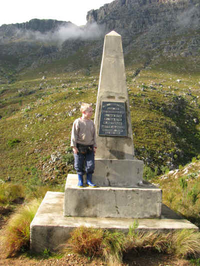
Markus
from tom&sons at the memorial in June
2008
Next go to S33 38.611 E19 06.470 (P2). Here you will see
what remains of Mr Hugo’s house. Mr Hugo was the prosperous owner
of Hugo’s jam factory.
You can still see the remains of his factory today in Bain Street
down in Wellington (S33 38.461 E19 00.608 - go and have a look).
The factory was subsequently the site of the Dietman piano factory
and now it is an upmarket residential development called “The Piano
Factory”. There was quite a debate whether the development should
be called “The Jam Factory” or “The Piano Factory”, but evidently
the latter fell more poetically on the well-heeled ears of the
inhabitants.
Jam was big business in those days: There was Hugo’s in
Wellington, Langeberg and Jones in Paarl, Rhodes Fruit farms (RFF)
in Simondium and Gants in Somerset West, to name but a
few. Of those
Langeberg and Jones ended up as part of Tiger Brands and RFF still
do a bit on the side. The name Hugo is still used as one of Tiger
Brand’s names for premium quality jams. Jam and canning is a
fraction of the industry it used to be before the widespread use of
cooling facilities and also due to the apparent increase health
awareness of the world – people prefer fresh fruit and such healthy
foods such as take-aways and fast foods…
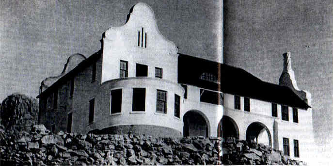
Wolkerus or "Clouds Rest" after completion in
1941
Anyway, Mr Hugo developed this notion to build a house in
the mountains of Bainskloof. He had this road built that you are
walking on and built the house in the 1940’s, complete with
swimming pool. Unsurprisingly his wife refused to go and live
there. Mr Hugo died before he could move into his house and so the
house stood empty for 8 years until it burnt down in a veld fire in
1949. Mr Hugo must have died a sad
man. I can clearly
remember as a child the “spookhuis” (Ghost house) standing there
hauntingly high up in the mountains. Only some walls and the gable
ends were still standing at the time. You can imagine what spooky
images were conjured up in a child’s mind. Sadly an escaped convict
murdered two hikers there in 1978 and the ruins were demolished to
the foundations, so all that is left is what you see
today.
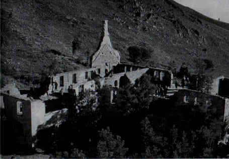
After the
fire, February 1949

An artist's
(my sister's) impression of the spookhuis as I imagined
it.
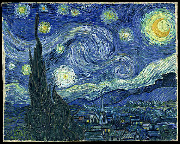
This painting
catches the spooky atmosphere quite well (A Starry Night by Van
Gogh)
I had a huge workout today (31 October 2009) clearing
blackwattle around the watercourse running down next to the
spookhuis, and so an opportunity presented itself to place this
cache, which I have wanted to do for a long time. We rode all the
way there in a rather low clearance 2x4 bakkie – quite
exciting.
Now go to the cache at S33 38.729 E19 06.532 (listed
coordinates). Nearby there is a small bridge over a deep cutting in
the rock that we call “Gawie se water”. This cutting diverts water
from the Witterivier down to the farms of the Bovlei in Wellington.
Interestingly here water is diverted from the Witterivier, which
flows to the Breede river that enters the Indian Ocean at Cape
Infanta near Swellendam to the Berg River which enter the Atlantic
ocean at Velddrif.
Thomas Bain who built the pass in the 1850’s offered to
make this cutting for £600, but the local farmers thought that was
too much money. Gawie Retief of the farm Kanetfontein (a cousin of
the voortrekker Piet
Retief) took it upon himself to excavate the cutting, which was
completed by 1860 at three times the price!
I had ideas to place the cache at the bottom of the
cutting, so that you have to take off your shoes and walk in the
water, but I am feeling kind and generous. When I placed the cache
I peered below the bridge deck and had a Discombob moment, tempted
to place the container perched on a ledge below the deck. Instead,
as this is an educational expedition, I have placed the container
at a very easily accessible spot. I invite you to have a look and
comment if there are any better spots to place the
cache.
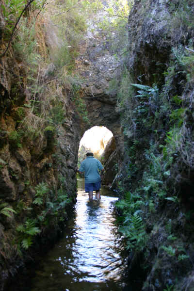
My brother Nicky walking in the
trench below the bridge in January 2005. My but the time
flies!
I strongly recommend you walk further along the jeep
track, or in the trench to find out where the water is diverted
from the river itself. There are lovely places for a picnic and a
swim. Enjoy.
Near the weir
where the water is diverted from the Witte rivier (January
2005)
Acknowledgements: I wrote most of these stories from
memory, but naturally I must have got them into my memory from
somewhere. Thanks to research by Mrs Pooks and the booklet
"Bainskloof and other tales" by Winnie Rust for some pictures and
correction of details.