What is groundwater?
Everywhere in the soil there is water. Sometimes you have to dig deep to find it and sometimes it is so high that you get wet feet. The state of groundwater is not always same. In summer, groundwater is lower than in the winter. That's because in summer the plants grow and suck up groundwater and evaporate. The waterdepth varies from season, but may also change through watermanagement. Falling and rising underground The level of groundwater has fallen considerably in recent decades. There are deep ditches dug and streams corrected to effectuate rapid discharging to rivers. This is often beneficial for agriculture and for housing and roads. In nature the lower waterdepths are not favorable, nature is thirsty. The groundwater is now in many natural areas in Noord-Brabant too low. They suffer from desiccation. Desiccation is changing the living conditions for plants and animals, and the types who really love wet feet disappear.
Geology
The Netherlands are created by water. In fact, our country is mainly a so-called delta.The great rivers, wich have their origin in the higher parts of Europe, bring materials wich are depostied here as sediment.This is called a fluvial proces. Sediment is transported based on the strength of the flow that carries it and its own size, volume, density, and shape. Stronger flows will increase the lift and drag on the particle, causing it to rise, while larger or denser particles will be more likely to fall through the flow. Over long periods of time, this deposition builds the characteristic geographic pattern of a river delta. At this place you can see how close or how far the water is under your feet. Groundwater Use Groundwater is used for drinking water, to make agricultural land and watering in the industry, for example, the soft drinks industry. Also these extractions lower the groundwaterlevel. Most of the drinking water is used for showering, washing and flushing the toilet. Through conscious and economical use of water, everyone can contribute to the prevention of desiccation of nature.
Is groundwater important to this district?
In our towns and villages rainwater usually disappears directly into the sewer. Heavy rainfall often leads to high water levels in our rivers and overflowing of the sewer. This is because the high peaks in the sewage flow of rainwater to process. As rainwater flows into the sewer system directly, also our gardens get too dry. Besides an ordinary sewer system is in this district also a separate rainwaterdrain constructed. This is called an infiltrationsewage from which rainwater is absorbed slowly into the soil. The rain water remains in the area where it falls down and makes the soil less drying. It will also prevent that during heavy rain the sewer becomes overloaded and the problem of high water reduced. The groundwater in the residential area has little effect on the natural areas outside the city, so this water meter gives the required level for residential groundwater again. This is up to standard. In many places in the Netherlands underground plastic pipes installed to measure groundwater levels, but these are (almost) not visible. At this site is a surface water meter fitted. A stainless steel tube with a viewing window in which to read how deep the water is under your feet. A "special place" with a clear geohydrological link, so a nice place for a earthcache.
LOGGING REQUIREMENT:
Fill in this Google Form (use a negative number, use no spaces): https://docs.google.com/forms/d/e/1FAIpQLSdIf yoy do not look pretty m8A4Cr-oy4u9f-ysOEAwYbx-2RhLSeM_v_Lr9ihBhv5sKrw/viewform?usp=sf_link
I would really like a picture of you with the watermeter in your log.
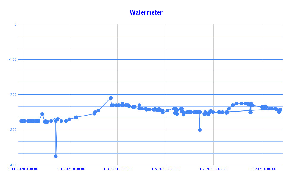
In the picture below you can see the result of the geocaching-measurements. Or visit this link for real-time: https://docs.google.com/spreadsheets/d/e/2PACX-1vQv2UFsG4pQ1gsthS3Hc8oFnVeDOcdtcuLVmWUnAFDn0MMuiBPR-IPnmMinxmmJ_f5eMBNu0W71mQt7/pubchart?oid=1929444333&format=interactive