Raderacher Drumlinfeld 🌍 EarthCache
-
Difficulty:
-

-
Terrain:
-
Size:  (other)
Please note Use of geocaching.com services is subject to the terms and conditions
in our disclaimer.
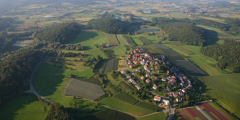
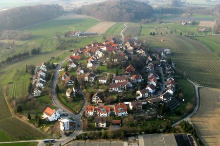
 Raderach ist in unserer Gegend dafür bekannt, daß es auf einem Drumlin erbaut ist. Aber was sind Drumlins ?
Raderach is well known in our region because it’s built on a drumlin. But what are drumlins ?
Raderacher Drumlinfeld
English version below.
Der Begriff Drumlin kommt vom irischen Wort "druim" und bedeutet übersetzt Erdhügel oder Höhenrücken.
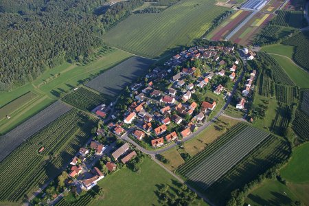 Drumlins sind längliche, walförmige (stromlinienförmige) Hügel, die durch Gletscherbewegungen während der letzten Eiszeit geformt wurden; ihre Längsachse verläuft parallel zur Fließrichtung des Gletschereises.
Die steilere Seite des Drumlins zeigt immer in die Richtung, aus der der Gletscher kam; die andere (sanft abfallende) Seite zeigt in Richtung der Eisbewegung.
Meistens bilden mehrere ein sogenanntes Drumlinfeld.
Wissenschaftler sind sich bislang nicht sicher, auf welche Art und Weise Drumlins genau entstehen. Da es hierzu mehrere Theorien und Hypothesen gibt, werde ich nicht näher darauf eingehen.
Drumlins bestehen gewöhnlich aus Moränenmaterial (Geschiebemergel) und werden einige zehn Meter hoch und bis zu 1.000 Meter lang.
Aufgaben:
- Frage 1: Ermittelt die Höhe des Drumlins Raderach gegenüber seiner Umgebung.
- Frage 2: Wie heißt die letzte Eiszeit (es ist nicht die Weichsel-Eiszeit) ?
- Frage 3: Wann begann und wann endete diese letzte Eiszeit ?
- Frage 4: Erklärt den Begriff "Moräne".
- Foto 1: Macht ein Foto von Euch, dem GPS und dem möglichst kompletten Raderacher Drumlin im Hintergrund.
oder
- Foto 2: Macht ein Foto von Euch, dem GPS und der Hintergrundlandschaft von der Anhöhe des Raderacher Drumlins.
oder
- Foto 3: Bei Dunkelheit: macht ein Foto von Euch, dem GPS und der Infotafel "Geheimnisvolles über die Fichtenburg" im Bereich der oben angegebenen Koordinaten.
Sendet die Antworten mit "send message" an mich und Ihr könnt sofort mit Eurem Foto loggen ( das Gesicht muß erkennbar sein ).
Es ist nicht notwendig, auf eine Logerlaubnis zu warten !
Drumlinfield at Raderach
The word drumlin comes from the Gaelic word "druim" meaning a little rounded hill or mound.
 Drumlins are elongated whale-shaped (streamlined) hills formed by glacial action during the last ice-age; the long axis is parallel with the movement of the ice.
The end with the steeper slope always faces the direction from which the glacier came; the other end (more gently sloping) shows the direction in which the glacier was moving.
They are often grouped together in drumlin fields (although called drumlin swarms).
Scientists are still not certain how drumlins originated. Because there are several theories and hypotheses, I will not come closer on it.
Drumlins usually consist of moraine (glacial till). They become several ten meters high and up to 1000 meters long.
ToDo:
- Question 1: Ascertain the height of the drumlin Raderach in meters.
- Question 2: What is the name of the last ice-age ?
- Question 3: When was the last ice-age (beginning and end) ?
- Question 4: Explain the word "moraine" ?
- Photo 1: Take a picture of you, the GPS and the Drumlin Raderach in the background.
or
- Photo 2: Take a picture of you, the GPS and the landscape from the top of the drumlin Raderach.
Send the answers to the owner via 'send message' and you can log immediately with your photo ( the face must be visible ).
It's not necessary to wait for an answer or for permission to log !
Additional Hints
(No hints available.)