|
The modern landscape of Taranaki is dominated by the volcanic peak known as Mt Taranaki, or Mt Egmont, but this is just the youngest in a line of volcanoes that have shaped the region over the past 2 million years. All four cones would probably have reached the height of the present mountain.
The youngest of the four Taranaki volcanoes is Mt Taranaki, active as recently as 250 years ago. At around 120,000 years old, Mt Taranaki is just a youngster compared to the older volcanoes in the series. It is considered dormant, but not yet extinct, and still has the potential for eruption on a large scale.
The next youngest volcano, effectively Mt Taranaki's father, is marked by the Pouakai ranges, which form the stumps of the volcano. The Pouakai volcano was active around 250,000 years ago. After numerous eruptions and dramatic cone collapses, a cone similar to Mt Taranaki was formed.
On at least five occasions, this cone too collapsed sending huge masses of material rushing to the west, beyond the present shoreline and covering the land between Okato and Hawera. These cone collapses are largely responsible for the curving Taranaki coastline seen today.
The Kaitake ranges are the remnants of the second oldest of the Taranaki volcanoes. The Kaitake volcano was formed by activity around 500,000 years ago.
All that remains of the great grandfather of them all, the oldest volcano, are the Sugar Loaf Islands/Ngaa Motu and Paritutu Rock near the port of New Plymouth, although unlike the others, they are probably not located at the centre of where the old volcano was. Along with the Kaitaki and Pouakai Ranges they complete a curved path of volcanic activity ending with Mt Taranaki's current peak and crater.

This earthcache will take you to the two extremes of this lineage of volcanic activity and you can visit them in whichever order you choose. The tasks you need to complete and questions you need to answer are outlined below:
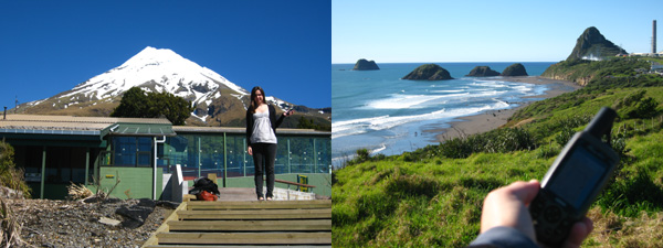
1. Visit the published coordinates and take a photo showing yourself, your GPS and the remnants of the oldest volcano. An example photo is shown below.
2. Visit the listed waypoint 1 (S 39 16.212 E 174 05.753). Here, between 8am and 4:30pm, you will find the answers to the following (you must email these answers to the cache owner):
- a. How many millions of years ago did the oldest volcano form?
- b. "Their eroded remains still host" what?
- c. The Kaitake Ranges, the base of the second volcano, have eroded to what fraction of its original height?
- d. When the third volcano, now the Pouakai Ranges, was active, what "was still on the planet then"?
3. Visit the nearby waypoint 2 (S 39 16.204 E 174 05.765) and while standing at the top of the wooden steps, take a photo showing yourself, your GPS, the visitor's centre and the mountain behind. An example of this photo is also shown below.
Please ensure that you email the answers to the questions above to the cache owner and post both of the required photos with your online log. Ensure that your GPS is visible in both photos for your log to be valid.
You can log this cache straight away after you have emailed your answers to the cache owner, no need to wait for confirmation. Please include the name of this earthcache in the email - you'd be surprised how many people forget. Also, when contacting us with answers, if you want a reply, please include your email address. Any problems with your answers we'll be in touch.
 |