The Aare Gorge | Aareschlucht | Gorges de l'Aar EarthCache
The Aare Gorge | Aareschlucht | Gorges de l'Aar
-
Difficulty:
-

-
Terrain:
-
Size:  (other)
Related Web Page
Please note Use of geocaching.com services is subject to the terms and conditions
in our disclaimer.
It seems someone recently put a cache box (still unpublished) in the Aare Gorge. That is NOT this cache here! Logs without submitted answers will be deleted after a while.
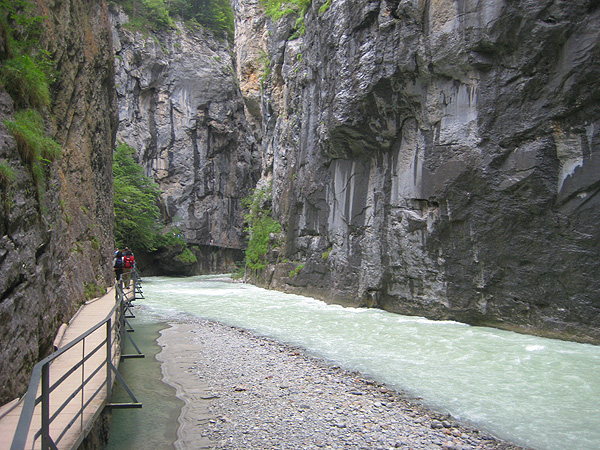
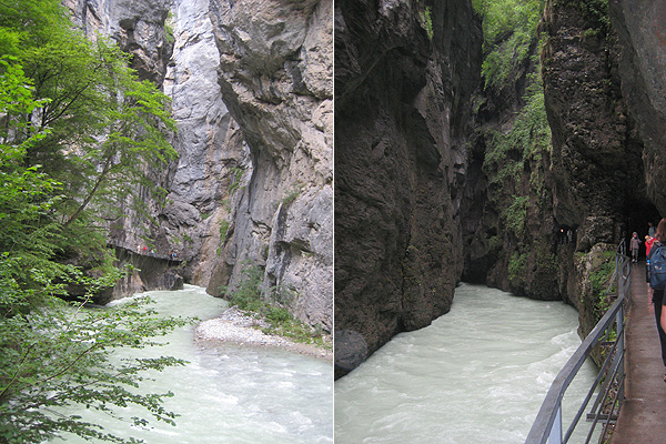
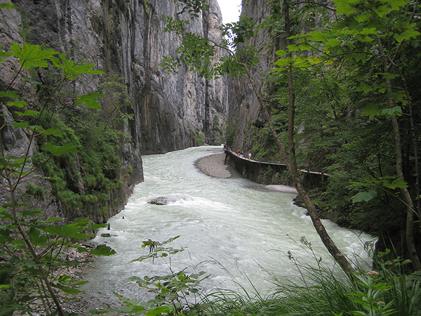
Over thousands of years, the Aare River eroded a path through this rock formation resulting in a gorge which is 1,400 meters long and up to 180 meters deep.
EN
The Haslital, one of the large valleys in the central alps, stretches from the Grimsel Pass to the Lake of Brienz. The flat valley floor of the lower Haslital is separated from the upper valley by a transverse rock formation. This rock formation called the "Kirchet" lies between Meiringen and Innertkirchen. Over thousands of years, the Aare River eroded a path through this rock formation. Length: 1,400 meters. Max. highth: 180 meters. Narrowest site: 1m large. Speed of water: 4 to 13km/h.
This gorge has been accessible for over 100 years by a system of safe paths and tunnels. The walk through the gorge is a very special way to experience nature. One can reach the west entrance of the gorge (N 46 43.200 E 8 12.280) just outside the village of Meiringen. The east entrance (N 46 42.730 E 8 12.980) is on the road from the Grimsel and Susten passes, 1km west of Innertkirchen. Free parking at both entrances. From Meiringen, you may also take the MIB railway that brings you to both of the entrances. You can hop off on either the east of west entrance.
Admission fees: Adult CHF 12.00, child 6-15 years CHF 7.50
See above web link for more information like opening times etc.
History
Until the Aare gorge was opened for tourists, only two side gorges were passable, by which one could reach the Aare River at approximately the middle of the gorge as it stands today. Otherwise, the gorge was only able to be reached by the dangerous option of the river, which was only very seldomly used. It was no wonder that fables began about this unknown gorge and its inhabitants. Once it was reported: "People believe that a type of snake with an almost round head and short feet can be seen at present." Many tales tell that this snake, known as a "Tatzelwurm", lives in the Aare Gorge.
The famous writer Johann Wolfgang von Goethe visited the Aare gorge in autumn 1779 during his travels in the Bernese Oberland. He climbed down through the “Finsteren Schlüüchen” at Lammi to the Aare river. His impressions of this journey are vividly described in the story “Indescribable Days”.
In 1887 the county of Bern gave permission to build a path through the "Aarlamm" from Sandey to the Finsteren Schlauche and up to the Hof-Meiringen road at Lammi. A handful of local citizens founded and financed a company which immediately began construction of the path. Within one year, the dangerous job was completed between both "Engen" and 12,000 people visited the gorge in that summer alone. In the following year, further galleries and pathes were completed. Ten years later, the wooden gallery path to the east entrance was built.
Geology
The rock formation between Meiringen and Innertkirchet is called the "Kirchet" and consists mainly of very hard limestone. This formation was created in the Cretaceous Period approx. 130 to 160 million years ago as ocean sediment which hardened to limestone over the years (sediment in the Thetis, the Geosynklinal ocean of the alps).
When the Alps were formed approx. 15 million years ago, these sediment deposits were vaulted into the sediment casing of the crystalline mountains, but the rock in the area of the Kirchet is autochthon, which means that it was barely moved.
As a result, the limestone here is very solid and resistant to water and ice. The glaciers of the ice age, which began about 1 to 2 million years ago, were able to erode the cliffs of the Kirchet, but not to carry them away.
In the first warm periods, as the glaciers receded, the water eroded a gorge through the cliffs. In the cold period which followed, the glacier once again covered the Kirchet which filled the gorge with moraine. During the next warm period, the melting water did not wash out the moraine, but instead cut out a new gorge between the cliffs and many new Aare Gorges were created during the ice ages.
A flyer about the most important spots is available in German, English, French, Italian, Dutch, and Japanese.
Your task
Take pictures in the gorge and upload one or more of them (as per January 2011, this task is optional):
– e.g. with yourself (your team) or your GPSR
– and/or that shows your favourite spot in the gorge
– and another one of your choice.
Preferrable write decent captions to all of them.
Do NOT send me the pictures! Upload them with your log, please.
Answer these three questions and send the answer to the owner (check the box “send along your e-mail address”, unless you use the message center):
What happenes at Schräybach (near stop #6):
Water contains (a) which erode the (b).
c) What is this process called? (Note: there is a new sign which gives the wrong answer in English! “mechanical” is wrong!)
Last task: At the west end of the gorge (approx. N 46° 43.241 E 008° 12.380) there is a board where you can learn something about erosion (only in German and English): compare the different types of water and find out if you are right.
You may log right after sending in your answers. You don’t need to wait for the owner’s confirmation. He will get back to you in case you answer is wrong or not complete. (Logs without message with solutions will be deleted.)
Note: These requirement are easy enough to comply with, so don't act minimalistic! The owner of this cache can delete (without prior notice) any logs which do not appear appropriate or with wrong/insufficient pictures or logs without acompanying mail with the correct answers.
Enjoy the gorge! It is worth your visit.
DE
Deine/euere Aufgabe
Mache Bilder und lade eines oder mehr hoch (gemäß Richtlinien vom Januar 2011 ist diese Aufgabe optional):
– z.B. mit dir/euch oder mindestens dem GPS-Gerät
– und/oder eines mit euerem Lieblingsplatz in der Schlucht
– und/oder ein weiteres gutes Bild.
Am liebsten mit einer Legende zum Bild.
Bitte Bilder NICHT mir schicken, sondern mit dem Log hochladen.
Beantworte folgende Fragen und schick sie dem Owner – bitte Mailadresse mitsenden (ankreuzen), außer bei Nachrichten über das Nachrichtencenter. Bis zur Antwort kann es ein paar Stunden bis max. drei Tage dauern.
Was passiert bei Schräybach (Station 6):
Wasser enthält (a), welche (b) zerfressen.
c) Wie nennt sich dieser Prozess?
Letzte Aufgabe: Beim Westende (etwa N 46° 43.241 E 008° 12.380) gibts eine Tafel, wo du etwas über Erosion lernen kannst: Vergleiche die verschiedenen Wassertypen und kontrolliere, ob deine Antworten stimmen.
Du darfst hier gleich nach dem Einsenden der Lösungen loggen und deine Bilder raufladen. Der Owner wird sich bei dir melden, wenn etwas nicht stimmen sollte. (Logs ohne Lösungsmail werden gelöscht.)
Achtung: Die Anforderungen sind nicht zu schwierig, also bitte nicht den Minimalismus raushängen! Der Owner behält sich vor, unzutreffende, unvollständige Logs jederzeit ohne Rücksprache zu löschen, dasselbe gilt für Einträge, die ohne E-Mail mit den korrekten Antworten gemacht wurden oder die sonstwie nicht den hier publizierten Bedingungen entsprechen.
Viel Spaß in der Schlucht! Der Besuch lohnt sich.
Eintrittspreise: Erwachsene CHF 12.00, Kinder 6-15 Jahre CHF 7.50
See above web link for more information like opening times etc.
Additional Hints
(Decrypt)
RA: Jurrypunve naq fgebyyre npprffvoyr bayl sebz gur jrfg ragenapr, v.r. lbh ragre naq yrnir guebhtu gur jrfg ragenapr. Rnfg raq vf abg greenva 1.
QR: Ahe ebyyfghuy- haq xvaqrejntratäatvt ibz Jrfgrvatnat ure, q.u. qh xbzzfg haq trufg qhepu qra Jrfgrvatnat. Qre öfgyvpur Grvy vfg avpug Tryäaqr 1.