Reich der Wasserzwerge
Das Wasser der Leutascher Ache hat sich im Laufe von 15.000 Jahren tief in den Wettersteinkalk eingegraben. Die Ursache dafür sind aber die Eiszeitgletscher. Dass sich die Ache in erdgeschichtlich kurzer Zeit sehr tief ins Gestein eingefressen hat, beweisen die sehr schroffen, teils überhängenden Felswände. Denn die Erosion hatte noch zu wenig Möglichkeiten, die scharfen Formen abzuschwächen.
Tief unten in der Alten Klamm befindet sich der Mittenwalder Wasserfallsteig. Bitte wirf in diesem Abschnitt der Klamm daher auf keinen Fall Steine oder andere Gegenstände hinunter! Du gefährdest sonst die Wanderer oder die Wasserzwerge!
Geisterbuckel
Bei den Header-Koordinaten angekommen, stehst du am Steilabbruch zur Geisterklamm an einer Stelle, die noch vor 10.000 Jahren von Eiszeitgletschern bedeckt war. Über diese Geländekante flossen sie ins Mittenwalder Becken hinab, um sich danach ihren Weg ins Alpenvorland zu bahnen. Hinter dir erheben sich die gerundeten Kuppen des Burgberges, die vom Gletscher ebenfalls überflossen und zu "Geisterbuckeln" abgeschliffen wurden. Die Klamm selbst hat sich erst während des Abschmelzens des Eises durch mächtige Schmelzwasserströme in geologisch relativ kurzer Zeit gebildet.
Doch warum sind diese eigentlich starr wirkenden Eisgiganten in der Lage, durch Täler zu fließen? Wir könnten hier magischen Kräfte aus Kobold- oder Geisterhand vermuten, doch bereits vor über 150 Jahren erkannte man, dass die Schwerkraft der eigentliche Motor der Gletscherbewegung ist. Die Fließgeschwindigkeit hängt dabei von der Geländeneigung ab. Sie beträgt bei den Alpengletschern zwischen 30 und 250 Metern pro Jahr. Ganz anders während des Eishochstandes der letzten Eiszeit. Damals war es so kalt, dass sich die Gletscher nur wenige Meter pro Jahr fortbewegten.
Es sind vier große Vergletscherungen dokumentiert (Günz, Mindel, Riß und Würm). Deren jüngste, die Würm-Eiszeit, dauerte 100.000 Jahre und endete vor etwa 10.000 Jahren. Diese Eiszeit hat maßgeblich das heutige Landschaftsbild der Alpen geprägt. Am Höhepunkt dieser Eiszeit, vor 22.000 Jahren, lagen Eispanzer mit einer Dicke bis zu 2.000 Metern in den Tälern wie dem Inntal. Während die Fläche aller Gletscher über dem Alpenbogen damals 125.000 km² betrug, sind davon heute nur noch knapp 3.500 km² übriggeblieben.
Logbedingungen
Um diesen Earthcache loggen zu dürfen. musst du zuerst folgende Aufgaben lösen:
Aufgabe 1: Eiszeit Tagebuch
Entlang des Weges zum Wasserfallsteig der alten Leutascher Klamm blättern die Wasserzwerge im Eiszeit-Tagebuch. Um von den Anstrengungen des steilen Abstiegs abzulenken, erzählen sie in jeder Serpentine eine Episode aus der unendlichen Geschichte der Eiszeiten in den Alpen. Es begann vor 2,4 Millionen Jahren, als der Beginn des Eiszeitalters das Leben auf der Nordhemisphäre grundlegend veränderte. Damit brach auch die jüngste Epoche der Erdgeschichte an...
Lies die Informationstafeln aufmerksam durch und beantworte anschließend folgende Fragen:
- Die letzte große Periode des Eiszeitalters wurde nach einem Nebenfluss eines bekannten Flusses benannt. Welcher bekannte Fluss ist hier gemeint? Notiere dir den Namen dieses Flusses als AAAAA.
- Wie groß war der Vorstoß des Venedigergletschers zur Zeit der Wollnashörner und der Mammuts? Notiere dir die größere der beiden Zahlen als BBB.
- Um welches Jahr ereignete sich der letzte Gletscherhochstand in den Alpen, als die Eismassen dieselbe Ausdehnung hatten wie vor 9.000 Jahren? Notiere dir die Jahreszahl als CCCC.
Aufgabe 2: Die Kraft des Wassers
Stelle dich auf die Brücke nahe dem Tor der Kobolde und richte deinen Blick nach Westen. Dort erkennst du den Eingang zur Alten Klamm, die durch die Kraft des Wassers während der letzten Eiszeit entstanden ist. Bestimme nun die Fließgeschwindigkeit der Ache unter dir indem du ein Stück Holz ins Wasser wirfst. Zähle die Sekunden, die das Stück Holz benötigt, um auf der anderen Seite der Brücke wieder aufzutauchen.
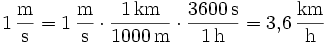
Die Fließgeschwindigkeit "v" errechnet sich aus der ermittelten Zeit "t" und der Breite der Brücke "s" wie folgt: v = s/t. Sende uns dein Messergebnis in m/s zu. Da du es vermutlich gewohnt bist in km/h zu denken, kannst du deine Schätzung auch in km/h umrechnen, indem du das Ergebnis mit 3,6 muliplizierst.
Aufgabe 3: Wasserfallsteig
Bevor du über den Koboldpfad zum Gletscherschliff und weiter in die Geisterklamm gehst, kannst du auf einem abenteuerlichen Steig 200 Meter tief in die engste Stelle der Alten Klamm vordringen und den 23 m hohen Wasserfall bestaunen. Die Alte Klamm ist täglich von 09:00 bis 18:00 geöffnet. Der Eintritt kostet für Erwachsene € 3 und für Kinder € 1. Stelle dich auf der Plattform am Ende der Klamm direkt vor den Wasserfall und mache ein Foto von dir und deinem Team. Wenn du alleine unterwegs bist, oder kein persönliches Bild hochladen möchtest, dann reicht auch jeweils ein Foto auf dem dein GPS mit passendem Hintergrund zu sehen ist, um diese Logbedingung zu erfüllen. Sollte die Klamm geschlossen sein, oder falls du - aus welchen Gründen auch immer - die Klamm nicht betreten willst, dann reicht auch ein Foto auf der nahen Brücke in Richtung Klamm. Weitere Fotos sind natürlich willkommen ;-)
Wieder zuhause sende uns eine kurze E-Mail mit dem Namen deines Teams gemeinsam mit dem Datum, an welchem du die Aufgaben gelöst hast und deiner Antwort zu Aufgabe 2, an folgende Adresse:
AAAAA-BBB-CCCC@mus162.com
"AAAAA-BBB-CCCC" ist ein Platzhalter, den du natürlich erst durch die Antworten auf die gestellten Fragen aus Aufgabe 1 ersetzen musst. Falls deine Antworten korrekt waren, erhälst du sofort eine automatische Logreigabe zurück. Danach darfst du deinen Besuch im Reich der Wasserzwerge loggen. Bitte hänge das obligatorische Foto aus Aufgabe 3 an dein Log an!
Logs ohne Logfreigabe bzw. Fotos werden kommentarlos und ohne Ausnahme wieder gelöscht!
Realm of the Waterdwarfs
During the last 15.000 years the water of the "Leutascher Ache" has dug itself deep into a special kind of limestone called "Wettersteinkalk". The reason for this are ice-age glaciers. The fact that the river has eroded itself deeply into the rock in a geologically short period of time, is proven by the very steep, sometimes overhanging cliffs. This is because the erosion had too few opportunities to mitigate the sharp shapes.
Deep down in the Old Gorge there is the Mittenwald Waterfall Trail. Please do not throw stones or any other objects down into the gorge in this section. in this section of the gorge does not therefore stones or other objects down! You could injure walkers or the waterdwarfs!
Goblins' Hump
At the header coordinates you're standing on the escarpment to the Spirit Gorge at a place which was covered by ice-age glaciers 10.000 years ago. The glaciers went down the edge right in front of you in order to pave their way into the Alpine foreland. Behind you the rounded summits of the "Burgberg" are rising, which was overflown by the glaciers too, and therefore it formed to the Goblin's Hump. The gorge itself was formed during the melting of the ice by massive meltwater streams in a geologically relatively short period of time.
But why are these really stiff acting ice giants able to flow through valleys? We could assume magical powers by the hand of Goblin or Spirits, but it was already recognized over 150 years ago that gravity is the real engine of the movement of glaciers. The flow rate depends on the gradient. It varies from 30 to 250 meters per year for Alpine glaciers. This was quite different during the last ice-age. At that time it was so cold that the glaciers moved only a few meters per year.
There are four major glaciations documented (Günz, Mindel, Riss and Würm). Their youngest, the Würm ice-age, lasted for 100.000 years and ended about 10.000 years ago. This has greatly influenced the present-day glacial landscape of the Alps. At the climax of the ice-age, 22.000 years ago, there existed an ice-sheet with a thickness up to 2.000 meters in the valleys such as the Inn Valley. While the area of all glaciers on the Alps at that time was about 125.000 km², there are barely 3.500 km² remaining.
Logging Conditions
Before you are allowed to log this Earthcache you have to accomplish the following tasks first (you may want to answer the questions below in english):
Task 1: Ice Age Diary
Along the path to the Waterfall Trail within the Old Leutasch Gorge, the waterdwarfs are browsing the Ice Age diary. To distract from the efforts of the steep path, they tell you an episode out of the neverending story of glaciation in the Alps in each serpentine. It started abound 2.4 million years ago, when the beginning of the ice-age changed the life on the northern hemisphere fundamentally. This was also when the latest chapter of the earth begun...
Read the information boards carefully and then answer the following questions:
- The last great period of the Ice Age is named after a tributary of a famous river. Which famous river is meant here? Write down the name of that river as AAAAAA.
- How much did the Venediger Glacier advance in the time of the woolly rhinos and mammoths? Write down the larger one of the two numbers as BBB.
- Around which year did the glaciers reach their last peak expension when the ice sheets were just as long as they were 9.000 years ago? Write down the year as CCCC.
Task 2: The Power of Water
Place yourself on the bridge near the Goblin's Gate, and look westwards. There you recognize the entrance to the Old Gorge, which was formed by the power of water during the Ice Age. Now determine the flow rate of the river below you by throwing a piece of wood into the water. Count the amount of seconds it takes the piece of wood to show up on the other side of the bridge again.
The flow rate "v" is calculated from the determined time "t" and the width of the bridge "s" as follows: v = s/t. Send us your measurement in m/s. Because you may be used to think in km/h, you may also convert your estimation into km/h by multiplying the result with 3.6.
Task 3: Waterfall Trail
Before you proceed your tour on the Goblin's Path to the Glacier-Fluting and then go back into the Spirit Gorge, you may want to walk on an adventurous trail of about 200 meters into the narrowest part of the Old Gorge to see the 23 meter high waterfall at the end. The Old Gorge is open daily from 09:00 to 18:00. The entrance fee for adults is € 3 and for children € 1. Place yourself on the platform at the end of the gorge in front of the waterfall and take a photo of you and your team. If you're traveling alone or you do not want to upload a personal picture, then photos of your GPS receiver with a matching background are also sufficient, to meet the Logging Conditions. If the gorge is closed, or if you do not want to enter the gorge for whatever reason, then take a photo towards the gorge on the nearby bridge instead. More photos are welcome ;-)
Back home send us a brief e-mail with the name of your team together with the date when you've solved the tasks and the answer of task 2 to the following address:
AAAAAA-BBB-CCCC@mus162.com
"AAAAAA-BBB-CCCC" is a placeholder. Of course you have to replace it by the answers to the questions of task 1 first. If your answers were correct you should get an automatic log approval immediately. Then you are allowed to log your visit of Realm of the Waterdwarfs online. Please attach the obligatory photo of task 3 to your log as well!
Logs without a valid log approval or photos will be deleted without exception and comment!