Entstehung der Karstlandschaft:
Gesteine mit einem Gipsanteil von bis zu 98 Prozent kommen in Franken ausschließlich im Gipskeuper vor, einer geologischen Formation, die vor rund 220 Millionen Jahren entstanden ist.
Zu dieser Zeit herrschte hier ein trockenes und heißes Klima, in flachen Buchten stand salzübersättigtes Wasser und dampfte ein. Dabei fielen Gipskristalle aus und lagerten sich am Grund ab, bis eine heute an manchen Stellen 10 m hohe Gipsschicht entstand. Erneute Überflutungen brachten neue Sedimente heran, die sich über dem Grund- und Felsengips ablagerten.
Unter dem Druck immer neuer, überdeckender Gesteinsschichten verlor der Gips Wasser und verwandelte sich in Anhydrit. Anhydrit ist, wie der Gips selbst, ein Calciumsulfat, dem jedoch die beiden Wassermoleküle fehlen.
Gewaltige tektonische Hebungen vor 45 Millionen Jahren und die Erosion der Deckschichten brachte die Anhydritlager wieder in die Nähe der Oberfläche, wo Grund- und Sickerwasser sie erreichten. Der Anhydrit lagerte erneut Wassermoleküle ein und wurde wieder zu Gips.
Die Landschaften am Fuß der Hassberge und des Steigerwaldes werden geprägt vom Gipsgestein, das hier offen zu Tage tritt. Ausgelaugt von Grund- und Regenwasser verkarstet der Gipsfels, so dass eine Karstlandschaft mit unruhigem Bodenprofil entsteht. Eine Karstlandschaft entsteht durch Ausschwemmen von oberflächennahem Gipsgestein durch Grund- und Regenwasser (etwa 2,5 Gramm Gips lösen sich in 1 Liter Wasser).
Die Wasseraufnahme bei der Umwandlung von Anhydrit zu Gips führt zu einer Volumenzunahme und diese wiederum führt zu Faltungen, Rissen und Verwerfungen im Gipsfels. An genau diesen Störungen setzen die Auflösungsprozesse an: Das Wasser vergrößert winzige Risse zu Klüften und Hohlräumen. Labyrinthische Höhlensysteme können auf diese Weise entstehen.
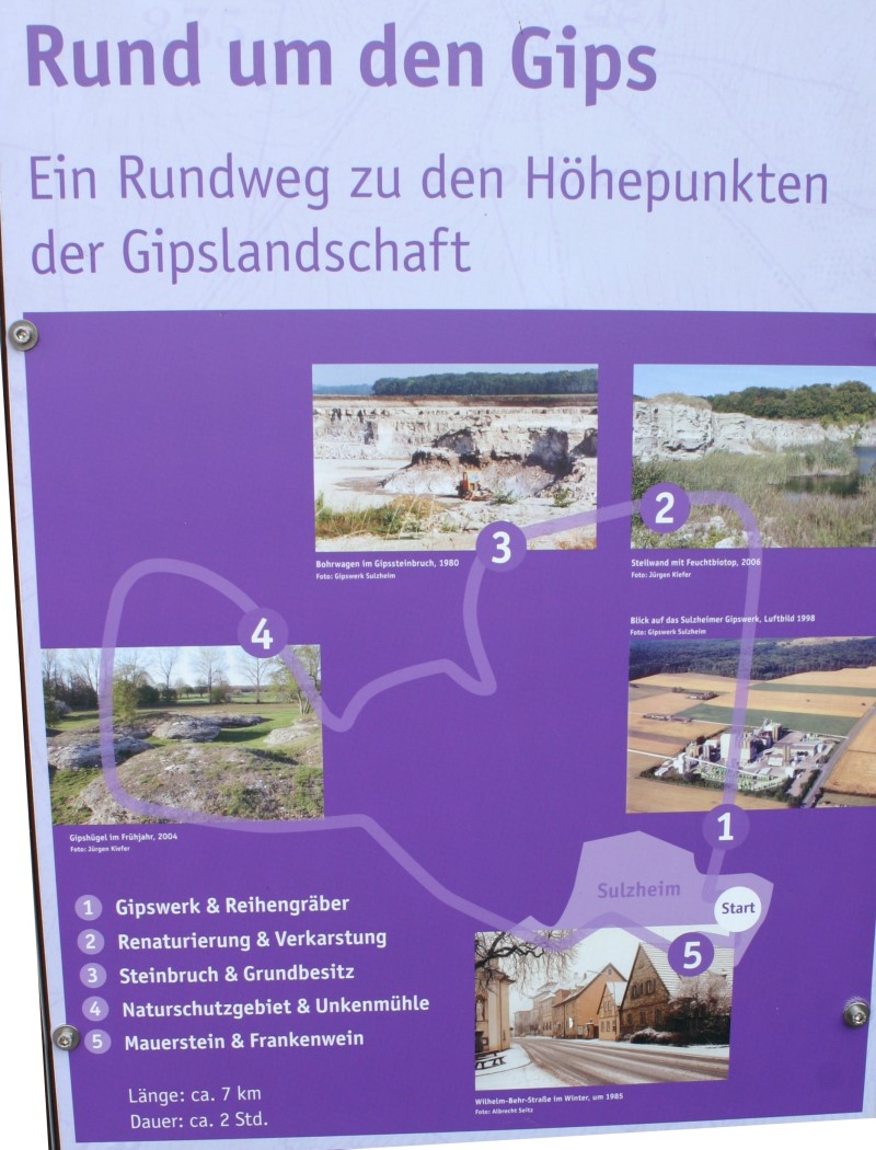
Der Gipswanderweg:
Der etwa 7 km lange Rundweg (muß nicht komplett gelaufen werden, zur Beantwortung der Fragen genügen GIZ, Station 2 und Station3 - siehe Logbedingung) beginnt am Gips-Informationszentrum (GIZ) in Sulzheim mit Außenraum und einer Ausstellung. Der Außenraum und der Rundweg sind jederzeit zugänglich, die Ausstellung ist von April bis Oktober an Sonn- und Feiertagen von 14:00 bis 17:00 Uhr gegen eine geringe Gebühr geöffnet.
Station 1: Das Gipswerk Sulzheim (kann nicht besichtigt werden)
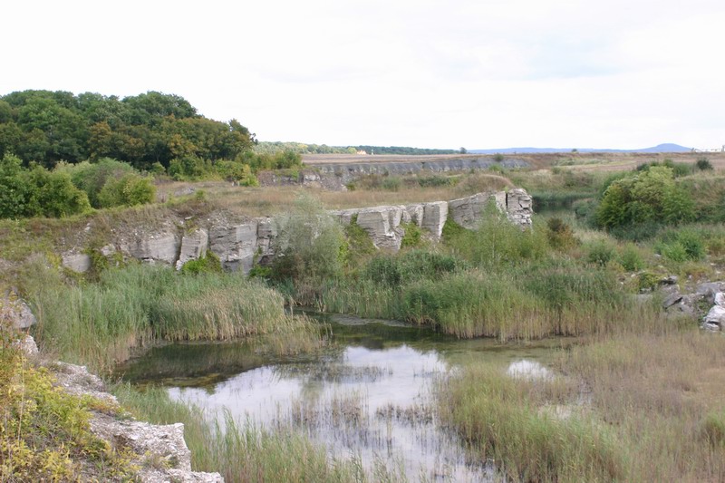
Station 2: Der renaturierte Gipssteinbruch ist eine gezielte Maßnahme des Natur- und Artenschutzes. Hier finden sich steile Wände aus festem Fels ebenso wie Steinhaufen, wechselfeuchte Bereiche oder stehende Gewässer mit ausgeprägten Flachwasserzonen, so dass sich auf engstem Raum die verschiedensten Lebensräume finden. An den Steilwänden ist zudem die Gipsschichtung gut zu erkennen. Der renaturierte Gipssteinbruch ist mittels einer Plattform gut einsehbar.
Im bewaldeten Karstgebiet neben dem Steinbruch gleich hinter der Informationstafel befindet sich die ‚Hollergrube‘ ein Schluckloch, das allerdings nur bei Regen besichtigt werden kann. Das Regenwasser, das im Karst kaum versickern kann, sammelt sich in einem Bachlauf, der in einem Schluckloch endet, das heißt, das Wasser versickert in der dünnen Bodenauflage und fließt unterirdisch durch Felsspalten ab.
Station 3: Im bewirtschafteten Steinbruch findet sich ein 9 bis 10 Meter in die Tiefe gehender, mächtiger Gipsfels. Mehrere so genannte Abbruchsohlen unterteilen ihn horizontal. Der Stein wird durch Anbohren und Sprengung gebrochen und dann zum Gipswerk weiter befördert. Das Betreten des Steinbruchs ist verboten
Station 4: Rund 1,5 km nordwestlich von Sulzheim liegen die Gipshügel. Im Gegensatz zu anderen Verkarstungszonen der Umgebung blieben sie über Jahrtausende hinweg unbewaldet.
Die flachgründigen, der Sonne ausgesetzten Böden des Gipskarstes ermöglichten hier einer Steppenvegetation das Überleben, wie sie in Franken nach dem Ende der letzten Eiszeit einst vielerorts üblich und weit verbreitet gewesen war. Die Gipshügel unterstehen strengem Naturschutz.
Station 5: Häuser in Sulzheim, die aus Gipsgestein erbaut wurden
Logbedingung:
Mach ein Foto von dir auf der Plattform am renaturierten Steinbruch und beantworte folgende Fragen (dazu genügt es, nur den Start und die Stationen 2 und 3 des Rundwegs zu besuchen):
Gips-Informationszentrum: Wie hoch liegt der Gipsanteil des dort in der Außenanlage ausgestellten Gipsfelsens aus dem Steinbruch Sulzheim in etwa?
Station 2: Wie wird die Hollergrube, das Schluckloch neben dem Steinbruch, noch genannt?
Station 3: Aus welchem Jahr stammt das Foto der Gipsgrube Kleinrheinfeld?
Schicke die Antworten per Mail an meinen Account, schreibe in den Betreff deinen/eure Cachernamen.Ihr könnt sofort loggen, wenn etwas nicht stimmt melde ich mich. Ein Foto von euch oder eurem GPS wäre schön.
---------------------------------------------------------------
Origin of the karst landscape:
Rocks with a gypsum portion of up to 98 percent exist in franconia exclusive in the Gipskeuper, a geological formation, which originated in approximately 220 million years ago.
At this time a dry and hot climate prevailed, in flat bays stood salt-surfeited water and evaporated. Gypsum crystals failed and settled at the bottom, until today at some places 10 m high gypsum layer were created. Renewed floodings brought new sediments, which settled on the top of the basic and rock gypsum. Under the pressure of new rock formations the gypsum lost water and transformed into anhydrite. Anhydrite is, like the gypsum, a calcium sulfate, with two water molecules less. Enormous tectonic elevations 45 million years ago and the erosion of the surface layers the anhydrite brought back into the proximity of the surface, where groundwater and percolating water reached it. The anhydrite stored again water molecules and became again gypsum.
The landscapes at the foot of the ‚Haßberge’ and the ‚Steigerwald’ are shaped by the gypsum rock, which lays here near to the surface. Leached out of ground and rain water the gypsum rock karstified, so that a karst landscape with jerky soil profile develops. A karst landscape results from washing out the gypsum rock near the surface by ground and rain water (about 2.5 gram gypsum separate in 1 litre water). The water absorption during the transformation from anhydrite to gypsum leads these to an increase of volume and again leads to foldings, tears and distortions in the gypsum rock. At exactly these disturbances the dissolution processes starts: The water increases tiny tears to gaps and cavities. Labyrinthic cave system can be developed in this way.
The gypsum walking way:
The about 7 km long round way begins at the gypsum information center in Sulzheim with an outside space and an exhibition. The outside space and the round way are at any time accessible, the exhibition is opened from April to October at Sundays and bank holidays from 2:00 pm to 5:00 pm (a small fee has to be paid).
Station 1: the gypsum works Sulzheim (cannot be visited)
Station 2: The renaturated gypsum quarry is a purposeful measure of nature and protection of species. Here steep walls from firm rock are just like heaps of stone, alternating-wet ranges or standing waters with pronounced shallow water zones, so that on closest area the most diverse habitats can be found. At the steep walls the gypsum layering can be recognized very well. The renaturated gypsum quarry is well observable by means of a platform. In the wooded karst area besides the quarry equal behind the information board is ‚the Hollergrube‘ a sip hole (Schluckloch), which can be noticed however only when it’s raining. The rain water, which can hardly seep in the karst, collects itself in a brook run, which ends in a sip hole, i.e., the water seeps in the thin ground edition and flows off underground by rock columns.
Station3: In the managed quarry you can find 9 to 10 meters deep gypsum rock. It is devided into several demolition layers. The stone is broken by drilling and denotation afterwards it is carried to the gypsum works. Entering of the quarry is forbidden
Station 4: Approximately 1.5 km northwest from Sulzheim lie the gypsum hills. Contrary to other karst development zones they remained nonforested over thousands of years. The raft footing, the sun suspended grounds of the gypsum karst made here a surviving for a steppe vegetation possible, how it could be found at many places after the end of the last ice age in franconia. The gypsum hills are strict nature protected.
Station 5: Houses in Sulzheim, which were built from gypsum rock
Log condition:
Make a photo of you on the platform at the renaturated quarry (station 2 of the gypsum walking way) and answer the following questions (it is sufficient to visit only the start and the stations 2 and 3 of the round way):
Gypsum information center: How high is the gypsum portion of the rock from the quarry Sulzheim in front of the gypsum information center in percent (approx.)?
Station 2: How is the Hollergrube, the sip hole (Schluckloch) besides the quarry, also called?
Station 3: At which year was the photo of the gypsum quarry ‚Kleinrheinfeld’ taken?
Send the answers by mail to me. You can log the cache directly, if there are questions i will contact you. A photo of you or your GPS would be nice.