Kali Gandaki Trek #9 : River of Ammonites EarthCache
Kali Gandaki Trek #9 : River of Ammonites
-
Difficulty:
-

-
Terrain:
-

Size:  (other)
Please note Use of geocaching.com services is subject to the terms and conditions
in our disclaimer.
Altitude : 2908 m
Hello Cachers,
on our track through the Kali Gandaki gorge we saw so many interesting places that we decided to publish some of them as earth cache. Please feel free to download our gpx track (Garmin notation, ZIP archieve) here.
Introduction
Mustang
This trek guids you through Mustang and especially Upper Mustang, also known as Lo or "The last forbidden kingdom". It was an independent buddhistic kingdom until the end of the 18th century. As a district of Nepal it was an autonomous teritory and forbidden for any foreign people. The kings own the title "Raja". The last Raja, Jigme Palbar Bista, lives now in Lo Mantang. With the end of the Nepal monarchy in late 2008 also Jigme Palbar Bista lost all his titles. Mustang was opened for foreigners in 1992. To read more about Mustang please see here.
Kali Gandaki
The Kali Gandaki River (also Narayani, Gandak) is one of the major rivers of Nepal. It is known as the river with the deepest gorge in the world. The river flows between the mountains Dhaulagiri (8167 m) to the west and Annapurna (8091 m) to the east. The gorge begins at Kagbeni. The river flows southwards to Jomsom, Marpha and Tukuche. The deepest part of the gorge is in the area of Lete (see Kali Gandaki #3). The gorge then broadens past Dana and Tatopani towards Beni. The Kali Gandaki gorge has been used as a trade route for centuries. Today, it is part of a trekking route from Pokhara to Muktinat and belongs to the 'Annapurna Circuit'. The gorge is within the Annapurna Conservation Area (trekking permit!). The Kali Gandaki rises in the Tibetan plateau north of the Himalayas in the Mustang District of Nepal, close to the tibetian border. The two headwaters of river, Nup Chhu and Shar Chhu ("West River" and "East River") meet near the town of Lo Manthang in upper Mustang. The river then flows southwest with the name of Mustang Khola. In Kagbeni Kak Khola, coming from Muktinath, meets Mustang Khola; from there, the river is called the Kali Gandaki. To learn more about the Kali Gandaki please read here.
The Himalayas
The Himalayas belong to the youngest mountains on the planet. They consist mostly of uplifted sedimentary and metamorphic rock. According to the modern theory of plate tectonics, their formation is a result of a continental collision between the Indo-Australian Plate and the Eurasian Plate. This is referred to as a fold mountain.
The collision began in the Upper Cretaceous period about 70 million years ago. At this time the Indo-Australian Plate was moving at speed of about 150 mm per year (today ~67 mm ). This leads to the Himalayas rising by about 5 mm per year, making them geologically active. About 50 million years ago, this fast moving Indo-Australian plate had closed the Tethys Ocean and the growing mountains lift up its marine sediments. To learn more about the Himalayas please read here.
To understand what you will see on the treck, please keep in mind that:
- Kali Gandaki is a very old river, older than the Himalayas
- so Kali Gandaki deposits sediment before the mountains grow
- it cuts its gorge through a growing mountain
- valleys are filled up with river sediment, sand by wind and erosion of mountain walls
- at some places (very often the edge of the Tethys ocean) you find vulcanic hot spots caused by deep magmatism
- the Himalayas cut off the prehistoric ocean Thetys and lift up marine sediment
River of Ammonites
Fossils are the preserved remains or traces of animals, plants, and other organisms from the remote past. A fossil normally preserves only a portion of the deceased organism, usually that portion that was partially mineralized during life, such as the bones and teeth of vertebrates, or the chitinous exoskeletons of invertebrates. Fossil sites with exceptional preservation are known as 'Lagerstätten'. These formations may have resulted from carcass burial in an anoxic environment with minimal bacteria, thus delaying decomposition. Here, in the area of Tetang and Muktinath, is the location of a 'Lagerstätte', found inside the soft Tethys ocean sediment layers. Kali Gandaki and its tributary streams wash the fossils out of the sediment and transports them over a long distance.
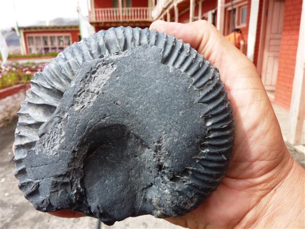
Ammonites are an extinct group of marine animals belonging to the cephalopod subclass Ammonoidea. They are excellent index fossils, and it is often possible to link the rock layer in which they are found to specific geological time periods.The closest living relative of the Ammonitida, is not the modern Nautilus which they somewhat outwardly resemble, but rather the subclass Coleoidea (octopus, squid, and cuttlefish). Their fossil shells usually take the form of planispirals. Ammonites existed from the devonian (416 – 359 mio. years) until the tertiary (~ 65 mio. years). They form about 1500 generas with 30.000 to 40.000 species. The size of ammonites varies from less than one cm up to 2 meters.
Ammonites are very common in Nepal. They are holy/sacred remains for Budhist and Hindu people and you can buy them in more or less any souvenir shop. Around Muktinath and Tetang they are collected by local people. Here you can find them yourself:
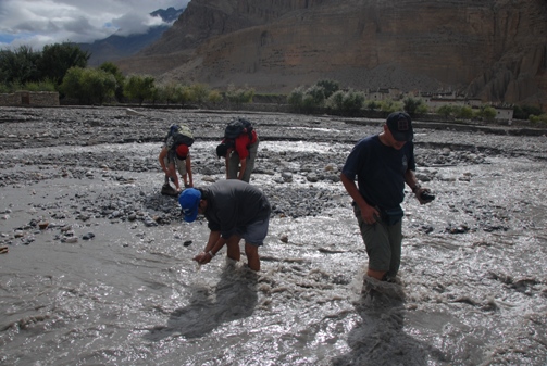
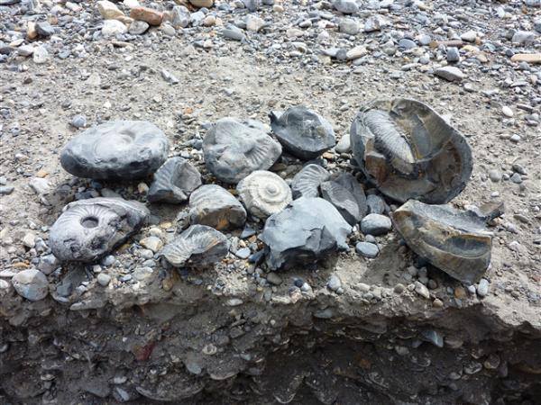
The Tetang river transports a lot of spheric shaped, very hard black stones. Some of them contain ammonites. Sometimes you can see parts of the fossil or you have to crack some stones.
To log this cache:
About pictures of you at the location we would be very happy.
- find your own ammonite and add a photo if it to your log
Write us an email and answer the following question:
Many fossils found here in Tetang show a golden color or gloss.
a) What is the name of this material?
b) Try to find out why is it found (always) on the fossil and not somewhere in the stone?
c) Add a foto from nearby that proofes your visit. Please do not spoil geological features!
Greetings
Rheinflut1995 and Gamelan
Additional Hints
(No hints available.)