Version
Française :
- Historique :
Dom-le-Mesnil est une petite ville située entre
Charleville-Mézières et Sedan, sur la rive gauche de la Meuse. Les
habitants de Dom-le-Mesnil s'appellent les Domois et les Domoises
et sont au nombre de 1100 environ.
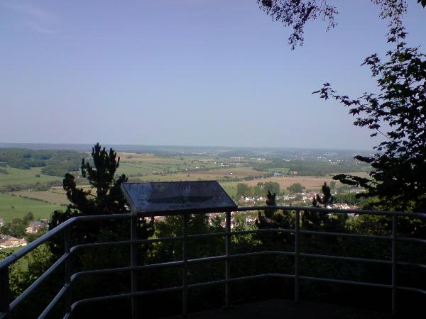
Le point de vue de la Côté de Dom, situé à 267
mètres d’altitude, offre une vue dégagée sur plus de 20 km.
On peut y voir une multitude de villes et de villages ainsi que le
fleuve de la Meuse. En Mai 1940, celui-ci sert de principal
observatoire au 3ème bataillon du 148ème Régiment
d’Infanterie de Forteresse. Le fortin sur lequel est
installée aujourd’hui la table d’orientation à été
construit en 1936.
- Informations complémentaires
:
Pour se rendre à l’endroit de la cache, il
est possible de garer son véhicule à quelques mètres du fortin, sur
un petit espace devant une table de pic-nic, situé en N
49°41.130’ - E 004°47.832’. Le point de vue, à
ne pas rater, se situe à quelques pas de cet espace, en N
49°41.135’ - E 004°47.838’. Attention à ne pas
être aperçu à l’endroit de la cache qui se trouve un peu plus
loin car il y a parfois des promeneurs.
English
Version :
- History :
Dom-le-Mesnil is a little town located between
Charleville-Mézières and Sedan, on the left bank of the Meuse. The
inhabitants of Dom-le-Mesnil are called the Domois and Domoises and
are among approximately 1,100.
The point of view of Dom-le-Mesnil, located at
267 meters above sea level, offers a clear view on more than 20 km.
It is possible to see a multitude of towns and villages and the
river of the Meuse. In May, 1940, it serves as the main observatory
of the 3rd battalion of 148th Infantry Regiment of Fortress. The
fort which is now home to the orientation table was built in
1936.
- Additional information
:
To get to the location of the cache, it is
possible to park his vehicle a few meters from the fort, on a small
space with a table to pic-nic, located in N
49°41.130’ - E 004°47.832’. The point of view,
not to be missed, is located just near of this space, in N
49°41.135’ - E 004°47.838’. Be careful not to
be seen at the location of the cache even if it is located a little
further because there are sometimes ramblers.