Peitinger Pechkohle EarthCache
-
Difficulty:
-

-
Terrain:
-

Size:  (not chosen)
Please note Use of geocaching.com services is subject to the terms and conditions
in our disclaimer.
Pechkohleflöz Nr. 2
English description below
Geschichte
Am Lech bei Peiting liegen umfangreiche Kohlevorkommen, die in der
Tertiär-Zeit vor 24 bis 36 Millionen Jahren entstanden sind. Zu
dieser Zeit lag Peiting am Randbereich eines flachen tropischen
Molassemeeres. Durch das ständige Vor- und Zurückweichen des
Uferstreifens und den damit verbundenen Ablagerungen
(„Cyrenenschichten“) am Küstenbereich des Meeres, wurden die in
großer Menge anfallenden Pflanzenreste schnell mit Feinsedimenten
zugedeckt und verrotteten deshalb auch nicht. Aus ihnen entstand im
Verlauf von Jahrmillionen die sogenannte „Pechkohle“. Allerdings
verhinderten die unruhigen Bedingungen die Bildung von
gleichmäßigen Kohleschichten („Flözen“). Die Kohleablagerungen sind
daher nur weniger als einen Meter breit, wie wir auch bei unseren
Geotop sehen werden.
Bei der „Pechkohle“ handelt es sich um eine besondere Art der
Braunkohle, die durch verschiedene geologische Prozesse wie
extremen Druck oder hohe Temperatur bei der Entstehung der Alpen
aus organischer Substanz umgewandelt wurde. Aufgrund des dadurch
weit fortgeschrittenen Prozesses (Inkohlungsprozess) liegt der
Heizwert der Kohle mit cirka 5500 Wärmeeinheiten deutlich über den
sonstigen Braunkohlen.
Die „Pechkohle“ leistet somit lange Zeit einen wesentlichen Beitrag
zur Energieversorgung in Oberbayern. Am Bühlach bei Peiting wurde
im Rahmen von Straßenbauarbeiten ein Kohleflöz freigelegt, der
heute ein wichtiges Zeugnis zur Erdgeschichte darstellt.
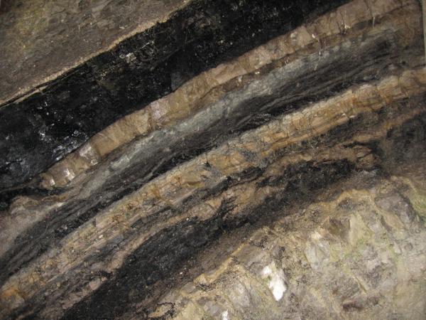
Vor Ort sehen wir eine nachgebaute Schachtanlage aus der Zeit der
Peitinger Bergbaugeschichte. Im dahinter liegenden
„Stollenmundloch“ ist das nach Süden einfallende „Kohleflöz 2“
dargestellt. Es besteht aus mehreren Kohlelagen, die durch
Tonmergel und Stinkstein, einen bitumenreichen und gelblichen
Kalkstein, voneinander getrennt sind. Darunter liegen graublaue
Feinsedimente mit den typischen Fossilien. Alle Schichten und
Zusammenhänge werden ausführlich vor Ort erklärt.
Aufgabenstellung
Hier die Fragen, die vor dem Eintrag zu beantworten sind:
1. Wieviel Flöze wurden im oberbayerischen Kohlerevier systematisch
identifiziert?
2. Wann wurde dieses Geotop entdeckt?
3. Das Peitinger Pechkohle Geotop wurde von Dr. Werner Schnappauf
mit dem Gütesigel „Bayerns schönste Geoptope“ ausgezeichnet. Wann
war das und welche Rahmenfarbe hat die Urkunde, die Ihr vor Ort
vorfindet?
Für den Eintrag benötigt Ihr weiterhin ein aktuelles Foto von Euch
zusammen im Zusammenhang mit der „Peitinger Pechkohle“.
Das Geotop ist ab Peiting ausgeschildert („Geologie erleben“).
Informationen zu allen Fragen findet Ihr bei N 47°47.273‘
E010°57.302‘. Die Frage 3 kann nur vor Ort gelöst werden.
Viel Spaß an eines von Bayerns
schönsten Geotopen,
RedSun
(please look at picture 1 „Pechkohleflöz Nr. 2")
History
Extensive coal occurrences which arose in the tertiary-time in
front of 24 to 36 million years are due to the Lech at Peiting. At
this time Peiting lay near the guard zone of a flat tropical
molasse sea. Through the continuous one before- and withdrawing of
the bank strip and the deposits connected with that
(“Cyrenenschichten”) at the coast field of the sea, the shives
pending in great amount were covered quickly with detailed
sediments and did not rot therefore either. The so-called
„Pechkohle arose from them during year millions. However, the
restless conditions prevented the formation of regular carbon films
(„Flözen). The coal deposits are only less than a meter broad from
that, as we also at ours Geotop will see.
At the „Pechkohle it is a question of a special kind of the brown
coal which was converted by different geological processes as
extreme pressure or high temperature during the formation of the
alps from organic substance. Due to the process through that far
advanced (“Inkohlungsprozess”) the net calorific value of the coal
lies with about 5500 heat units clear above the other brown coals.
The „Pechkohle achieves thus long time an essential contribution to
the energy supply in upper Bavarians. At the Buehlach at Peiting
which represents an important report for the geology today a coal
seam was laid open within the framework of road construction jobs.
On site we see a reproduced pit from the time of the Peitinger
mining industry history. In the „Stollenmundloch” lying behind that
the „Kohleflöz 2” incident to south is represented. It consists of
several coal situations which are separate through clay marl and
stinkstone, a bitumen-rich and yellowish limestone, of each other.
Under that grey blue detailed sediments with the typical Fossils
lie. All shifts and connections are explained fully on site.
Setting of a task
Here the questions that are to be answered before the entry:
1. How much seams were identified in the upper-Bavarian coal
district systematically?
2. When was this Geotop discovered?
3. The Peitinger jet Geotop was characterized most beautiful
Geoptope from Dr. Werner Schnappauf with the kindness hedgehog
Bayerns. When was that and which frame color has the document that
you find on site?
You keep on needing a current photograph of You for the entry
together in connection with the „Peitinger Pechkohle.
The Geotop is from Peiting signposted („Geologie erleben). You find
information on all questions at N 47°47.273' E010°57.302'. The
question 3 can be solved only on site.
A lot of fun onto one of Bavaria
most beautiful Geotopen,
RedSun
Additional Hints
(No hints available.)