En direction du belvédère
FRANCAIS
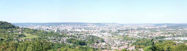
Cette multi vous offre la possibilité de vous ballader dans la foret de Ludres et de découvrir un belvédère offrant une belle vue sur Nancy et ses environs
STAGE 1 : N 48°37.748 E 06°10.097
Par quel symbole est balisée la direction du belvédère?
- A = 1 : un triangle vert
- A = 2 : un carré rouge et jaune
- A = 3 : un rond bleu
STAGE 2 : N 48°38.334 E 06°09.845
De quelle couleur est la borne marquant l'intersection du chemin?
- B = 7 : blanche avec 3 rayures rouges
- B = 8 : jaune avec des ronds noirs
- B = 9 : bleue avec des triangles verts
STAGE 3 : N 48°38.446 E 06°10.144
Profitez de la vue tout en cherchant:
- CD : la distance en km jusqu'à la ville de Metz
- WXYZ : l'altitude du Donon en mètres
FINAL : N 48°AZ.A(D+W)(C+D) E XY6°09.9DB, la table d'orientation n'existant plus, voila les coordonnées du final : N 48° 38.337' E 6° 9.927'
Pensez à bien remettre la cache dans l'état où vous l'avez trouvé ;-) Merci
Bon geocaching - Jeremysme et Lauriane
ENGLISH
This multi allows you to walk in the forest of Ludres and discover a nice point of view around Nancy.
STAGE 1 : N 48°37.748 E 06°10.097
With which symbol is the direction to the point of view marked?
- A = 1 : a green triangle
- A = 2 : a red and yellow square
- A = 3 : a blue circle
STAGE 2 : N 48°38.334 E 06°09.845
Of which color is the signpost which marks the new path to follow?
- B = 7 : white with 3 red stripes
- B = 8 : yellow with black circles
- B = 9 : blue with green triangles
STAGE 3 : N 48°38.446 E 06°10.144
Enjoy the view and search for:
- CD : the distance in kilometers to the city of Metz
- WXYZ : the altitude in meters of the moutain called Donon
FINAL : N 48°AZ.A(D+W)(C+D) E XY6°09.9DB, the table has been removed, so the final coordinates are: N 48° 38.337' E 6° 9.927'
Please replace the cache in the same state you found it ;-) Thanks
Happy geocaching - Jeremysme and Lauriane