Miners Castle Sea Cave EarthCache
-
Difficulty:
-

-
Terrain:
-

Size:  (not chosen)
Please note Use of geocaching.com services is subject to the terms and conditions
in our disclaimer.

Pictured Rocks National Lakeshore is America's first National Lakeshore, established by the 89th Congress of the United States on October 15, 1966. There are opportunities for many recreational activities thanks to the development of trails, campgrounds and roads in and around the Lakeshore’s boundaries. Pictured Rocks National Lakeshore has two gateways – Grand Marais at the eastern edge and Munising at the west. Sleeping Bear Dunes, The Apostle Islands and Indiana Dunes are the three other national lakeshores that were authorized in subsequent years.
Permission for this Earthcache was granted by the Pictured Rocks National Lake Shore Park Service because of Earthcache’s Leave No Trace principles, and the fact there is no placement of any physical cache container. Having a cache container placed anywhere within any National Park Service boundaries is strictly prohibited.
Munising Falls, Mosquito Beach, Grand Sable Dunes – A Perched Dune, Miners Castle, Miners Falls and Pictured Rocks View are the other Earthcaches currently available at this Lakeshore.
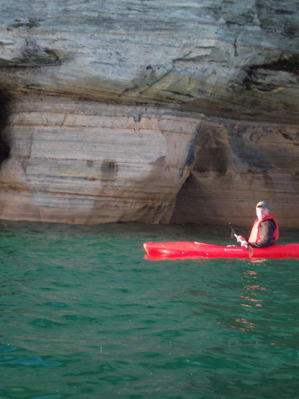
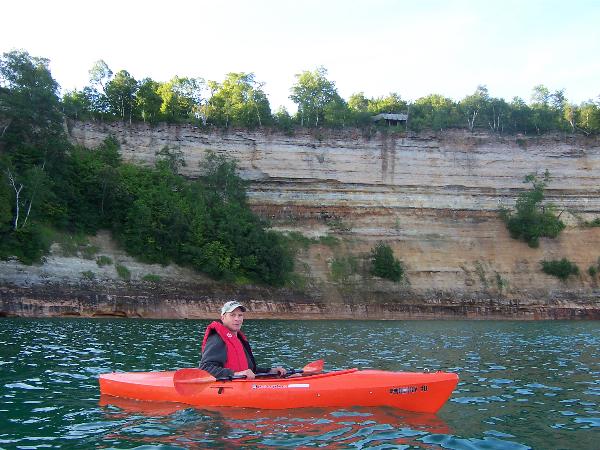
 I must stress that this earthcache is only accessible by a water craft via lake superior. If you are not comfortable navigating the waters of lake superior, do not attempt to do this cache. Lake Superior can be dangerous at times for small water craft such as kayaks or canoes. Before attempting this Earthcache, use common sense and a few safety procedures, such as telling someone where and what you will be doing and wearing a life jacket. Continually monitor the weather conditions as they may suddenly change and there are a limited number of take out points along the 12 miles of cliffs. It is strongly suggested you research your trip. Choose a day when the winds are calm. I put my kayak in the water at miners beach which was 0.13 miles from the posted coordinates.
 During your visit to the Pictured Rocks National Lakeshore you will have the opportunity to see three prominent natural features. The Grand Sable Dunes on the eastern end of the Lakeshore, miles of pristine sand beaches in the middle third and Lakeshore’s name sake – the multi-colored sandstone cliffs – on the western end. Geological history recorded in the sedimentary rocks and surficial deposits of Pictured Rocks National Lakeshore is limited to two widely separated intervals of geologic time, the Late Precambrian, Cambrian, and Early Ordovician Periods (500-800 million years before present) and the Late Quaternary Period (two million years before present to the present).
 During the Cambrian and Early Ordovician periods, sediments were deposited in the shallow seas and near-shore deltas that covered what is now northern Michigan. These deposits became the sandstone units that are exposed within the Lakeshore. Except for their exposure near Lake Superior, these units are presently covered by a veneer of Quaternary glacial drift.
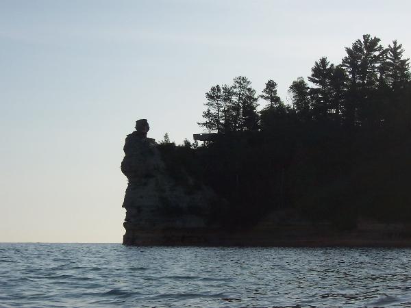
Bedrock is best observed in the western one-third of the Lakeshore where cliffs rise up to 180 feet from Lake Superior. These extend along the lake about 17 miles from Munising to Beaver Basin. For a short distance inland from the escarpment, bedrock is occasionally exposed.
Ice sheets of all four North American glacial stages advanced and retreated through the area during the Pleistocene epoch. A brief re-advance of ice occurred 10,000 years ago in northern Upper Michigan. Melting of glacial ice within the Superior Basin produced huge rivers that deposited millions of tons of pulverized rock rubble in various configurations to the south of the Superior basin. A sheet of outwash, of varying thickness, was deposited along the south edge of Pictured Rocks National Lakeshore. Meltwater carved several channels into Cambrian sandstone bedrock.
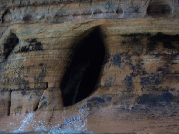
The best way to fully appreciate The Pictured Rocks is from the water. The cliffs rise majestically from Lake Superior showing their brilliant colors as the sun shifts in the sky. Sandstone cliffs of ochre, tan, and brown - sandwiched with layers of white, green, orange, and black - glisten against the cloud-streaked sky and clear waters of Lake Superior. Where the lake meets the cliffs, many sea caves have been carved out by the lake’s powerful, pounding force. The sea caves at the base of Miners Castle are the subject of this EarthCache.
 Miners Castle Sea Caves
Sea caves are formed by the power of the ocean (or in some cases, lakes) attacking zones of weakness in coastal cliffs. The weak zone is usually a fault, or fractured zone formed during slippage. Another type of weak zone is formed where dissimilar types of rocks are inter-bedded and one is weaker than the other. Typically this is a dike, or intrusive vein of more easily eroded rock found within a stronger host rock. Yet a third instance is in sedimentary rocks where a layer of softer rock is inter-bedded between harder layers. The cave may begin as a very narrow crack into which waves can penetrate and exert tremendous force, cracking the rock from within by both the weight of the water and by compression of air. Sand and rock carried by waves produce additional erosive power on the cave's walls.
There are four logging requirements for the Miners Castle Sea Caves EarthCache.
First: Post with your log your picture of you, holding your gpsr, with the Miners Castle sea caves behind you. Your picture should have the entire height of the cliff from the water to the top of Miners Castle (optional).
Second: In your log state the air and water temperatures and the time of your visit. When I visited the site, on July 14, 2009, the water temperature was 54° Fahrenheit and the air temperature was 41° Fahrenheit at 7:00 am. Go to the National Buoy Data Center’s Buoy 45004 in Lake Superior. Compare your readings to the buoy’s reading on the day and approximate time of you visit. (ATMP = air temp. and WTMP = water temp). Click on the icon at the top of the column for a five day history) Email me the following information:
Third: Estimate the height of the tallest sea cave at the base of Miners Castle. Email me your estimate.
Fourth: Use your gpsr to determine Lake Superior’s elevation at the posted coordinates. As you are facing Miners Castle you can see the Upper Viewing Platform at the top of the cliffs to the west. Its elevation is approximately 775 feet above sea level. Subtract the lakes level from 775 to determine how high the cliff rises from the water.
Edited by the one and only LOST SCOUTS
Additional Hints
(Decrypt)
Or cercnerq naq purpx gur jrngure sberpnfgf. abnn.tbi vf n terng cynpr gb cercner sbe lbhe gevc. Uhtr gunaxf gb gur bar naq bayl YBFG FPBHGF sbe gurve uryc va rqvgvat guvf pnpur cntr.