The Tropic of Capricorn lies at 23.5° South of the equator and runs through Australia, Chile, southern Brazil (Brazil is the only country that passes through both the equator and a tropic), and northern South Africa.
The tropics are the two lines where the sun is directly overhead at noon on the two solstices - near June and December 21. The sun is directly overhead at noon on the Tropic of Cancer on June 21 (the beginning of summer in the Northern Hemisphere and the beginning of winter in the Southern Hemisphere) and the sun is directly overhead at noon on the Tropic of Capricorn on December 21 (the beginning of winter in the Northern Hemisphere and the beginning of summer in the Southern Hemisphere). The area bounded by the Tropic of Cancer on the north and Tropic of Capricorn on the south is known as the "tropics." This area does not experience seasons because the sun is always high in the sky. Only higher latitudes, north of the Tropic of Cancer and south of the Tropic of Capricorn, experience significant seasonal variation in climate. While the equator divides the earth into Northern and Southern Hemispheres, it is the Prime Meridian at zero degrees longitude and the line of longitude opposite the Prime Meridian (near the International Date Line) at 180 degrees longitude that divides the earth into the Eastern and Western Hemispheres. The Eastern Hemisphere consists of Europe, Africa, Asia, and Australia while the Western Hemisphere includes North and South America. Some geographers place the boundaries between the hemispheres at 20° West and 160° East so as to not run through Europe and Africa.
Where is it?
All of us who have looked at a map have noticed a little dotted line called the Tropic of Cancer. In fact, here in the UAE, this little dotted is on the way to Liwa Oasis. But what is it, and what if anything does it have to do with Cancer? The answer is both simple and complicated. The simple answer is that the Tropic of Cancer is 23.5 degrees north latitude. So what? The real answer is a bit more complicated, and very interesting.
Some History
Back in the old days, before television, cellular phones, and the internet, people who had a lot of free time on their hands used to look up at the stars and the sky. They noticed a bunch of remarkable things. One of the things they noticed was that the sun and the stars did not appear in the same place at the same time every day. In the northern hemisphere, from winter until summer, the sun gradually rose higher and higher in the sky each day, while from the summer until winter, the opposite happened. By carefully measuring how high the sun rose at mid day, they discovered that around June 21 (in our current calendar, but that is another story) the sun got as high as it was ever going to get, and that around December 21 the sun stayer lower in the sky than on any other day. To make matters worse, how high and how low the sun gets depends on where you live. For the folks living near the equator, on June 21 the sun was up in the northern sky, their day was long and hot, but things cooled off at night, while for the folks living up near the north pole, the sun was to the south and moved in a small circle. In fact they were in the middle of 6 months of constant daylight. Something funny is clearly going on.
What's the right question?
Suppose we ask the question, when is the sun directly overhead, that is, if we look straight up, when will we see the sun. Another way of asking this question is if we put a stick in the ground, sticking straight up, when will it cast absolutely no shadow. The answer is different depending upon where you live. If you live at the north pole, the answer is never, while if you live near the equator, the answer is twice a year, right around March 21 and September 22. However, if you live at the Tropic of Cancer, anywhere on the world at 23.5 degrees north, the answer to this question is that the sun is directly overhead only once a year, right around June 21st. Anyone living north of the Tropic of Cancer will never see the sun directly overhead, while anyone living south of the Tropic of Cancer (in the northern hemisphere) will see the sun directly overhead exactly twice. We live almost exactly on this dividing line.
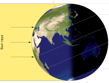
Since a picture is worth a thousand words, take a look at the diagram above for exactly what is going on on June 21st. Our north pole is inclined by 23.5 degrees to the plane that contains the Earth's orbit around the sun. The equator and the line through the poles are at right angles, and the plane of the Earth's orbit around the sun makes an 23.5 degree (what a co-incidence) angle with the equator. Thus the Tropic of Cancer is the northernmost place in the world where the sun is ever directly overhead. Now only one mystery remains. What does this particular latitude have to do with Cancer. Well, it turns out that on June 21st, if you look up at night you will find the sun passes through constellation of Sagittarius. However, if you lived around 2000 years ago and looked up into the night sky you would find that the path of the sun that day took you right through the constellation of Cancer. Since the ancients had the privilege of naming things, this particular latitude is know as the Tropic of Cancer instead of the Tropic of Sagittarius. The next question is, why did it change? Perhaps you can post that in your log?
(Acknowledgements: http://www.maztravel.com/maz/explain/cancer.html )
Earth's Magnetic Field
Earth is like a giant magnet with a North and South Pole. However, the magnetic North and South Pole are not aligned with the Geographic North and South Pole. The Geographic North Pole is defined by the latitude 90° N and is the axis of the Earth's rotation. Latitude and longtude are based around this true (or geographic) North.The Magnetic North Pole is where the Earth's magnetic field points vertically downward. The Earth creates its own magnetic field from the electric currents created in the liquid iron-nickel core.
Compass needles point in the direction of the magnetic field lines, which is generally different from the direction to the Geographic North Pole. The compass pointing direction can also differ from the direction to the Magnetic North Pole since the magnetic field lines are not just lines connecting the magnetic poles like lines of longitutde, but a field that differs according to position. It is important to know the magnetic declination when using a compass to navigate so that the direction of True North can be determined.

Notable Features:
The magnetic poles slowly move with time
The pointing direction of the compass needles and the magnetic declination vary with time due to changes of the Earth's magnetic field
Since the 1970's the Magnetic North Pole has accelerated from less than 10 to more than 30 miles per year. In this part of the UAE - the Magnetic declination shifts about 3' eastward every year. This means that each year the gap between True North and Magnetic North is growing by 3'. So in a 20year period - at the same rate of movement - the declination will change a further degree.
In order to substantiate your visit and be able to claim this Earthcache, a number of questions need to be answered and submitted to the cache developer, via e-mail.
You must also post a photograph on the site with your log of you or your team and GPSr standing near GZ. [optional]
1. Explain Magentic declination (i.e. why magnetic north and true (or geographic north) differ from each other.
2. Look at the surrounding geology as you drive too and from the cache site. If you had been using a magnetic compass. What features may influence your campass readings in the area surrounding the location?
3. The change in magnetic declination is 3' East per year. Given that the magnetic declination at this point was 1 degree 6' East of North on 1 January 2000. Calculate the current magnetic declination.
4.Look at the dunes – do your think they were originally placed by water or wind action? Why do you think this?
5. Describe in your own words what the nearby dune landscape looks like. Especially mention the 2 colurs visible on the dunes and describe why you think there are 2 shades visible.
6. Explain what the centre of the Earth is like (think of the and why this may cause a magnetic field. Very simple answers are needed only.
NOTE: You may log your visit prior to approval, but e-mail submissions that do not meet the above criteria will be deleted.