Vermoorungen haben sich im
Solling besonders dort entwickelt, wo Molkenböden, geringe
Hangneigung und eine Wasserspeisung aus Quellen zusammentrafen.
Dann bildete sich ein Quellmoor, das oft von der Wasserschüttung
darunter liegender Schicht- und Sickerquellen ernährt wird. Das
Wasser durchströmt den Torf; die Quelle selbst ist nur durch
Spezialuntersuchungen auffindbar. Hangmoore entstehen durch
hangabwärts laufendes Wasser und schließen meist nahtlos an die
Quellmoorbereiche an. Die ältesten Torfe im Solling sind ca. 7800
Jahre alt.
Moorwachstum
über »Molke«
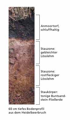
Im Solling kommen besondere Stauwasserböden auf den Hochflächen
vor. Sie zeichnen sich durch eine besonders starke Bleichung mit
milchig-weißer Farbe aus. Die »Molkenböden« sind Stagnogleye, die
sich im Solling über einer abdichtenden tonreichen Fließerde
bilden, wo sie von einer dünnen Schicht Lösslehm überlagert ist.
Beide Schichten sind eiszeitlichen Ursprungs. Fast ganzjährig nasse
Verhältnisse auf den Plateaulagen im Solling führen zur Lösung von
Metall-Ionen in diesen Böden. Gelöstes Eisen und Mangan wird nicht
nach unten, sondern seitwärts mit der Bewegung des Bodenwassers
abtransportiert. Übrig bleibt die reduzierte Eigenfarbe des
Sediments - und die ist bei Lösslehm weißlich. Die Molkenböden
bieten nährstoffarme, schlechtwüchsige Standorte und sind die
Ausgangslage für Vermoorungen.
Ursprünglich gab es
im Solling rund 1200 Hektar Waldmoore. Diese Areale wurden jedoch
in den vergangenen Jahrhunderten nach und nach entwässert. Die
niedersächsischen Landesforsten haben im Solling die Renaturierung
mehrerer Waldmoorgebiete fortgesetzt. Zwei besondere Projekte sind
der Heidelbeer- und der Friedrichshäuser Bruch.
Heidelbeerbruch
Der Heidelbeerbruch ist ein Quell- und Hangmoorkomplex mit 3
– 5 % Gefälle über Buntsandstein-Fließerden. Die Torfe sind
zu dünner Anmoorauflage degeneriert bis teilweise gänzlich
verschwunden. Nur noch ein kleinflächiger Quellmoorrest mit
Moorvegetation ist vorhanden. Die Wiedervernässung im
Heidelbeerbruch ist das bisher ambitionierteste
Wiedervernässungsprojekt eines Niedermoors im Solling. Ein fast
gänzlich gestörtes Hangmoor, dessen Torfe an vielen Stellen in
Folge der Austrocknung bis auf den Mineralboden zersetzt sind, soll
wieder versumpfen. Langfristiges Ziel ist eine erneute Torfbildung.
 Im Solling wird bei der
Renaturierung von Waldmooren auf Flächen der Landesforsten zum
ersten Mal in Deutschland die »Zuger Methode« angewandt. Ein
Verfahren aus der Schweiz, bei dem Sägespäne zum Verfüllen von
Vorflutern eingesetzt werden. Sägespäne ersetzen Torf in Sachen
Saugfähigkeit, Nährstoffarmut und Formstabilität. Querbauwerke aus
Holzbohlen sichern die Späne hangabwärts ab. Vor dem Verfüllen mit
Spänen müssen Vegetation und Erde aus den Gräben gebaggert und die
Sägespäne anschließend damit bedeckt werden. Ein Pilotprojekt, das
spannende Ergebnisse erwarten lässt!
Im Solling wird bei der
Renaturierung von Waldmooren auf Flächen der Landesforsten zum
ersten Mal in Deutschland die »Zuger Methode« angewandt. Ein
Verfahren aus der Schweiz, bei dem Sägespäne zum Verfüllen von
Vorflutern eingesetzt werden. Sägespäne ersetzen Torf in Sachen
Saugfähigkeit, Nährstoffarmut und Formstabilität. Querbauwerke aus
Holzbohlen sichern die Späne hangabwärts ab. Vor dem Verfüllen mit
Spänen müssen Vegetation und Erde aus den Gräben gebaggert und die
Sägespäne anschließend damit bedeckt werden. Ein Pilotprojekt, das
spannende Ergebnisse erwarten lässt!
Friedrichshäuser
Bruch
Der Friedrichshäuser Bruch ist ein Quell- und Hangmoorkomplex mit 3
– 5 % Gefälle über Schwemmlöss und Buntsandstein-Fließerden.
Der Friedshäuser Bruch besteht aus 10 Hektar Moor mit 30 –
180 cm Torfauflage, sowie 15 Hektar Anmoor. Älteste dokumentierte
Torfe sind 2700 Jahre alt. Von Natur aus sind hier lockere
Birkenbruchwälder und waldfreie Quellmoorbereiche. Durch die starke
Vernässung entstanden im Laufe der Zeit auf so genannten
"Molkeböden" echte Bruchwaldtorfe, die verschiedene Ausprägungen
der Birkenbruchwälder tragen. Molkeböden sind an den Wurzeln
umgestürzter Bäume hier zu erkennen. Darüber hinaus treten im
"Friedrichshäuser Bruch" zahlreiche Schichtenquellen aus dem
Buntsandstein zutage.
Nun zu den
Logbedingungen: Wir hätten gern ein Foto von Euch mit GPS-Gerät am
Infopavillon und die Antworten auf die folgenden Fragen:
Frage 1: Auf den
Hochflächen des Solling kommen milchig-weiße Stauwasserböden vor.
Wie nennen sich diese?
Frage 2: Vermoorungen haben sich im Solling besonders dort
entwickelt, wo drei Faktoren zusammentrafen. Welche Faktoren sind
das?
Der Log darf mit
der Zusendung der Antwort an uns erfolgen. Sollte etwas falsch
beantwortet sein, melden wir uns.
Overmortgage have developed in the Solling where whey grounds, low
slope inclination and a water supply from springs met. Then a
source moor which is often nourished by the Waterembankment of
lying underneath layer springs and seeping springs formed. The
water flows through the peat; the spring itself is discoverable
only by special investigations. Slope moors originate from
downwards running water and connect mostly seemlessly to the source
moor areas. The oldest peat in the Solling is approx. 7800 years
old.
Moor growth about
"whey"
In the Solling special traffic jam water grounds on the high-level
surfaces seem. They distinguish themselves by an especially strong
bleeching with milky-white colour. The so called "whey grounds" are
“Stagnogleye” which form in the Solling above a sealing
rich in sound assembly-line earth where it is overlaid by a thin
layer of loess loam. Both layers are of glacial origin. Almost all
year round wet relations on the plateau situations in the Solling
lead to the solution of metal ions in these grounds. Relaxed iron
and manganese is taken away not down, but sidelong with the
movement of the ground water. For the rest, the diminished own
colour of the sediment - and that remains is whitish with loess
loam. The whey grounds offer bad-grown locations poor in nutrient
and are the initial position for swampiness. The land forests from
Lower Saxony have continued the recultivation of several forest
moor areas in the Solling. Two special projects are the blueberry
houses and the Friedrich's houses Break.
Blueberry
break
The blueberry break is a spring and slope moor complex with 3
– 5% of slope above new red sandstone-assembly-line earth.
The peat has disappeared to thin “Anmoor” plating
degenerated to partly totally. Only a small-flat source moor rest
with moor vegetation exists. The recultivation in the blueberry
break is the renaturation-project most ambitious up to now of a low
moor in the Solling. An almost totally disturbed slope moor whose
peat is decomposed at many places as a result of the dehydration up
to the mineral ground should become marshy again. Long-term aim is
a renewed peat education. In the Solling becomes with the
renaturation of forest moors on surfaces of the land forests for
the first time in Germany the »Zuger method« applied. A procedure
from Switzerland with which saw filings are used for filling by
receiving stream. Saw filings substitute for peat in the matter of
suction ability, nutrient poverty and form stability. Across
buildings from wooden planks secure the filings downwards. Before
filling with filings vegetation and earth from the ditches must be
excavated and the saw filings afterwards with it be covered. A
pilot project which allows to expect exciting results!
Friedrich's houses
Break
The Friedrich's houses Break is a spring and slope moor complex
with 3 – 5% of slope about watering places loam and new red
sandstone-assembly-line earth. At least 5 source areas in the peat
of the moor and to themselves downwards in it next slope moors.
Small areas with transitionmoorlike vegetation, that is initial
stadia of a rainwater-fed high moor education.
The Friedrich´s houses Break exist from 10 hectares of moor with
30– 180 cm of peat edition, as well as 15 hectares
“Anmoor”. The oldest documented peat is 2700 years old.
From nature are here loose birch break woods and source moor areas
free of wood. The real break wood peat which carries different
stamping of the birch break woods originated in the course of the
time on so-called "whey grounds" from the strong recultivation. In
addition, numerous layer springs from the new red sandstone kick in
the "Friedrich's house of break".
Now to the logging
requirements: We would like a photo of you with your GPS in front
of the info pavilion and the answers to the following
questions:
Question 1: On the
high-level surfaces of the Solling milky-white traffic jam water
grounds seem. How are these called?
Question 2: Overmortgage have developed in the Solling where three
factors met. Which factors are this?
