Blitzröhren Battenberg EarthCache
-
Difficulty:
-

-
Terrain:
-

Size:  (not chosen)
Please note Use of geocaching.com services is subject to the terms and conditions
in our disclaimer.
 Deutsch:
|
|
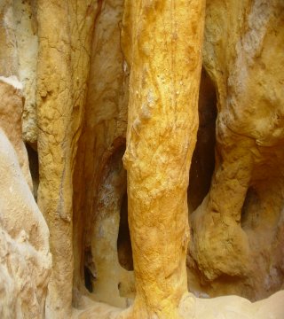
Brauneisenablagerungen und Konglomerat eines Meeresküstenstrandes
aus dem geologischen Erdzeitalter des Tertiär. An einem Berghang
unterhalb der Burgruine Battenberg gelegen, entlang der
Kreisstrasse.
Eine meterhohe Sandstein-Felswand steht dort unter Naturschutz,
weil sie rund 32 Millionen Jahre alte Meeressande aus dem
Erdzeitalter Tertiär beinhaltet! Ihre ockerfarbenen Sandsteine sind
von röhrenförmigen Brauneisenanreicherungen durchzogen, das Innere
mit rotem bis braunem Sand verfüllt. Die Röhrenbildungen entstanden
dabei durch reine Ausfällungen und Sinterbildung kieselsaurer
Eisenlösungen. In Wasser (wässriger Lösung) mitgeführtes Eisen
wurde schalig (konzentrisch) ausgeschieden und verwandelte im
Bereich der Ablagerung den losen Sand in einen festen Sandstein,
der dort an manchen Stellen bis zu 30 Prozent Brauneisen enthalten
kann.
Um den Cache als Fund zu loggen sendet bitte eine eMail an mich mit
der Antwort auf folgende Fragen:
1.) Welche Jahreszahl steht auf der eingebetteten Steintafel?
2.) Wie hoch schätzt Ihr ist die Röhrenwand an dieser Stelle?
3.) Über wieviel Meter Länge sind die Röhren freigelegt
(eingezäunter Bereich)?
Optional: Wenn möglich hängt bitte eine Foto an das Log welches
Euch mit dem GPS in der Hand vor den Blitzröhren zeigt.
Nachdem Ihr Eure Antworten geschickt habt
könnt Ihr Euren Besuch sofort online loggen (wartet nicht auf meine
Bestätigung). Sollten Eure Antworten nicht korrekt sein dann melde
ich mich schon, Logs ohne Mail mit den Lösungen muss ich leider
wieder löschen.
ACHTUNG: Achtet gut auf den Verkehr, die Röhrenwand befindet
sich direkt neben der Strasse, Ortseingang Battenberg entlang einer
Kurve!
|
 English:
|
|
Iron sedimentary site and conglomeration from the seashore of the
geological era of tertiary. Along the mountainside underneath the
castle ruins of Battenberg next to the road. A unique geological
phenomenon for Rhineland-Palatinate and for whole Germany are the
so called “Blitzröhren” of Battenberg (near Grünstadt).
They are located on the southern mountainside below the castle
ruins of Battenberg.
These sandstone rock formation are declared as a nature protection
area. The rocks contain seaside sands from the geological era 32
million years ago the age of tertiar! The ochre colored rocks are
sieved by pipes of iron callositys the inner is filled up with red
and brown sands. The process of pipe forming was forced by pure
precipitation and sinter formation of silicic acid iron solutions.
The iron carried with the water (aqueous solutions) was separated
concentrically and turned the loose sands into solid sandstones
with a contingent of iron up to 30 percent.
To log your find please answer me the following (by email):
1.) Which date is shown on the imbedded stone plate?
2.) How high do you guess the wall is at this point?
3.) How many meters long are the Röhren (fenced areal)?
If possible please attach a picture of you, you’re GPS taken
with the “Blitzröhren” in the background to proof you
visited the site.
You can log immediately your visit online
after having sent the answers. It is not necessary to wait for my
confirmation as I'll contact you in case there are errors in your
answers. Should you log without sending me an answer I'll have to
delete your log.
NOTE: Be aware of the traffic while shooting the pics, it's
right at the entrance of Battenberg along the road!
|

Additional Hints
(No hints available.)