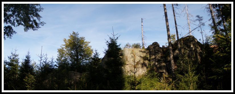
FROST CLIFF - Hunter´s Stone

Irregular nubbin hight 1100m and 4,0 km south from Borova Lada, which rank to massif Polecky vrch, that includes several thousand summits (SW and VV) and is delimited of Vltavsky brook on west, Tepla Vltava on north-east , from south after Polecky brook. Rock is at fur-lining in gneiss with stones and rock waste . Forestation of spruces with rowans and beechs , which sometimes dominate.
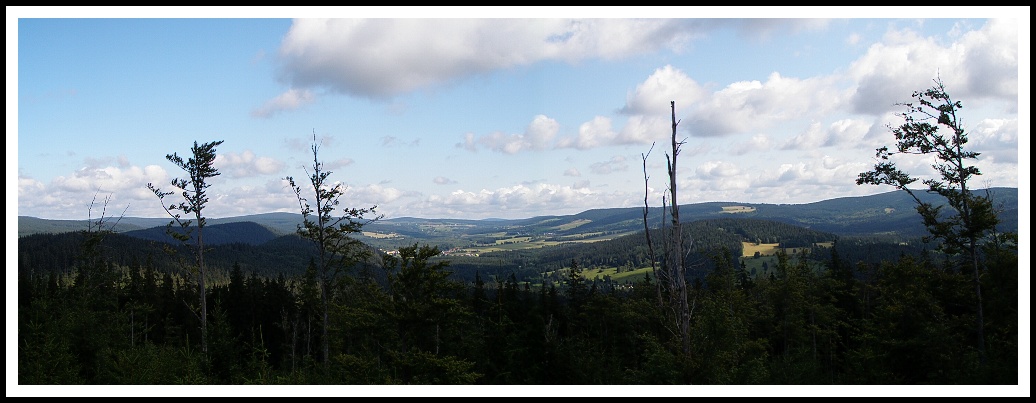
View from Hunter Rock to valley Borova Lada / Pohled z Lovciho kamene do udoli Borove Lady
Frost cliff - cryoplanation terraces
- stair-step shapes on slopes which are rising because of cryogenic processes
- They consist flatware, platform and stair
- stair may have form of rock wall (frost cliff), slant 80 – 90° or form of steep slope covered with sharp-edged fragments of rock mineral (frost drop-off), slant 15 – 30°
- slant of flatware 1 – 12°
Cryogenic forms
- shapes caused by influence of frost weathering
- on the principe of phase transformation of water in rocks's cracks ( freezing increases in volume by up to 9% )
- it leads to freeze fragmentation (kongelifrakcion, gelivacion)
- it's intense in well bedded, cracked or porous rocks
- stones sea, stones currend , cryoplanation plattforms and flatwares, frost cliffs, rock barriers, polygonal earth, thufury…
Characterization
- rocks's degree incurred by frost weathering and denuding
- slant 80 - 90° , sometimes walls are overhanging
- hight and width are different (a few metres to tens of metres )
- largest cryoplanation plattforms with massive frost cliff are on Ural and Siberia (several kilometres)
Presence
- in all of area pleistocen and present periglacial zone
- they are relating to resistant rocks (especially gneisses, qoartz rocks, sandstones, cawks and etc.), in whichin can maintain
Enlargement
- currently in northern pert of Europe, Asia, America, in Antarctica, sounthern part of South America and in high mountain areas around the world
- in the Czech republic: CHKO Šumava, NP Krkonoše, CHKO Ždárské vrchy, CHKO Jeseníky
Orography and geology Sumava mountain.
The Sumava is one of the oldest mountains in the Europe.It is created by rocks, especially archeozoic and paleozoic ones (granites, gneisses, schists). Big part of bohemian forest´s area occupies the central moldanubic massif. Bohemian forest was caused by alpine folding in Tertiary by elevation and fracture of old massif´s planed peneplain. It is cca 140 kilometers long woody mountains with rounded terrain´s forms with large plateau ( Plains in the area of Kvilda, Vydra and Kremelné – cca 1 000 – 1 100 meters above sea). From Plains project mountain-ridge drift towards north-west and south-east. In the central part there are more expressive salient tops and deeper erosioned valley of water flow. To the most important tops of bohemian forest belong Plechý (the biggest mountain of the bohemian forest´s czech side – 1 378 m), Trístolicník, Smrcina (1 337 m), Knížecí Stolec (1 225 m), Boubín (1 361 m) and Špicák (1 221 m). Relics of glacier activity, for example rock shapes, frost cliff, stone seas and glacier lakes, are very attractive.
 |
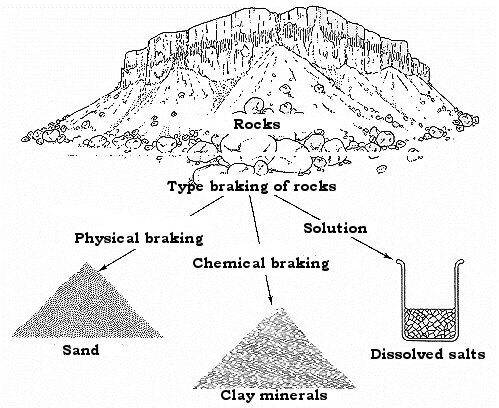
Processes of weathering / Schematicky proces zvetravani
|
WEATHER PROCESSES In order to allow external geomorphological processes acting on the surface, rocks have to be weathered. However, weathering isn‘t geomorphological process. Geomorphological processes causing erosion, mass transport and accumulation (sedimentation). During the weather process happen disintegration or decomposition of rocks but geest abide at a place. Rocks any origin were set in different depth of earth crust where were affected by stable pressure and temperature. As soon as rocks get to surface from depth, weather processes start to acting which create irreversible changes – geest are rising (eluvium). As soon as rocks are getting to the surface, they are affected by lesser pressure of superposed bed and rocks tend to expansion. On the score of that there are rising cracks. Towards surface temperature start to variously sway.
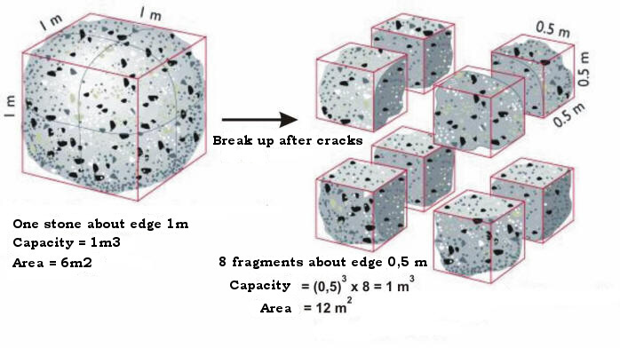
Example frost weathering / Priklady mrazoveho zvetravani
You must fulfill the requirements for log this cache:
1) What are the factors of intensity weathering and under what conditions is most intensive ?
2) What power effects ice on walls's cracks and cavites ( in MPa ) ?
3) What kinds of weathering there are?
4) Insert your photo with GPS picture to log from leads coordinates with spoiler
5) Altitude at the position.
6) All answers send to my email krutizlab.geo@gmail.com
The answers which will not comply with the requirements will be deleted. |

Nepravidelny suk 4,0 km jizne od Borove Lady, ktery nalezi do masivu Poleckeho vrchu, jenz cita nekolik tisicimetrovych vrcholu (JZ a Z) a je ohranicen Vltavskym potokem na zapade, Teplou Vltavou na severovychode, z jihu pak Poleckym potokem. Jedna se o vlozku porfyru v rulach se skalkami a suti. Zalesnen smrcinou s primesi jerabu, javoru a zejmena buku, ktery misty prevlada.
Mrazovy srub - kryoplanacni procesy
- terasovite tvary na svazich, ktere vznikaji kryogennimi pochody
- skladaji se z plosiny terasy a stupne
- stupen muze mit tvar skalni steny (mrazovy srub), sklon 80 – 90° prikreho svahu pokryteho ostrohrannymi ulomky skalnich hornin (mrazovy sraz), sklon 15 – 30°
- sklon plosiny 1 – 12°
Kryogenni tvary
- tvary zpusobene vlivem mrazoveho zvetravani
- na principu skupenske premeny vody v puklinach hornin (pri mrznuti zvetsuje objem až o 9%)
- dochazi k mrazovemu tristeni (kongelifrakce, gelivace)
- intenzivni v dobre zvrstvenych, rozpukanych ci porovitych horninach
- balvanove more, balvanovy proud, kryoplanacni terasy a plosiny, mrazovy srub, skalni hradba, polygonalni pudy, thufury…
Charakteristika
- skalni stupen vznikly mrazovym zvetravanim a odnosem
- sklon 80 - 90° , nekdy jsou steny az previsle
- vyska i sirka ruzna (nekolik metru az desitek metru)
- nejrozsahlejsi kryoplanacni terasy s mohutnymi mrazovymi sruby zjisteny na Urale a Sibiri (nekolik kilometru)
Vyskyt
- v cele oblasti pleistocenní a soucasne periglacialní zony
- vazany na odolne horniny (zejmena ruly, kremence, piskovce, vapence a dalsi), v kterych se muze udrzet
Rozsireni
- v soucasne dobe v severni casti Evropy, Asie, Ameriky, v Antarktide, jizni casti Jizni Ameriky a ve vysokohorskych oblastech celeho sveta
- na uzemi CR: CHKO Sumava, NP Krkonose, CHKO Zdarske vrchy, CHKO Jeseníky
HOROPIS A GEOLOGIE ŠUMAVY
Sumava, jako jedno z nejstarsich pohori Evropy, je tvorena horninami zejmena prahorniho a prvohorniho stari, zulami (Prášily, Trístolicník, Knížecí stolec), rulami (Boubín) a svory (Ostrý). Velkou cast sumavskeho uzemi zabira centralni moldanubicky masiv. Sumava vznikla pri alpinskem vrasneni v tretihorach vyzdvizenim a rozlamanim zarovnane paroviny stareho masivu. Je lesnatym cca 140 kilometru dlouhym pohorim (k nemuz patri i rozsahle predhuri) se zaoblenymi terennimi formami s rozsahlymi nahornimi plosinami (Pláne v oblasti Kvildy a v oblasti Vydry a Kremelné - cca 1 000 - 1 100 metru nad morem). Z Plani vybihaji severozapadnim a jihovychodim smerem horske hrbety. V centralni casti se nachazeji vyrazneji vystupujici vrcholy a hloubeji vyerodovana udoli vodnich toku. K nejvyznamnejsim vrcholum pohori patri Plechy (nejvyssi hora ceske strany Sumavy - 1 378 metru nad morem), Trístolicník, Smrcina (1 337 metru), Knížecí Stolec (1 225 metru), Boubín (1 361 metru) ci Špicák (1 221 metru). Atraktivni jsou pozustatky cinnosti ledovcu v podobe skalnich utvaru, kamennych mori, ledovcovych jezer, ktere jsou jedinymi ukazy tohoto typu v Ceske republice
ZVETRAVACI POCHODY Aby mohly vnejsi geomorfologicke procesy pusobit na povrch, musi byt horniny zvetrany. Avsak zvetravani neni geomorfologickym procesem. Geomorfologicke procesy zpusobuji erozi, transport hmot a ukladani (sedimentaci). Pri procesu zvetravani dochazi k rozpadu nebo rozkladu hornin, ale zvetralina zustava na muste. Horniny jakehokoli puvodu vznikly v ruzné hloubce zemske kury, kde na ne pusobily stabilni tlak a teplota. Jakmile se horniny z hloubky dostavaji k povrchu, zacinaji na ne pusobit zvetravaci procesy, ktere na nich vytvari nevratne zmeny - vznikaji zvetraliny (eluvia). Jakmile se hornina dostava na povrch, pusobi na ni mensi tlak nadloznich vrstev a hornina ma tendenci se rozpinat, diky cemuz v ni vznikaji trhliny. Smerem k povrchu zacina teplota navic ruzne kolisat.
Pro uznani teto kese zodpovezte prosim na par nasledujicich otazek:
1) Jake jsou faktory intenzity mrazoveho zvetravani a za jakych podminek je toto zvetravani nejintenzivnejsi ?
2) Jakou silou pusobi kapilarni led na steny trhlin a dutin ( v MPa ) ?
3) Jake typy zvetravani rozlisujeme?
4) Vlozte Vase foto s GPS pristrojem na miste dle spoiler
5) Jaka je nadmorska vyska na pozici ?
6) Vsechny odpovedi zasilejte na email krutizlab.geo@gmail.com
Odpovedi, ktere nebudou obsahovat pozadovane informace, budou dle pravidel smazany !