R48 Ostravice Traditional Geocache
RadimKo: Dlouho jsem váhal mezi obnovou a archivací této keše. Zvítezila varianta druhá. Tímto dekuji za pekné logy.
-
Difficulty:
-

-
Terrain:
-
Size:  (small)
Please note Use of geocaching.com services is subject to the terms and conditions
in our disclaimer.
[CZ] Další z plánované série mapující trasu obchvatu Frýdku-Místku.
Lehká, rychle dostupná keš, vhodná pro cyklisty.
[ENG] Planned series of the Frydek-Mistek by-pass highway next
cache: It is easy, quickly accessible, suitable namely for
bikers.
R48 Ostravice
[CZ] Významným beskydským šterkonosným tokem je pravostranný prítok
Odry, reka Ostravice se svou celkovou délkou toku 63,5 km a
rozlohou povodí 826,79 km2. Prestože je Ostravice témer v celém
úseku regulována, ve vymezeném prostoru koryta stále dochází
neustálým preskupováním a akumulacím nových sedimentu (relativne
prirozené skladby) k tvorbe typických dnových struktur – šterkových
lavic. V zemích Evropské unie se jedná o vzácná stanovište, proto
byl úsek Ostravice mezi Paskovem a ÚN Šance navržen do soustavy
Natura 2000 jako evropsky významná lokalita (EVL) pro vranku
obecnou (Cottus gobio). Z chránených druhu jsou od Ostravy až po
úsek nad ÚN Šance dále zaznamenány kriticky ohrožený rak rícní
(Astacus astacus) a na vhodných, proudove klidných místech, zejména
mezi Frýdkem-Místkem a Frýdlantem nad Ostravicí, kde se ukládá
jemný sediment, rovnež kriticky ohrožená mihule potocní (Lampetra
planerii). Vzhledem k neobvyklému rozsahu výskytu biotopu
sterilních šterkových náplavu je aktuálne navržen jako lokalita
vhodná k doplnení do národního seznamu EVL. Jejich výskyt je s
výjimkou toku Morávka, Olše a Ostravice na území CR mizivý. Mezi
evropsky významné biotopy patrí rovnež brehové porosty s
dominantním zastoupením vrb (svaz Salicion eleagno-daphnoi dis).
[ENG] The remarkable gravel river is the right-side tributary of
the Odra, the river Ostravice with its total length 63,5 km and
acreage of basin 826,79 km2. In spite of the fact that the
Ostravice is almost in the hole tract regulated, in the restricted
range of river-basin by permanent reordering and storage of new
sediments (relatively of natural structure) still happens making
typical ground structure – the gravel benches (?). These are rare
sites in the countries of EU and that is why the range of the river
Ostravice between Paskov and damming Šance was nominated to system
Natura 2000 as an European prominent locality (EVL) for vranka
obecná (Cottus gobio). From among endangered species are from
Ostrava to section above dumming Šance noticed critically
endangered rak rícní (Astacus astacus) and in appropriate, still
flows, especially between Frýdek-Místek and Frýdlant nad Ostravicí,
where mild sediment stores, critically endangered too mihule
potocní (Lampetra planerii). According to unusual range of
appearance of biotope of sterile gravel sediments is nowadays
nominated as an locality suitable for enlistment to national list
EVL. Their appearance with an exception of the river Morávka, the
Olše and the Ostravice is on territory of CR dissapearing. To
European prominent biotopes belongs also bank stands with dominant
represantation of willowtrees (association Salicion eleagno-daphnoi
dis).
 [CZ] Tady nekde bude most
[ENG] Somewhere here will be the bridge
[CZ] Silnice R48 je soucástí mezinárodní silnice E462 Brno - Ceský
Tešín - Krakov. V míste uložení této keše bude(?) mezinárodní tah
križovat stávající cyklostezku a reku Ostravici. Doporucuji proto
tuto lokalitu navštívit dríve, než se její charakter zcela zmení
plánovaným premostením. A kdo má rád vodu, tak mu doporucuji i
splavení Ostravice pri vhodném stavu vody.
[ENG] Road R48 is a part of international road E462 Brno - Ceský
Tešín - Krakov. The international road will cross the current
cyclo-trail and the river Ostravice in the place where the cache is
located. According to this, I recommend you to visit this area
before its character is changed by planned bridging. To those who
like water I recommend navigating the river Ostravice when the
condition of water is right.
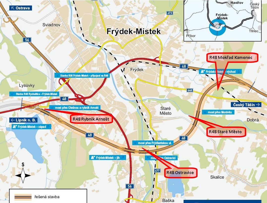 [CZ] Mapka trasy obchvatu a kešky R48
[ENG] Map of the by-pass highway path and of R48
caches
Zverejneno u príležitosti 2. Frýdecko-Místeckého
geopokecu
Additional Hints
(Decrypt)
xhf fzexh/n cvrpr bs fcehpr