Algonquin at the Sea EarthCache
-
Difficulty:
-

-
Terrain:
-

Size:  (not chosen)
Please note Use of geocaching.com services is subject to the terms and conditions
in our disclaimer.
Highlands of Algonquin Park. The coordinates take you to the
Visitor Center of Algonquin Provincial Park.
1. A special place
Established in 1893 Algonquin was the first provincial park in
Canada and the forerunner of Ontario’s extensive park system. Its
unique landscape that was formed during millions of years of a
colorful geological history has long attracted both artists and
environmentalists. Algonquin Park is surrounded by lower areas like
Lake Nipissing or the Ottawa Valley.
So how come Algonquin became an Upland with an elevation of up to
520m?
Why is there such an abundance of lakes?
Why are there so many cliffs putting their special mark to this
landscape?
To find the answers and to understand the basic of this precious
ecosystem we need to embark on a journey through ancient times, ice
ages and through times of merging continents.
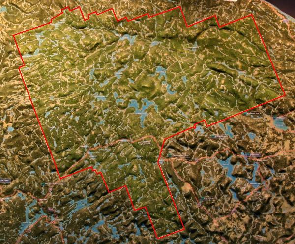
Pic 1: Topographic model of Algonquin in the Visitor Center
2. Drifted away
Understanding the drift of continents in ancient times was a major
break through in the geological science. Our earth consists of
different layers created by gravity meaning that the lighter
materials are floating on the outer layers of our planet. The two
top layers of the earth are the asthenosphere and the lithosphere.
The asthenosphere consists of molten rock. The lighter lithosphere
with its uppermost part the continental or oceanic crust floats on
top of the asthenosphere. The crust itself is broken into curved
plates that are slowly moving on the earth’s surface like huge
ships on an ocean. The plates will eventually crush, one plate
might be subducted and be forced into the earth or the plates can
collide and pile up to form mighty mountain ranges. All these
phenomena have occurred in Algonquin. 1200 million years ago the
ancient continent of Nena formed the core of what today is North
America. Colliding with the continent Atlantica Nena was pushed
down and large parts of the crust were piled up to a high mountain
range (the Grenville Mountains).
Amazing that the land we stand on today in Algonquin was still
buried 25-30 kilometers deep under the highest peaks of Grenville
mountains. Atlantica and Nena continued to press against each other
with enormous force and finally merged to form the new super
continent Rodinia (980 million years ago). The next 400 million
years things remained relatively quite and controlled. The mountain
slowly eroded – a mere millimeter every 10 years! But during 400
million years even the highest mountains were worn down by wind and
water, ice and snow.
With the progressing erosion the weight of the high mountains
slowly receded and the rocks of Algonquin ultimately rose to the
earth’s surface for the first time. At the same time underneath
Rodinia other forces piled up: The heat of the earth’s core that
was trapped under the huge shield of Rodinia finally broke through
the crust and Rodinia was split into the two new continents.
Finally Algonquin settled underneath the sea level and was flooded
by the waters of Iapetus. Sediments settled on top of Algonquin and
were transformed into sedimentary rocks that accumulated hundreds
of meters thick.
3. Meteooooor!!!
It all happened here. 450 million years ago a gigantic meteor of
150m diameter smashed into Algonquin at 72.000 km/h. The force of
the impact created the 4km wide and 600m deep Brent crater that is
easily accessible from the north side of the park.
Continuous continental drift and a succession of collisions finally
lifted Algonquin back up above the sea level – just in time for the
arrival of the Dinosaurs 250 million years ago. However all
evidence of them and all the sedimentary rocks eroded away over
time – once again helping the Grenville Rocks to rise and form the
highlands of Algonquin.
4. Get your mittens ready
While the general shape of the land was generated over 1500 million
years by drifting continents, building mountains and erosion
another event had as much of an impact on Alqonquin – the ice
ages.
Ice ages describe a situation when the poles are ice covered and
the ice might even extend half way to the equator. In earth history
the poles have been usually free of ice – helped by the sun, the
warm currents of the oceans and the global wind conditions.
Sometimes however moving continents might interrupt the currents of
the ocean. In those situations the snow that accumulated over the
winter months won’t melt away in summer and more and more snow will
build up. Pressure will turn the snow into ice and glaciers form.
The snow and the ice reflect the sunbeams even more and will
therefore accelerate the cooling process on earth.
A total of 4 ice ages occurred in earth history and just recently
(approx 115.000 years ago until 11.000 years ago) Algonquin was
covered under an up to 3 kilometer thick layer of ice. The ice,
snow and the glaciers completely disrupted the drainage of water in
the Algonquin Highlands. Had Algonquin formerly drained through
rivers into the ocean the ice and snow blocked the water from
flowing downhill. In addition the gravity made glaciers move
downhill bulldozing the landscape underneath, pushing the soil away
and enabling water to accumulate into the depressions in the
bedrocks. This is one of the main explanations for the high number
of lakes in Algonquin.
5. Algonquin at the Sea
When the glaciers started to melt they left silt, clay, sand,
pebbles and rocks (the glacial tilt). Whenever the melting water of
the glacier was drained in streams the heavy components of the
glacial tilt sunk right to the floor while the lighter material got
carried away with the river. These glacial outwash deposits are
always sorted – with the heaviest material being closest to the
glacier and lighter material being distributed over many kilometers
along the bottom of the river. One of the large meltwater channels
crossed the park starting at the Kiosk area all the way to Petewawa
basin. Thousands of tons of sand settled along the steady flow of
water and formed the sandy habitat of the Eastern Lowlands of
Algonquin.
11.800 years ago the ice in Algonquin finally retreated and Lake
Algonquin and Lake Iroquois were created to the south of the
current park area.
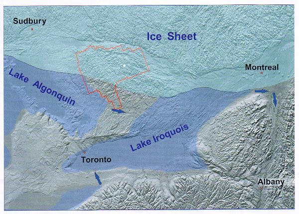
Pic 2: Ancient Lakes
In the north the thick cover of the ice was still lingering with
its weight pushing the Ottawa and St. Lawrence river valley under
the sea level. With the ongoing melting of the ice Atlantic water
eventually flooded these valleys and created the Champlain Sea.
Alqonquin was linked to the Atlantic. Imagine – Algonquin with an
ocean beach. Back then it was reality!
However this effect didn’t last long. With the ice retreating north
the river valleys finally rose and the Champlain Sea disappeared.
Amazingly enough even today the land is still rising 2mm every year
and gradually recovering from the burden of the ice.
6. The Algonquin habitat of today
With the glaciers gone and only unfertile glacial tilt covering the
bedrocks erosion set in again. Wind, rain, sun, frost, lichens and
mosses started their work to turn rocks into valuable soil.
A lengthy process. To build one inch of soil it takes up to 100
years of erosion. So please remember to stay on marked trails when
you visit sensitive areas. Any damage of the spare vegetation will
impact the generation of soil that is required to maintain
Algonquin’s Ecosystem.
Now please step out to the viewing platform and watch the erosion
proceeding. The tilted hills at the horizon were created by the
weaker layers of the hills eroding faster while the more resistant
forming ridges and cliffs.
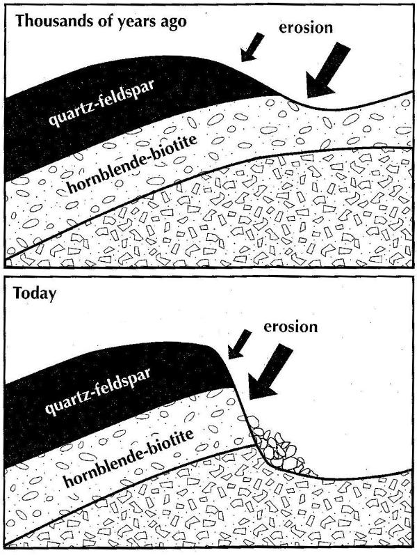
Pic 3: Erosion generated Algonquin’s cliffs
In order for you to log this cache please send me an email with the
following information and post the require pictures:
a. What is the name of the Sea that connected Algonquin to the
Atlantic?
b. At the coordinates of the cache there are 2 ancient witnesses of
Algonquin history located. Estimate their heigth and determine how
many years it will take until they are completely eroded.
c. Post your log together with a pic of you and your GPS on the
viewing platform
d. Post a pic of your favorite Algonquin spot, animal or plant.
For more information on the geology of Algonquin please refer to:
a. Ahern, Frank: Algonquin Park, Through Time and Space, 2006.
b. Strickland, Dan: Lookout Trail
Additional Hints
(Decrypt)
o. Purpx gur pnpur qrfpevcgvba gb trg gur vasbezngvba lbh arrq gb qb gur pnyphyngvba.