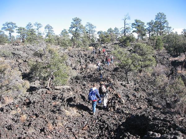
To reach the “…longest lava tube system in the continental United States” you’ll make a level hike of 2 to 2½ miles round-trip over rough and jagged lava rock (see Coconino Buckeye’s EarthCache on the types of lava rock).
This may be a bit more difficult than others, but not too bad with good weather and adequate preparation (boots, sun protection, and plenty of drinking water). We really enjoyed our visit, but it was November. Please take seasonal-appropriate cautions, and please do not attempt this one alone. Additionally, thunderstorms can be especially hazardous as you may be the highest point in an area and taking shelter under trees is no safer.
El Malpais National Monument and the adjoining El Malpais National Conservation Area were established in 1987 to manage the Zuni-Bandera volcanic field and surrounding land. The Zuni-Bandera field lies within a volcanic region that extends from south-central Arizona to northeastern New Mexico. Nearby Mt. Taylor “represents the oldest local activity, 1.5 to 4 million years old." The lava flows in the Malpais “originate from eight major vents in the park and in the adjacent Zuni Mountains.” A very nice exhibit on the history of the flows used to be at the now closed Information Center on Highway 53. We recommend a visit to the newer Visitor Center off Interstate 40, Exit 85.

Geochronology
“The chronology of lava flows in the Zuni-Bandera volcanic field has been difficult to determine due to the composition of the lava flows. A summary of flow ages is given below.
“Summary of lava flows in the El Malpais area (from Mayberry et al., 1999; Laughlin et al., 1993; Laughlin et al., 1994; Dunbar and Phillips, 1994; Phillips et al., 1997).
| NAME |
VENT |
TYPE OF FLOW |
AGE |
| McCartys |
McCartys shield |
Pahoehoe sheet flows, aa |
2,500-3,900 |
| Bandera |
Bandera Crater |
Aa and tube fed pahoehoe |
9,500-10,900 |
| Cerro Hoya |
Cerro Hoya shield |
Pahoehoe sheet flows |
|
| Lava Crater |
Lava Crater shield |
tube fed pahoehoe |
16,000 |
| Lost Woman Crater |
Lost Woman cinder cone |
Channelized and tube fed pahoehoe |
|
| Twin Craters |
Twin Craters cinder cone |
Channelized aa and tube fed pahoehoe |
15,800-17,800 |
| Laguna |
El Calderon |
|
33,400 |
| Bluewater flow |
El Tintero cinder cone |
|
35,600-79,000 |
| Candelaria |
Cerro Candelaria |
aa |
|
| El Calderon |
El Calderon cinder cone and shield |
Aa flowed by pahoehoe |
115,000 |
The Big Tubes area of El Malpais are part of the Bandera flow. As shown, the Bandera flow originated about 10,000 years ago. Although second in youth to the McCarty’s eruption (2,500 – 3,900 years ago), both were very recent events geologically. Anthropological dating, from the histories of the indigenous peoples, estimate activity as recent as 1,000 years ago and is reflected in some sources.
“Lava tubes are a very interesting feature of basaltic lava flows. As basaltic lava cools, the outer part can solidify to form a shell around the inner, still molten and flowing part. The cool crust acts as a very effective insulator for the inner, hotter lava, allowing it to flow for very great distances, and greatly extends the distances over which basaltic lava flows can travel. Single lava tubes up to 10 km in length have been recognized in Hawaii (Francis, 1993). Lava tubes have been recognized in many parts of the world, and also may have been recognized on giant Martian volcanoes (Francis, 1993).” (http://geoinfo.nmt.edu/tour/federal/monuments/el_malpais/zuni-bandera/lava_tube.html
This site (http://www.explorenm.com/hikes/BigTubes/) lays out the drive and hike very well. In short, county road 42 turns south from State Highway 53 about 27½ miles from I-40 near Grants. The Big Tubes turn off is 4.1 miles down 42, and the parking area 2.7 miles to the east. These roads can be impassible after heavy rain or in winter. Bandera Crater is on private land (near the commercial Ice Cave), but can be clearly seen from CR 42.
To log this EarthCache:
1. Follow the cairn-marked trails to at least two of these features: Big Skylight Cave, Caterpillar Collapse, Four Window Cave, Seven Bridges. Big Skylight Cave is the first feature and near the trailheads for the others. In your log, post a photo of yourself and/or your GPSr with one of the wooden signs As of 1 January 2011, photographs are optional, but we'd still like to see what you saw!
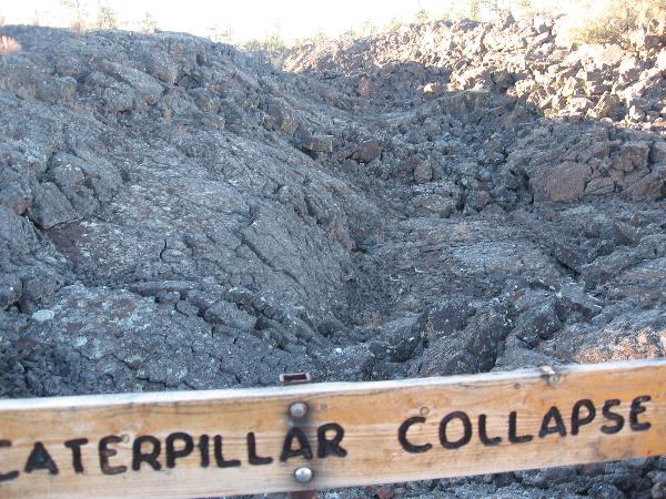
2. Determine the width of a least two of the listed features. Your GPSr will probably be most accurate, but you may use another method. Send us a message with your width measurements, the method used to obtain them, and your ideas about the differences in width with regards to the differences in the features (cave, collapse, bridge).

The Park Service again allows entering some caves here, but only with a cave permit number that must be obtained in person at either the visitor center in Grants (exit 85) or the El Morro visitor center west on Highway 53. White-nose Syndrome is still a threat to hibernating bats and precautions must be taken as directed by the Park Service to keep it from spreading to New Mexico. This EarthCache does not and has never required entry into Big Skylight Cave (not really an underground cave) or Four Window Cave (about 600’ long), and you should not attempt entry without adequate preparation and even first consulting with the rangers at the visitors’ center when you obtain your permit. We did traverse Four Window Cave, but had helmets, lights, extra lights, good boots, and several responsible adults. One point deep inside requires climbing slippery rocks to another level about 6’ to 8’ higher (if coming from the south). Stone ledges on the cave walls showed where the molten lava once flowed.
More good hike coords and info: http://www.trimbleoutdoors.com/viewTrip.aspx?tripId=372408
Terracache Virtual of this location: http://play.terracaching.com/Cache/TC7JZ (site now requires log on)