Tato keš byla dne 8. března 2017 adoptována od původního ownera Nerd Angel. Listing je ponechán v původní podobě.
CZ: ALEJ SMIRENI
Alej smireni byla zalozena v miste byvale osady Taflova Hut asi 5 km jizne od Vimperka v drive osidlenem uzemi v CHKO Sumava. Nekdejsi pritomnost lidi pripominaji v soucasne dobe tri pamatne stromy - dve lipy a jeden dub.
Alej ma dve casti. Prvni je tvorena kombinaci ceskeho narodniho stromu - lipy a nemeckeho narodniho stromu - dubu. Celkem zde bylo vysazeno 34 stromu. Tato cast aleje je zakoncena primo v prostoru, kde stavala osada Taflova Hut.
Druhou cast aleje tvori ovocne stromy. Informacni panely na odpocivnem miste, ktere bylo zrizeno v prostoru byvale Taflovy Huti, jsou zamereny na seznameni s drivejsim souzitim obou narodu v pohranicni oblasti Sumavy.
.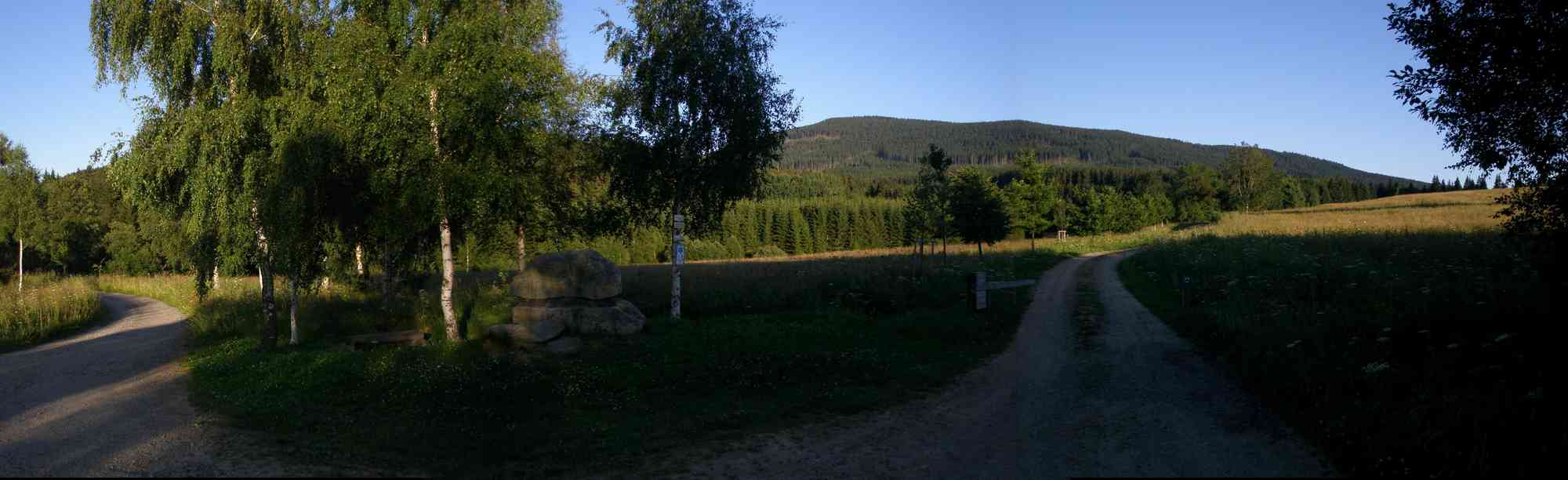
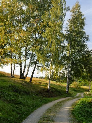
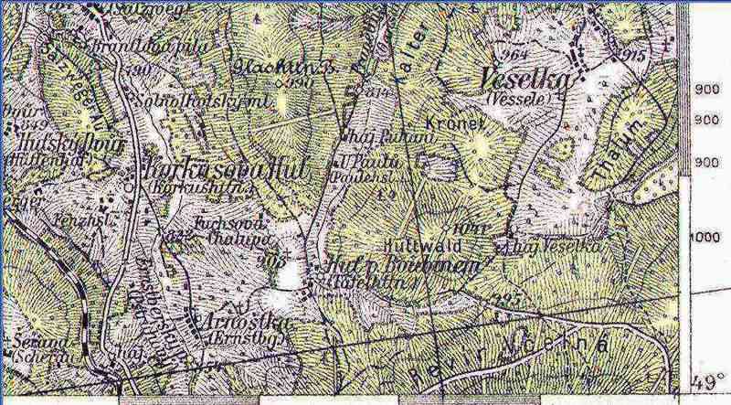
Vlastni alej neni prilis dlouha. Jeji vyznam je spise symbolicky - spolecne rostouci lipy a duby maji pripominat bezproblemove souziti Cechu a Nemcu v dobach pred druhou svetovou valkou. Pristup k aleji je mozny z Vimperka od autobusoveho nadrazi po turisticke znacce smerem na Hajnou Horu. V miste odbocky znacky vpravo se pokracuje vlevo udolim Pravetinskeho potoka. Moznost pristupu je i z Pravetina po lesni ceste podel toku Pravetinskeho potoka. K aleji je mozny pristup i od Korkusovy Huti po lesni ceste (asi 2 km).
Zajimavosti na trase:
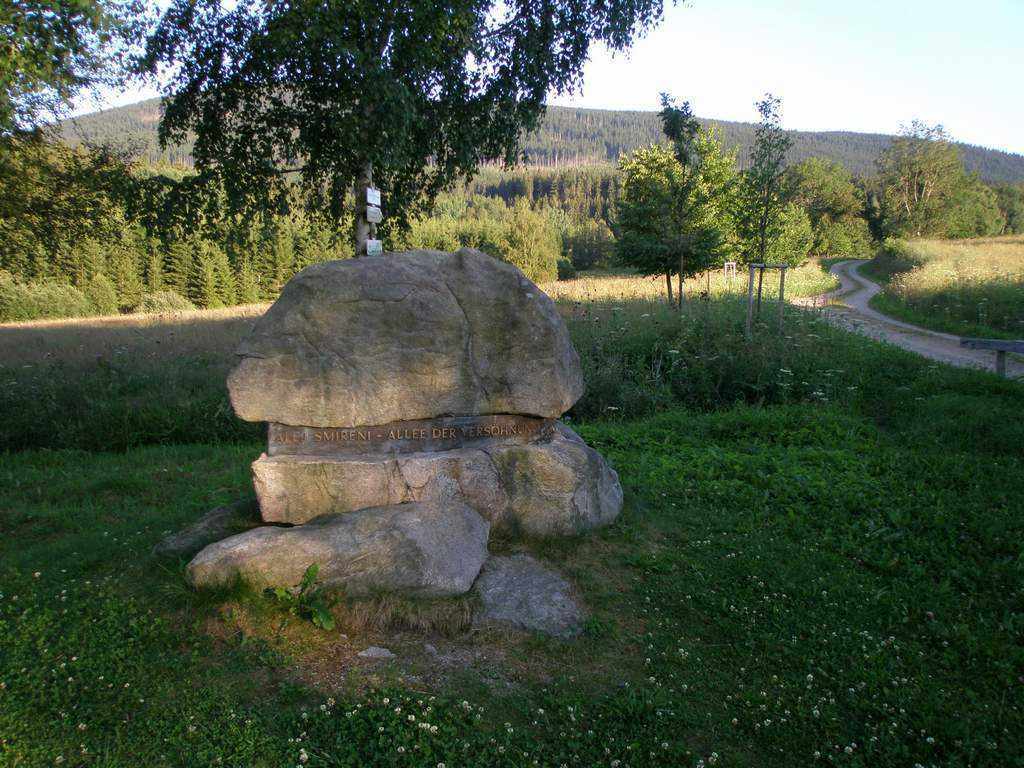
V miste byvale osady Taflova Hut je odpocinkove misto s osazenymi informacnimi tabulemi, ktere navstevnikum priblizuji symboliku Aleje smireni i historii souziti Cechu a Nemcu v predvalecnem obdobi.

CZ: TAFLOVA HUT
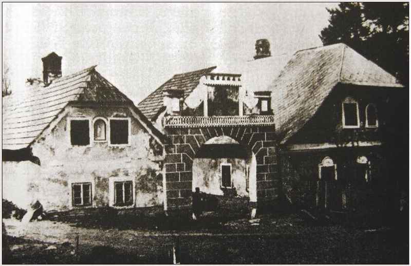
Samota zvana Taflova Hut (Tafelhütten) pod severnim svahem hory Boubin (Kubani) je poprve zminovana roku 1619 (ceske oznaceni Hut pod Boubinem). Prvym osadnikem byl pry Wölfl Plechinger a jeho dum byl pozdeji prebudovan na sklarskou hut. Usedlost predal Plechinger svemu synu Krystofovi, podle jehoz zdrobneleho krestniho jmena (Christoph se v nemcine zdrobnovalo i na Töffel) se odtud hut nazyvala, ponevadz pak vedle levneho duteho skla se tu vyrabely i sklenene perly do ruzencu zvane narecne "Beteln", mame tu i vysvetleni mistniho jmena Tofel-Bettlhütten. Aby byl usetren les, byla roku 1722 hut zrusena. Tehdejsi hutmistr Lampert Plechinger provozoval nadale uz jen zemedelske hospodarstvi, ktere pak preslo do vlastnictvi rodiny Korbischovy, jiz nalezelo od te doby bez preruseni. Korbischovi navic pri krtu davali chlapcum vyhradne jmeno Johann. Tak Johann Korbisch a jeho manzelka Maria predali dvorec synu Johannovi, ktery se narodil 14. unora 1802, a byl to opet Johann, narozeny 1850 a po nem jeste jeden, rocnik 1877, jimz pozdeji pripadl. Pak prisel osudovy zvrat, kdyz dalsi z Korbischovych Johannu, tento s datem narozeni 13. brezna 1925, zmizel roku 1944 beze stopy kdesi na ruskem bojisti za druhe svetove valky jako vojak nemeckeho wehrmachtu. Na statku hospodarila za neho sestra Marianne, provdana Graupeova, nez nadesla dalsi osudova rana v podobe nasilneho vysidleni. Korbisch-Hof osirel. Jako pripadny dedic prichazel v uvahu tenkrat jedine, treba poznamenat, Mariannin syn a doktor prav (Dr.jur.) Johannes Graupe (tedy opet Johann!). Korbisch-Hof s 56 hektary poli, luk i lesa musel byt tehdy pocitan k nejvetsim selskym usedlostem tady v okoli. Konecna hodina zkazy uderila tomuto kdysi znamenitemu statku v roce 1963, kdy cesky tank staveni nejprve rozstrilel a pak srovnal se zemi. Tak provzdy zanikla nekdejsi hut pod Boubinem, zvana Taflova (nekdy se podle mylneho vykladu toho privlastku pise cesky i Taflova, tj. "tabulova" Hut). Tam, kde kdysi kvetlo lidske dilo, zbyla jen mohutna lipa jako osamely monument, pripominajici zivot zasle sumavske samoty.
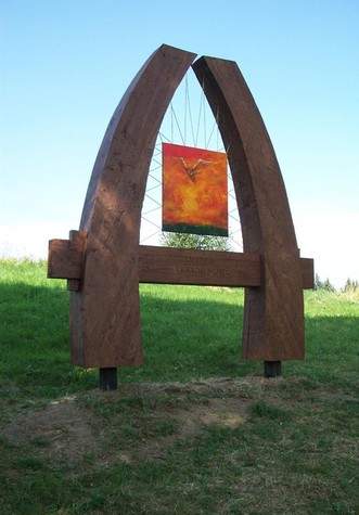
V cervnu 2002 zde zalozena Alej smireni. Studenti gymnazii z bavorskeho Waldkirchenu a Freyungu a skol ve Vimperku vysadili na miste byvale osady alej, ktera ma dve casti. Prvni tvori 17 lip a 17 dubu - ceske a nemecke narodni stromy, ve druhe casti jsou vysazeny ovocne stromy (jablone). Posledni dva stromy aleje zasadili jihocesky hejtman Jan Zahradnik a poslanec Bavorskeho zemskeho snemu Konrad Kobler. Studenti tak prispeli ke smireni dvou narodu, stejne jako tvurci zde stojiciho nalomeneho gotickeho oblouku. Informacni panely na odpocinkovem miste jsou zamereny na seznameni s drivejsim souzitim obou narodu v pohranicni oblasti Sumavy.
CACHE:
Tato keska je pro vsechny pratelske lidi, kteri dokazou myslet i na ostatni. Jedna se o VELKOU schranku.
Vezmete si s sebou hezke darky, pro sve nove pratele. Ukazte, ze dokazete nekomu udelat radost. Dokazte ostatnim, ze se jen nehonite za body a netrousite za sebou jen Kindersrot.
Doufam, ze po nalezu budete prijemne prekvapeni.
PO NALEZU, SI PROHLIZEJTE KESKU VE SKRYTU, ABY VAS NEPREKVAPILI CYKLO-MUDLOVE!!!
CZ: VYPOCET FINALNICH SOURADNIC
GPS: N 49° aa,bcd' E 013° e,fgh'
KÓD K ZÁMKU JE: b c d f g
1. Ze ktereho roku je prvni zminka o osade?
a = rok x 2 -3238
2. Jaka je vyska vrcholu, ktery se nachazi vychodne od Aleje Smireni? (dle novych map)
b = vyska - 1039
3. Jaky je pocet pismen, v nazvu nejblizsiho potoka, od Aleje Smireni? (slovo "potok" nepocitej)
c = pocet pismen - 5
4. Kolik bylo vysazeno v Aleji dubu?
d = pocet dubu - 12
5. Z ceho vznikl puvodni nazev Tafelhütten?
Podle Taflove (Tabulove) hory e = 45
Podle vyroby tabuloveho skla e = 46
Podle krestniho jmena Christoph e = 47
Podle prijmeni zakladatele osady - Wölfl Töffel e = 48
6. Ve kterem roce se narodil treti muz z rodu Korbisch, zijici v osade?
f = rok narozeni - 1847
7. Jaka je vzdalenost (v celych kilometrech) od Aleje Smireni do Korkusovy Huti? (dle turist. pruvodcu)
g = pocet Km x 2
8. Vyber chybny udaj:
Tafelhütten je Hut pod Boubinem h = 3
V aleji bylo vysazeno 34 "narodnich" stromu h = 1
Alej vysadili studenti h = 5
Tank vyhnal osadniky v roce 1963 h = 9
Vimperk se nachazi severne od Aleje Smireni h =7
Kontrolní výpočet: a+a+b+c+d=16; e+f+g+h=63
HINT:
CZ: Muzete ziskat napovedu skrytou primo v terenu. Odpovezte na otazku:
Ktery potok se vubec nenaleza v okoli (8 Km) Aleje Smireni?
- Arnostsky potok - ......napovedu najdete 6 metru od zavory
- Bobicky potok - ......napovedu najdete u dvanacteho schodu
- Cikansky potok - ......napovedu najdete u osmnacteho stromu aleje
- Kaplicky potok - ......napovedu najdete v korenech 24 metru vysoke lipy
- Pravetinsky potok - ......napovedu najdete vedle mohyly z 32 kamenu
EN: ALEJ SMIRENI
The instructional trail Alej Smireni (Reconciliation Alley) was established in the place of the former settlement Taflova Hut, about 5 km south of the town Vimperk. Three memorable trees - two lime and one oak trees - remind former live of people in this region.
The trail has two parts. The first one is made by combination of Czech national tree - lime and German national tree - oak. Altogether there were planted 34 trees. This part of the Alley is terminated directly in the place, where the settlement Taflova Hut was.
The second part of the Alley is formed by fruit trees. The informative boards in the resting area, which was established in the place of former Taflova Hut, are intended to get visitors acquainted with former coexistence of both nations in the borderland of the Sumava mountains.
The trail itself is not very long. Its significance is rather symbolic - growing limes and oaks together should remind us of easy coexistence of the Czech and German people in times before the Second World War. Access to the Alley is possible from the bus station in Vimperk, following turistic sign in the direction of the settlement Hajna Hora. It turns left through the valley of Pravetinsky Potok stream. Possible access is also from Pravetin on forest road along Pravetinsky Potok stream. Another way is from the settlement Korkusova Hut along forest road (about 2 km).
Interesting places on the trail:
The infomative boards in the resting area in the place of former Taflova Hut explain the symbolics of the Alley and history of coexistence of the Czech and German people in pre-war period.
EN: Táflova hut
Settlement called Táflova Hut (Tafelhütten) under the northern slope of Boubín (Kubani) was first mentioned in 1619 (Czech designation Hut pod Boubínem). The first settler was Wölfl Plechinger and his house was later rebuilt into a glassworks. Homestead Plechinger gave his son Christopher, according his first name (in German Christopher is alsoTöffel) is then called the foundry, because there were also made small glass pearls used for making beads, in dialect called "Beteln, we have also explanation of the local name Tofel-Bettlhütten. To spare the forest, the foundry was abolished in 1722. Then craftsman Lampert Plechinger ran longer just the agricultural farm, which then passed to Korbisch family, Korbischs on the occasion of baptism, only gave the boys the name Johann. So Johann Korbisch and his wife Maria passed the farm to son Johann, who was born on 14 February 1802, and it was again Johann, born 1850 and after another one, born year 1877, who the farm was later passed. Then came the fateful turn when another Johann Korbisch , date of birth the 13th March 1925, disappeared without a trace in 1944 somewhere on the Russian battlefield during the Second World War as a soldier of the German Wehrmacht. Then the farm belonged to his sister Marianne, married Graupeová, before another infliction has come in the form of violent displacement. Korbisch-Hof was left. There was only one possible heir, Marianne's son, Doctor of Laws (Dr.jur.) Graupa Johannes (Johann again!). Korbisch-Hof with 56 hectares of fields, meadows and forests had to be counted as the largest peasant settlement around here.
The final hour of doom had struck this remarkable estate in 1963, when the Czech tank destroyed it. So for all perished the former foundry under Boubín, called Táflova (sometimes under the mistaken interpretation of the adjective written in Czech Táflová "blackboard"). There, where once flourished human work, remained only a huge lime tree as a solitary monument, commemorating the life of faded šumava settlement.
In June 2002, it was established the Reconciliation Alley here. Students of the grammar schools from the Bavarian towns of Waldkirchen and Freyung and students of czech schools in Vimperk planted on the site of the settlement alley, which has two parts. In the first part are planted 17 lime trees and 17 oaks - Czech and German national trees, in the second part are planted apple trees.. The last two trees planted South Bohemian governor Jan Zahradnik and the member of the Bavarian state parliament Konrad Kobler. Students contribute to the reconciliation of two nations, as well as the creators of the, here standing, Gothic arch. Information panels are aimed at the former coexistence of both nations in the border area of Šumava.
CACHE:
This cache is for friendly people. This is a LARGE cache
Bring along the some nice presents, for your new friends, please. You may show your friendly heart.
Show to everyone, that you aren't the points catcher only.
I hope, that you will be nicely surpriseds.
KEEP WATCH FOR BICYCLE MUGGLES!!! LOOK INTO CACHE ON HIDEN PLACE, AFTER CATCH!!!
EN: THE FINAL WAYPOINT
GPS: N 49° aa,bcd' E 013° e,fgh'
LOCK CODE IS: b c d f g
1. When was the settlement first mentioned ?
a = year x 2 -3238
2. What is the height of the moutain peak, which is located east from the Reconciliation Alley ?
b = height - 1039
3. What is the number of letters in the name of the nearest stream from the Reconciliation Alley ? (The word "stream" leave out)
c = number of letters - 5
4. How many oaks were planted in the Reconciliation Alley?
d = number of oaks - 12
5. What is the origin of name Tafelhütten?
a) according Táflové (blackboard) mountain e = 45
b) according the production of sheet glass e = 46
c) by first name Christopher e = 47
d) by surname of the founder - Wölfl Töffel e = 48
6. In which year was born the third man of the family Korbisch living in the settlement ?
f = year born - 1847
7. What is the distance (in kilometers) from the Reconciliation Alley to Korkusova Hut ? (according to the tourist. guides)
g = distance x 2
8. Choose mistake:
- Tafelhütten = Hut pod Boubinem h = 3
- in the alley were planted 34 trees h = 1
- alley planted students. h = 5
- tank forced out settlers in 1963 h = 9
- Vimperk is located north of the Reconciliation Alley h =7
Control sum: a+a+b+c+d=16; e+f+g+h=63
HINT:
EN: You can get help hidden in the map of terrain. Answer the question:
Which creek is not in the vicinity (8 Km) of Reconciliation Alley?
- Arnostsky potok - ......hint is placed 6 meters from gate
- Bobicky potok - ......hint is placed next to twelfth stair
- Cikansky potok - ......hint is placed near eighteenth tree of alley
- Kaplicky potok - ......hint is placed in roots of 24 meters high lime tree
- Pravetinsky potok - ......hint is placed next to tumulus built from 32 stones
Special thanks: BIKEZ for tralslation to English