
 This location is on a curve of Templin Highway. This highway is rarely used now that I-5 is open, but still be careful with your parking and road crossing if you need to.
Often when folds are mentioned in geology, people think of huge blocks of rocks being buried and squeezed into various kinds of folds. This usually involves thousands of feet to miles of rock, large amounts of heat to make the rock pliable, and millions of years. However, there are processes that can form folds in sediment prior to the sediment becoming rock that happen much more quickly.
The rocks in the outcrop here are part of the Castiac Formation , a rock that was mostly deposited under water during the Lake Miocene (~11 to ~5 million years ago) in fan deltas and alluvial fans that emptied into a the Ridge Basin.
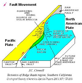 The Ridge Basin formed in the Late Miocene and Early Pliocene (~ 11 million years ago to ~4 million years ago). At that time most of the movement on the San Andreas Fault system occurred on the right lateral transform San Gabriel Fault, which is less than a mile to the east The San Gabriel Fault is not exactly straight (just as the San Andreas is also not straight). As a result, there are areas that push up against eachother creating hills and other areas are pulled apart creating depressions or basins. The green area in the figure represents the basin that was created in this area. It is is about 24 miles long, 6 miles wide and about 8 miles deep and has been named the Ridge Basin .
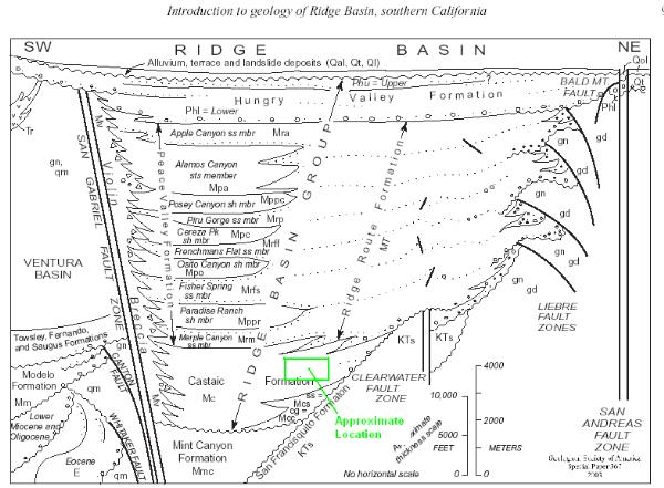
 As the basin formed, on the east side of the San Gabriel Fault where you are, it filled with sediments that eroded off of hills that formed on the north end of the basin. Most of the sediments came from the hills on the east side forming filling the center of the basin with fine grained sediments. However, along the west side, the granites and gneises in the hills formed steep hills that periodically filled the edge of the basin with a breccia. As the basin filled, movement on the fault carried sediments on the east side of the fault off to the south, extending the basin. The green square shows the approximate location of this outcrop within the Ridge Basin.
 In this section of the formation, the formation is made up of layers of mudstone with some siltstone. The layers in the road cut were deposited one on top of the other on a slight slope in the Ridge Basin. See diagram 1 in the cartoon figure.
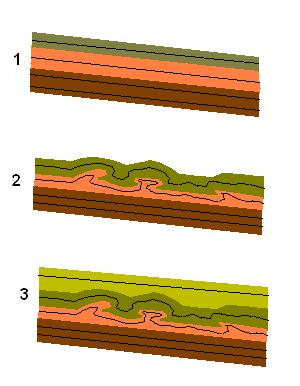 Periodically, something (such as an earthquake, which happens relatively frequently in this area) would destabilize these layers and the weight of the mud and silt on the slope would cause a mass of sediment to slide downhill along the top of one of the lower layers. The moving mass of sediment was cohesive enough and moved slow enough (geologically speaking) so that the individual layers remained stacked but folded up on themselves (Diagram 2). Then the next layer of sediment is deposited on top of the folded layer(s) (Diagram 3).
Logging requirements:
Send me a note with :
- The text "GC1W0HE Soft Sediment Deformation" on the first line
- The number of people in your group.
- Why do you think these folds are considered soft sediment deformation?
- How many folds do you see at this location?
The following sources were used to generate this cache:
- Link, M.H., and Crowell, J.C., 2003, Guide to field stops, Ridge Basin, southern California, in Crowell, J.C., ed., Evolution of Ridge Basin, southern California: Aninterplay of sedimentation and tectonics: Boulder, Colorado, Geological Society of America Special Paper 367, p. 205–247. © 2003 Geological Society of America
- Crowell, 2003, Introduction to geology of Ridge Basin, Southern California, Geological Society of America Special Paper 367, 2003
- Crowell, 2003, Tectonics of Ridge Basin region, Southern California, Geological Society of America Special Paper 367, 2003