|
História
O primeiro crescimento “moderno” de Coimbra deu-se com a abertura da Avenida Sá da Bandeira, em terrenos anteriormente pertença do mosteiro de Santa Cruz.
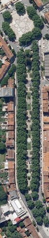
Seguiu-se a urbanização da chamada Quinta de Santa Cruz com aquela curiosa forma de estrela, que se pode notar a partir das imagens aéreas centradas na Praça da República.
Nos anos 40, Étiene De Groer, arquitecto e urbanista francês, vem para Portugal pela mão de Alfred Agache e faz o primeiro estudo sério da cidade, e lança as bases para o Plano Almeida Garrett dos anos 50.
Este, baseando-se no estudo de De Groer, faz a sua síntese em forma de plano eficaz que vai nortear todo o desenvolvimento de Coimbra até ao século XXI.
A Cache
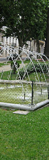
Esta é uma multi-cache, com o simples objectivo de vos levar a passear pelos jardins da Avenida Sá da Bandeira, chamando a atenção para vários pontos de paragem ao longo da subida.
Estacionamento - N 40° 12.684 W 008° 25.489
Existem vários pontos onde é possível estacionar ao longo da avenida. A nossa sugestão vai para o parque superior do Mercado Municipal, visto a primeira meia-hora de estacionamento ser gratuita.
Primeiro Ponto - N 40° 12.689 W 008° 25.442
A primeira paragem leva-vos ao monumento erigido a Camões.
Este monumento situava-se originalmente onde se construiu durante o Estado Novo a actual Faculdade de Letras, no alto da cidade.
Erigido originalmente por ocasião do 3º centenário da morte de Camões pelos estudantes de Coimbra, foi derrubado pelos operários que efectuavam a construção da nova faculdade.
Alguns anos depois, foi transferido para a rua do Arco da Traição (por trás do Departamento de Fisica) onde quase não era visivel.
Actualmente, encontra-se no inicio da Sá da Bandeira , local onde começamos esta multi-cache.
Sendo assim, tenho uma simples pergunta para vos fazer:
Qual o sexo do animal que se encontra representado no monumento?
Se for macho, A=2; Se for fêmea, A= 1.
Segundo Ponto - N 40° 12.631 W 008° 25.301
A segunda paragem vai levar-vos ao monumento erigido ao honra dos combatentes Portugueses que lutaram na 1ª Grande Guerra.
Portugal entrou oficialmente em guerra com a Alemanha em 9 de Março de 1916 (que já decorria desde Julho de 1914, com as hostilidades iniciadas entre a Austria-Hungria e a Sérvia), com a Alemanha a declarar guerra a Portugal por este ter confiscado todos os navios alemães ancorados em portos portugueses a pedido da Inglaterra.
A 9 de Abril de 1918 deu-se a pior batalha para as tropas Portuguesas, em La Lys. Gomes da Costa, que comandava os batalhões 7 e 21, pediu reforços que nunca chegaram - Sídónio Pais, o então Presidente da República e forte opositor à entrada de Portugal na guerra, não subscreveu o pedido de reforços. Sem reforços e frente a 8 divisões alemãs, as tropas desmoralizaram e a derrota foi a mais pesada registada por tropas portuguesas na guerra. As baixas e os prisioneiros portugueses foram muitos, e os militares sobreviventes foram integrados no exército inglês.
É no local deste monumento que vão responder à seguinte pergunta:
 |
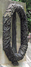
Quantas coroas de flores (esculpidas em bronze) se conseguem ver em redor do monumento? (exemplo do lado esquerdo)
A resposta a essa questão é B. |
Final
As coordenadas finais serão as seguintes:
N 40º 12.[Ax29][Bx3] W 008º 25.[Ax11][Bx2]
Trata-se de uma micro, com os conteúdos habituais - logbook, caneta e stashnote.
Ao reporem a cache no seu local, certifiquem-se de que não é visivel vista de cima (por causa dos muggles e da chuva).
Esperamos que tenham disfrutado do passeio e que tenham apreciado os jardins.
Até uma próxima oportunidade! :)
|
|
History
The first growth of the city of Coimbra during the modern times happened with the opening of the Sá da Bandeira avenue through the lands previously owned by the Santa Cruz monastery.
It was followed by the urbanization of the so-called Santa Cruz farm, in the curious shape of a star, which can be observed from the aerial photographs around the Praça da República.
During the forties, Étiene De Groer, french architect and town planner, comes to Portugal by the hand of Alfred Agache and does the first serious planning for the town, comming up with the groundwork for the Almeida Garrett Plan in the fifties.
Garrett, based on De Groer's study, wraps it up in an effective plan that will guide all of Coimbra's planning into the 21st century.
The Cache
This is a multiple-stage cache, with the sole objective of taking you for a walk along the gardens of the Sá da Bandeira avenue, drawing your attention to some stopping points along the route.
Parking - N 40° 12.684 W 008° 25.489
There are plenty of spots where you can park your car along the avenue. Our suggestion goes to the upper parking area next to the City Market, since the first half-hour is free.
First Stop - N 40° 12.689 W 008° 25.442
This first stop takes you to the monument dedicated to Camões.
This monument was originally located where the actual Faculty of Arts was built during the "Estado Novo" era, on the higher part of the city.
Built at the 3rd centenary of the death of Camões by the city students, it was knocked off by the workers who were building the new faculty.
Some years later, it was transfered to the Arco da Traição street (behind the Physics Department) where it was barely visible.
It's nowadays located at the beginning of the Sá da Bandeira , where we begin this multi-cache.
So, I have a simple question for you to answer:
What is the gender of the creature represented in the monument?
If it's male, then A=2; If it's female, then A=1. < /EM>
Second Stop - N 40° 12.631 W 008° 25.301
The second stop takes you to the monument built in honor of the Portuguese soldiers that fought during the 1st World War.
Portugal officially entered the war against Germany on the 9th March 1916 (which was already going since July 1914, with the initial hostilities between Austria-Hungary and Serbia), with Germany declaring war on Portugal because it had confiscated all of the german ships anchored at Portuguese ports following a request from England.
On April 9th 1918 there was the worst battle for the Portuguese troops, at La Lys. Gomes da Costa, which was commanding the 7th and 21st battalions, requested reinforcements which never came - Sidónio Pais, the then President of the Republic and a strong opponent against Portugal joining the war, didn't approve the sending of reinforcements. Without reinforcements and fighting against 8 german divisions, the troop's morale went down and their defeat was the heaviest suffered by portuguese troops in the war. There were heavy casualties and many were took as prisoners, and the surviving troops were integrated into the english army.
It's near this monument that you'll answer the following question:
How many wreaths (scuplted in brass) can you see around the monument? (example on the right side)
The answer to this question is B. |
|
Final
The final coordinates are as follows:
N 40º 12.[Ax29][Bx3] W 008º 25.[Ax11][Bx2]
It is a micro cache, with the usual contents - logbook, pen and stashnote.
When putting the cache back in its place, make sure it can't be seen from above (because of the muggles and the rain).
We hope that you have enjoyed your walk and that you have appreciated the gardens.
See you next oportunity! :)
|