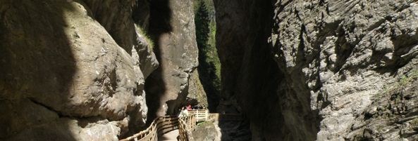
Die Liechtensteinklamm bei St.Johann i.Pg.
Grossarltal is one of the northern Tauern Valleys and flows south of St. Johann i. Pg. through the Liechtensteinklamm into the Salzach.
The 3 km long and up to 180 meters high gorge lies in the so-called Klammkalkzone. It belongs to the Radstätter Decke and separates the hull of the Hohe Tauern in the south of the so-called Grauwackenzone in the north.
The huge glaciers of the Ice Age formed under massive pressure an enormous Hängetal.
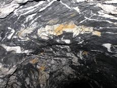
The main rock of the gorge is the Klammkalk, a dark gray, mostly fine-grained material, which occurs, depending on pressure and movement conditions, massive, stratified or slated. The Klammkalk is mainly crystalline, rich in Kalzitadern and acts very much alive. Morphologically of importance are the dark Phyllit- and Graphitic slate inclusions.
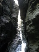

Shortly after entering the gorge is an enormous enlargement, which is marked by a strong gap and a giant armor wall. Then, the very narrow gorge will close with overhanging, almost touching cliffs. Here you can discover folded highly crystalline Klammkalk, which includes a lot of Kalzitreefs. Next it goes to the 2nd gorge expansion, where Kalkphyllitzonen occur in the Klammkalk. In the 3rd gorge expansion you can observe the occurrence of tectonically stressed Kalkphyllitinvolvement and a gigantic armor area.
Please answer the following questions:
1. When was the gorge opened up.
2. After whom is the gorge named.
3. Guess, how high is about the waterfall at the end of the gorge.
You must email me your answers to the questions in order to receive credit for this cache. A photo of you in front of the waterfall at the end of the canyon, at N 47°18.500 E013°11.600, holding your GPS out, is mandatory.Do not wait for my logpermission, if the answer or the picture is incorrect, I will contact you!!

Logs with no photo of the actual cacher logging the find or failure to answer questions will result in a log deletion. Logs with no photos will be deleted without notice.
Parking area: N 47°19.000 E 013°11.540
This EarthCache is intended for the entire family, but please use caution when attempting this EarthCache.
The cache can be done together with the cache Liechtensteinklamm by Die Feuerdrachen (GCZ7FE).
Die Liechtensteinklamm bei St. Johann i. Pg.
Das Großarltal ist eines der nördlichen Tauerntäler und mündet südlich von St. Johann i. Pg. in der Lichtensteinklamm ins Salzachtal.
Die 3 km lange und bis zu 180 Meter hohe Klamm liegt in der sogenannten Klammkalkzone. Sie gehört zur Radstätter Decke und trennt die Schieferhülle der Hohen Tauern im Süden von der sogenannten Grauwackenzone im Norden.
Die enormen Gletscher der Eiszeit formten unter massivem Druck ein gewaltiges Hängetal.
Das Hauptgestein der Klamm ist der Klammkalk, ein dunkelgraues, meist feinkörniges Material, das je nach Druck- und Bewegungsverhältnissen, massig, geschiefert oder geschichtet vorkommt. Der Klammkalk ist vor allem kristallin, reich an Kalzitadern und wirkt sehr lebendig. Morphologisch von Bedeutung sind die dunklen graphitischen Phyllit- und Schiefereinschaltungen. </ font>
Kurz nach Betreten der Klamm kommt es zu einer Klammerweiterung, die durch starke Klüfte und gigantische Harnischflächen gekennzeichnet ist. Anschließend wird die Klamm sehr eng, mit überhängenden, sich fast berührenden Felswänden. Hier kann man stark verfälteten und kristallinen Klammkalk entdecken, der reich an Kalzitadern ist. Weiter geht es zur 2. Klammerweiterung, bei der im Klammkalk Kalkphyllitzonen auftreten. Bei der 3. Klammerweiterung kann man das Auftreten einer tektonisch stark beanspruchten Kalkphylliteinschaltung und eine gigantische Harnischfläche beobachten.
Bitte beantworte folgende Fragen:
1. Wann wurde die Klamm erschlossen?
2. Nach wem ist diese Klamm benannt?
3. Wie hoch ist ca. der Wasserfall am Ende der Schlucht?
Um diesen Cache loggen zu dürfen, maile mir die Antworten. Bitte mach ein Foto von dir und deinem GPS beim Wasserfall am Ende der Schlucht bei den Koordinaten: N 47°18.500´ E 013° 11.600´, welches du deinem Log beifügst. Du brauchst meine Logerlaubnis nicht abzuwarten, wenn die Antworten oder das Bild falsch sind, melde ich mich bei dir!!
Logs ohne ein Foto von dir und ohne Beantwortung der Fragen werden kommentarlos gelöscht.
Parken kannst du bei: N 47°19.000 E013°11.540
Öffnungszeiten und Eintrittspreise bitte der offiziellen Homepage entnehmen.
Obwohl es sich um einen Familiencache handelt, ist Vorsicht geboten, da es sich durch das Sprühwasser in der Klamm teilweise um feuchten Untergrund handelt.
Der Cache läßt sich sehr gut mit dem Cache Liechtensteinklamm by Die Feuerdrachen (GCZ7FE) verbinden.
Happy caching
GRAC