Annapurna II EarthCache
-
Difficulty:
-

-
Terrain:
-

Size:  (not chosen)
Please note Use of geocaching.com services is subject to the terms and conditions
in our disclaimer.
During a tracking around the Annapurna you can do this earth cache.
After 5 days of walking from Bhulbhule you can chose to walk the
upper route to Manang. During your walk you will visit the cache
location with a beautiful view on Annapurna II and III.
Annapurna, part of the Himalayas, is a mountain massive with one of
the peaks above the 8000 meter elevation called Annapurna I (8091
meter), worlds 10th highest mountain on earth. Next to this peak
there are a lot of other peaks above 6000 meter.
The Himalayas is the worlds largest mountain with peaks reaching
over 8000 meter. Annapurna is Nepal smallest peak above 8000 meter.
The Himalayas originates from a collision of the Indian plate with
the Euroasia plate approximately 50 million years ago. Based on
vulcanism after the collision the Himalayas was formed with
multiple peaks. Annapurna is a massive with a lot of different tops
making it inpossible to have a view on all peaks on one single
place.
The Indian plate is still moving a few mm per year. This means that
the peaks in the Himalayas are still growing. The growth based on
the movement of the Indian plate is almost completely reduced to
naught due to the stark wind at top of the mountain.
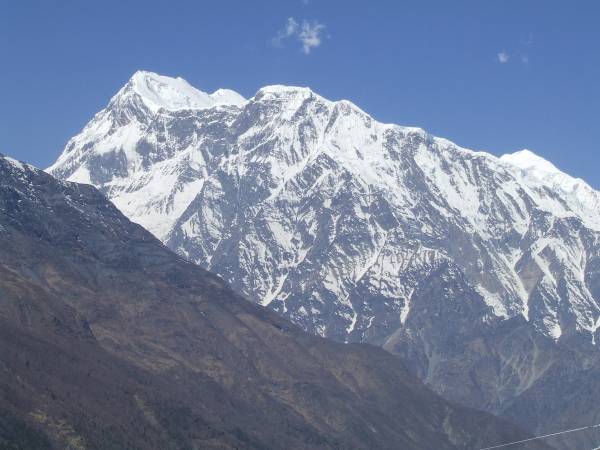
 View on Annapurna II
After 5 days of walking from Bhulbhule you will reach Lower Pisang.
Here you can chose to walk the upper route to Manang. During your
walk you will visit the cache location. Take a rest at the cache
location and order a drink. During your rest enjoy the beautiful
view on Annapurna II (7939 meter) and Annapurna III (7555
meter).
 View on Annapurna III
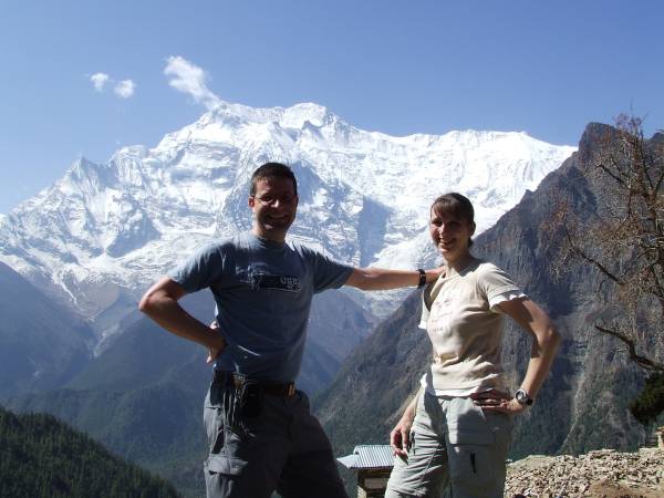
In order to claim this cache, you must have a photo taken with your
GPS and Annapurna II in the back ground. If the weather is so bad
that Annapurna II is not visible, then take a picture with the
typical tree at the cache location (a little bit to the right from
Annapurna II) in the back ground. You must also answer these
questions by sending me an email. (do not post the answers in your
log).
1. What is the name of the lodge at the given coordinates?
2. Which peak is visible at 250° from this location?
We appriciate your extensive log sharing your Nepal - Annapurna
experience!
Additional Hints
(No hints available.)