
Le gypse de Paris - Gypsum of
Paris
Principe:
Le plâtre est un liant hydraulique connu depuis l'Antiquité.
Il est fabriqué à partir d'une roche blanche et tendre à l'aspect
de sucre: le gypse, un sulfate de calcium hydraté (CaSO4 . 2 H2O).
L'eau représente le 21 % de cette pierre et c'est par sa
déshydratation partielle lors d'une cuisson qu'on obtient le
plâtre.
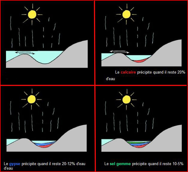
Le gypse fait partie de la famille des roches hydrochimiques
ou évaporites qui se forment à partir de saumures ayant atteint
leur point de saturation. Lorsque l'eau d'une lagune ou d'un marais
salant s'évapore sous l'action du soleil, des sels peuvent
précipiter (tomber au fond de l'eau).
On peut représenter l'histoire de ces dépôts
ci-dessous: |

Principle:
The plaster is one binding hydraulic known for the Antiquity.
It is fabricated to leave from a white rock and tend the aspect
sugar: The gypsum, a sulfate of hydrated calcium (CaSO4. 2 H2O.)
The water represents the 21 % of this stone and it is by its
partial dehydration at the time of a baking than the plaster is
gotten. The gypsum belongs to or having évaporites who form
themselves starting with brines reaches their point of saturation.
When the water of a lagoon or of a salting marsh evaporates under
the action of the sun, salts can precipitate (fall the water.) One
can represent the history of these depots below: |
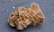
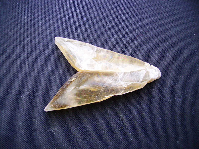
Le gypse peut cristalliser sous des
formes très diverses. The gypsum can crystallize under very diverse
forms.
 |
gypse saccharoïde, car rappelant la texture
du sucre en morceaux.
Gypsum saccharoïde, bus remembering
the texture of the sugar to pieces.
|
 |
Pied d'alouette ou Rose des sables.
Foot of alouette or Rose of the
sands
|
 |
Macle en fer Fer de lance.
Macle in iron Iron
throws.
|
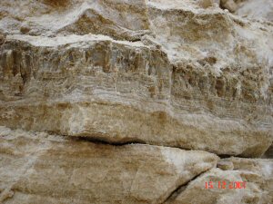
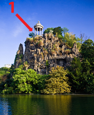
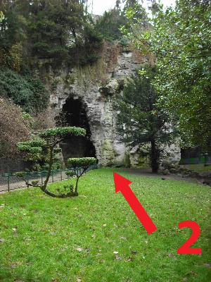
Affleurement de gypse des
buttes chaumont à Paris.
Comment ces crevasses, ces falaises, ces
éboulis de rochers et ces ravins ont-ils pu naître en plein Paris ?
L'endroit fut toujours accidenté, mais il était autrefois aride, et
c'est sur ce "mont chauve" que se dressaient des gibets.
Cette colline est un vestige géologique, une "butte témoin".
Pendant des dizaines de millions d'années des sédiments se sont
accumulés au fond des mers ou des lac qui recouvraient la région.
La mer allait et venait, déposant à chaque fois des débris sur le
fond. Ainsi se sont créées des couches d'argile, de sable, de
calcaire... Lorsque les eaux se furent définitivement retirées,
l'érosion détruisit, pendant des millions d'années, ce qui avait
été érigé. C'est ainsi qu'au cours de l'ère quaternaire, Paris prit
le relief que nous lui connaissons, avec quelques points hauts qui
ont mieux résisté à cette érosion intense, telles les Buttes. Le
quartier se révéla une source de richesse pour l'homme car, dans
ces diverses couches de terrain, se trouvaient des poches de gypse.
Porté à 120°C, le gypse se transforme en une poudre blanche, le
plâtre. Déjà les Romains décoraient les maisons de
Lutèce-la-blanche avec ce matériau. Plus tard,l e gypse des
Buttes-Chaumont acquit une excellente réputation : il était
régulièrement expédié aux États-Unis, d'où le nom de "quartier
d'Amérique" encore donné à tout le territoire situé entre la rue
Manin, la rue de Mouzaïa, et le parc (la station de métro Danube
est aménagée dans une ancienne carrière).
Le gypse apparaît en certains endroits sous la végétation. C'est un
gypse appelé "saccharoïde" car sa cassure ressemble à celle du
sucre. Il est blanc, mais l'altération et la poussière le rendent
grisâtre en surface. La dernière exploitation de gypse du quartier
fut fermée en 1873 et l'ensemble des carrières a été remblayé
depuis. Les accidents de terrain ont été utilisés pour donner au
parc l'aspect d'un paysage montagneux.
|
Gypsum outcrop of the buttes
Chaumont in Paris.
How these cracks, these cliffs, these falls of rocks and
these ravines did can exist in Paris? The place was always damaged,
but it was formerly arid, and it is on this “Buttes
Chaumont” that drew up gibbets.
This hill is a geological vestige, a “pilot
hillock”. During tens of million years of the sediments
accumulated at the bottom as of seas or of the lake which recovered
the area. The sea went and came, depositing each time remains on
the bottom. Thus created for themselves layers of clay, of sand,
limestone… When water had been definitively withdrawn,
erosion destroyed, during million years, which had been set up.
Thus during the quaternary era, Paris took the relief that we know
to him, with some high points who resisted this intense erosion
better, such the “Hillocks of Chaumont”. The district
appeared a source of richness for the man because, in these various
layers of ground, were gypsum pockets. Heated with 120°C, the
gypsum is transformed into a white powder, the plaster. Already the
Romans decorated the houses with Lutèce-the-white with this
material. Later, the gypsum of Hillock-Chaumont acquired an
excellent reputation: it was regularly dispatched in the United
States, from where the name of “district of America”
still given to all the territory located between the street Manin,
the street of Mouzaïa, and the park (the subway station the Danube
is arranged in an old career).
The gypsum appears in certain places under the
vegetation. It is a gypsum called “saccharoid” because
its break resembles that of sugar. It is white, but deterioration
and dust make it greyish on the surface. The last gypsum
exploitation of the district was closed in 1873 and the whole of
the careers was embanked since. The waves land were used to give to
the park the aspect of a mountainous landscape.
|

DECOUVERTE DES
LIEUX
Le croquis ci-dessus vous donnera une idée
du gigantisme des travaux réalisés et de la modification du
paysage.
Pour que la démonstration soit plus probante je vous
propose de vous rendre à deux endroits parmi les plus
représentatifs des lieux, ceci vous permettra d'examiner
directement la géologie et la hauteur de la falaise.
1° Aller au plus haut aux coordonnées du listing :
N48°52.863- E 02°22.981 c'est le temple de Sybille (par Davioud),
c'est une réplique de temple de Tivoli son soubassement est en
pierres du Jura. Lorsque vous êtes là-haut, n’oubliez pas de
jeter un coup d’œil sur Montmartre et surtout de noter
l'altitude précisée sur votre gps. Observer la forme géométrique de
la plaque métallique placée sur le sol au centre de ce
temple.
2° Aller au plus bas coordonnées N 48°52.801 – E
02°23.017. C'est l'emplacement précis de l'entrée de la carrière
souterraine au moment de la fin de l'exploitation des lieux en
1873. Cet accès est maintenant transformé en grotte. Noter
l'altitude précisée sur votre gps.
Pour valider votre découverte vous devrez
:
-A° m'indiquer par mail (Voir mon profil sur GC.COM -
Send message) le type de cristallisation du gypse à cet
endroit.
-B° M'indiquer qu'elle la forme géométrique de la plaque
métallique au centre du sol du temple et la hauteur totale de la
falaise obtenue par le gps.(Différence entre le point haut et le
point bas)
-C° Joindre à votre log une photo de votre gps ou de
vous même devant un endroit quelconque de la falaise du
gypse.
|

DISCOVERED PLACE
The sketch below will give you an idea of the gigantism
of work completed and modification of the landscape.
So that the demonstration is more convincing I propose
to you to go to two places among most representative of the places,
this will enable you to directly examine the geology and the height
of cliff.
1° To go to highest to the coordinates of the listing:
N48°52.863- E 02°22.981 it is the temple of Sybille (by Davioud),
it is a counterpart of temple of Tivoli its base is out of stones
of the Jura. You can see the air gypsum career. When you are up
there, do not forget to throw a glance on Montmartre and especially
to note the altitude specified on your gps. To observe the geometrical
shape of the metal
plate placed
on
the
ground in the center
of
this temple.To observe the geometrical
shape of the metal
plate placed
on
the
ground in the center
of
this temple.
2° To go with low coordinated the NR 48°52.801 - E
02°23.017. It is the precise site of the entry of the underground
gypsum career at the time of the end of the exploitation of the
places in 1873. This access is now transformed into cave. To note
the altitude specified on your gps.
To validate your discovery :
- A° to indicate to me by e-mail (See my profile on
GC.COM - Send message) the type of crystallization of the gypsum to
this place.
- B°To indicate to
me that
it forms
it geometrical
metal plate
in
the
center of the ground
of
the
temple and
the
total height
of
cliff obtained by the gps.
(Difference between
the
high point
and the low
point)
- C° To join to your log a photograph of your gps or you
even in front of an unspecified place of cliff of the
gypsum.
|
Acces et horaires. Le parc des buttes-chaumont :
Accès par les rues Manin et Botzaris (métro Buttes-Chaumont et
Botzaris) Le parc ouvre à 7h. Horaire de fermeture variable selon
la période :
Du 1er octobre au 30 avril : 20h30
Du 1er au 31 mai et du 1er au 30 septembre : 21h30
Du 1er juin au 31 août : 22h30
-----------------------------------------------------------------------------------------------------------------------------------------------------------------
Access and schedules. The park of buttes chaumont:
Access by the streets Manin and Botzaris (Subway
:Buttes-Chaumont and Botzaris) the park opens at 7:00. Variable
schedule of closing according to the period:
From October 1st to April 30th: 20:30
From May 1st to 31st and from September 1st to 30th: 21:30
From June 1st to August 31st: 22:30
| Rappel
concernant les « Earthcaches »: Il n'y a pas de conteneur à
rechercher ni de logbook à renseigner. Il suffit de se rendre sur
les lieux et d'exécuter les requêtes du geocacheur (par exemple
l'envoi d'un mail pour validation) BON
GEOCACHING |
| Reminder concerning "Earthcaches":
there is neither a container to look for nor a logbook to sign. One
need only go to the location and fulfill the requests of the owner
(for example the sending of an e-mail for validation) HAPPY
CACHING |
| I am a proud |
 |