A Cova-Gala
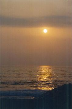
Situada na margem sul do Rio Mondego, junto à foz do mesmo, implantada entre o mar, rio e pinhal.
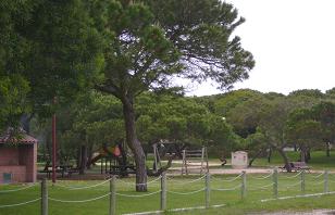
As suas origens piscatórias remontam ao século XVIII, sua principal actividade até á década de oitenta do século XX. As suas potencialidades naturais como os seus cinco quilómetros de praias a poente, de areia branca e fina, com água transparente de boa qualidade, o mar com excelentes condições para a prática de desportos radicais, o Rio Mondego, que a margina a norte e a nascente, permite: prática de pesca desportiva, de vários desportos náuticos, assim como outros motivos lúdicos e de lazer. O pinhal a sul, com o seu magnífico parque de merendas têm contribuído para o incremento de um enorme movimento na área do turismo.
In www.spcovagala.com/ 2009-04-18
 A História
A existência do povoado da Cova remonta a meados do século XVIII, quando pescadores oriundos das cercanias de Ílhavo, nas suas andanças pela orla costeira, na procura de melhores zonas pesqueiras, acabaram por se fixar junto á margem sul do Rio Mondego, muito perto do mar, na cava de uma duna, facto que deu origem ao topónimo de Cova.
A povoação, inicialmente formada por palhoças de junco, muito abundante nas dunas, foi incendiada pelos seus moradores no período das invasões francesas, quando uma companhia das tropas de Junot, se aproximava da localidade, retirando-se os pescadores nas suas bateiras, para a ilha da Murraceira, onde permaneceram até à retirada dos invasores, que não demoram muito tempo nesta área inóspita.
Com a zona livre das tropas inimigas, os pescadores regressaram da Murraceira, dando de imediato, inicio á construção já no lugar definitivo das suas casas em madeira, assente em estacaria elevadas do solo, para que as areias das dunas frequentemente movidas pelos ventos não as soterrassem.
A Gala nasce anos depois quando estes pescadores se deslocam mais para nascente aproveitando as enormes potencialidades que o rio oferecia construindo as suas casas junto ao braço sul do rio do Mondego, assim como armazéns para guarda dos seus apetrechos de pesca, salga e comercialização da sardinha provenientes das diversas artes. A implantação dos Estaleiros Navais, na Murraceira, contribuiu para um rápido povoamento da Gala.
Com o decorrer dos tempos, estas duas povoações foram crescendo ao encontro uma da outra, formando hoje um só aglomerado populacional a que nos habituamos naturalmente a chamar Cova Gala.
A escolha de São Pedro seu padroeiro, para nome da Freguesia, foi por ser o mais consensual entre os habitantes da Cova e da Gala. Este povo, de origens únicas, que vivia outrora separado por uma pequena faixa de areia sem nunca assumir verdadeiramente onde começava uma povoação e acabava outra, nutriu ao longo dos tempos imensas rivalidades, muitas provocadas por bairrismos exagerados relacionadas com as colectividades e pelos seus ranchos folclóricos. Essas disputas foram-se diluindo com o tempo, estando hoje completamente desvanecidas, tendo contribuído para esse facto, a criação da Freguesia com o nome de São Pedro, o verdadeiro elo de união deste povo.
In www.spcovagala.com/ 2009-04-18
A Cache
A coordenada inicial indica a localização do parque de merendas.
Esta e a segunda coordenada dizem respeito aos locais onde encontrarão as respostas para obter as coordenadas da cache final.
O primeiro local é uma bela ajuda aos veraneantes para fugirem do sol, aproveitando as belas sombras e todo os equipamentos existentes.
O segundo local é uma casa típica que fica a cerca de 500 m do parque de merendas, junto à praia da Cova.
A Cache encontra-se num local onde poderão encontrar uma bela vista sobre o mar, a Figueira da Foz e a Serra…A cache não está nas dunas, que são zonas protegidas...
É tudo ao ar livre… tragam lanche para o pic-nic e a toalha para a praia! Deixem as vossas fotos e obrigado pela vossa visita!! Esperamos que gostem!!
Agradecemos toda a vossa atenção e cuidado quando tiverem junto da Cache, pois é um local muito frequentado. P.F. recoloquem a cache no mesmo local e nas condições em que a encontraram. Obrigado!
ENGLISH
Cova Gala
Located on the south bank of the Mondego river, near the mouth of it, located between the sea, river and pine trees. Its origins date back to the eighteenth century fishing, their main activity until the eighties of the twentieth century.
Their potential as natural their five kilometers west of the beaches of white sand and fine, with transparent water of good quality, the sea with excellent conditions to practice sports, the Mondego river, the marginalized to the north and east, allows for: practice of sport fishing, several water sports and other entertainment and leisure reasons.
The pine trees to the south, with its magnificent park of snacks have contributed to the development of a huge movement in the area of tourism.
In www.spcovagala.com/ 2009-04-18
History
The existence of the village of Cova back to the middle of the eighteenth century, when fishermen from the surroundings of Ílhavo in its vicissitude the coastline in search of better fishing areas, eventually will be fixed along the south bank of the Mondego river, very close to the sea, in a dune cava, which resulted in the toponymy of Cova.
The town, originally formed by straw of junk, very abundant in the dunes, was burned by its inhabitants during the French invasion, when a company of troops of Junot, approached the town, taking up the fishermen in their boats to Murraceira island, where they remained until the withdrawal of the invaders, which does not take long in this inhospitable area. With the area free of enemy troops, the fishermen returned to Cova, giving immediately, will start construction now in its final place in wooden houses, built in Cuttings high ground, so that the sand dunes often moved by the winds do not buried.
The Gala was born years later when fishermen move to source more advantage the huge potential that the river offered by building their homes along the southern arm of the Mondego river, and warehouses to store their fishing gear, curing and marketing of sardines from the various arts.
With time, these two villages were growing to meet each other, forming a single cluster population today to get used to naturally draw Cova Gala.
The choice of patron St. Peter, to name the town was to be the consensus among most people in Cova and Gala. The people of unique backgrounds, who lived formerly separated by a small strip of sand without ever truly take a village where he started and had another, nourished over time many rivalries, many caused by excessive localism related communities and their ranches folklore. These disputes were diluting it with time and are now completely blurred, and this contributed to the creation of the Town with the name of St. Peter, the real bond of union of this people.
In www.spcovagala.com/ 2009-04-18
The Cache
The initial coordinate indicates the location of the park to picnic.
This coordinated and the second relates to where you find the answers to get the coordinates of the final cache. The first is a beautiful place to help holidaymakers to escape the sun, enjoying the beautiful shadows and all existing equipment. The second site is a typical house that is about 500 meters from the park to picnic at the beach of Cova.
The Cache is in a location with a beautiful view over the sea, Figueira da Foz and Serra da Boa Viagem ... Warning, do not go in the dunes, are protected areas ... .
Stage 1 - Park (N 40° 07.452 W 008° 51.582)
At this point you have to discover and count the number of feet on a wooden bridge (A) and the number of "water volcanoes" (today there is no water) (B).
Stage 2 - Typical house (N 40° 07.539 W 008° 51.796)
Count the number of cuttings of the typical house (C).
The cache is at:
N 40º 7.(572 + A - B); W 008º 51.(957 - (A x C) )
To confirm equation: A x C = (B x C) + 98.
It's all outdoors ... bring snack for the picnic and towel for the beach! Let your pictures and thanks for your visit! We hope you enjoy!
Thank you all for your attention and care when near the Cache, it is a highly frequented place. Please replace the cache in the same location and under conditions in which they found. Thank you!
