
HURKY - natural monument
The natural monument was established for the
protection of communities of hydrophilic and moorland vegetation on
springs of fissure water with a number of rare and protected
peatland species. It is located in the cadastral district of Hurky
u Zahrádky at an altitude of 538–553 m.
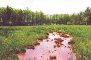
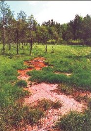
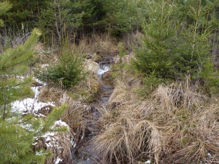
The moorland developed on a point of contact of a striped zone
where surface rising of water, heavy waterlogging of the bottom of
a furrow and gradual overgrowing with herb vegetation take place. A
broad range of predominantly hydromorphic soils, mainly gleys,
pseudogleys and, to no small extent, also typical Histosol
developed here.
The area is covered with
a mosaic of various types of peat bogs and moors gradually being
overgrown by a wetland alder thicket . A fragment of a moor grass
meadow has survived in the southern part of the area, and remains
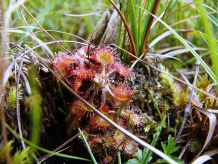
of peatland pinewoods have survived in the peripheral parts. Of
specially protected plant species, e.g. the dioecious sedge
(Carex dioica), marsh lousewort marsh gentian (Gentiana
pneumonanthe), round-leaved sundew (Drosera rotundifolia),
marsh grass of Parnassus (Parnassia palustris), common
butterwort (Pinguicula vulgaris), western marsh orchid
(Dactylorhiza majalis), bogbean (Menyanthes trifoliate) and
mezeron (Daphne mezereum) occur here.
The territory is also interesting from an entomological point of
view.
Hurky was declared a national monument as early as in 1955 (update
in 1988).
To log this
earthcache find, you must fulfill the following
requirements:
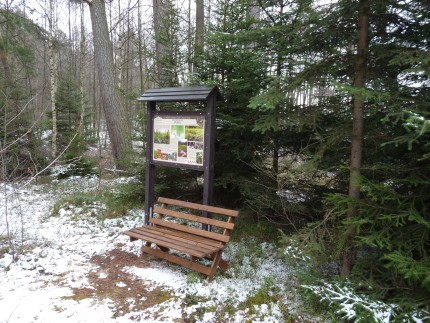
1.Add your photo and a photo of a GPS device at the information
plate to the logo
- answer these
questions:
2.What made the development of the peat bogs possible?
3.What constitutes the basis of natural rock
monuments?
The answers to the
questions please send via e-mail in my profil,
thanks.

HURKY - prirodni pamatka
Prirodni
pamatka byla zrizena k ochrane spolecenstev vlhkomilne a slatinne
vegetace na pramenech puklinove vody s radou vzacnych a chranenych
raselinistnich druhu. Nachazi se v k.u. Hurky u Zahradky v
nadmorske vysce 538 -553 m.
Slatiniste vzniklo na
styku pricne zony, kde dochazi k plosnemu vyveru vody, silnemu
zamokreni dna ryhy a postupnemu zarustani bylinnou vegetaci.
Vyvilulo se zde siroke spektrum prevazne hydromorfnich pud, hlavne
gleje, psedogleje a v nemalem meritku take organozem typicka. Uzemi
je pokryte mozaikou ruznych typu raselinist a slatinist
prerustajici postupne mokradni olsinou. V jizni casti se dochoval
fragment bezkolencove louky a v okrajovych partiich zbytky
raselinnych boru.
Ze zvlaste chranenych druhu rostlin zde roste napr. ostrice
dvoudoma (Carex dioica), vsivec bahenni (Pedicularis
palustris), horec horepnik (gentiana pneumonanthe),
rosnatka okrouhlolista (drosera rotundifolia), tolije
bahenni (Parnasia palustris), tucnice obecna (Pinquicula
vulgaris), prstnatec majovy (Dactylorhiza majalis),
vachta trojlista (Menyanthes trifoliata), lykovec
jedovaty (Daphne mezereum).Uzemi je zajimave i z hlediska
entomologickeho.
Prirodni pamatkou byly Hurky vyhlaseny jiz v roce
1955 (novelizace 1988).
K uznání logu
musíte navštívit prirodni pamatku Hurky a splnit následující
úkoly :
- 1. K logu pripojte fotografii Vas a prístroje GPS u informacni
tabule.
- odpovedet na otázky :
- 2. Co umoznilo rozvoj raselinist?
- 3. Co tvorí horninovy podklad prirodni pamatky
Hurky?
Odpovedi mi zaslete pres profil na muj email,
diky.
WWW
pocítadlo teto stranky ríka, ze jste navstevnik cislo 