![]()
![]()
 Der Toteiskesselweg
Toteiskessel – im Volksmund auch Mösel (bayerisch) oder Söll (norddeutsch) genannt – sind trockene, sumpfige oder mit Wasser gefüllte Senken, die durch Abschmelzen von Toteis entstanden sind. Toteis wiederum ist eine Bezeichnung für Eisblöcke, die vom Gletscher abgetrennt und von Schmelzwassersedimenten überdeckt wurden. Unter der isolierenden Schotterdecke schmolzen die Eisblöcke langsam – über Jahrhunderte – ab. Der Schotter sackte nach, und eine Hohlform, der sogenannte Toteiskessel, entstand. Toteiskessel treten typischerweise im Bereich von Endmoränen auf – so wie das für Haag zutrifft.
Diese Information haben die Agenda21und Bund Naturschutz in Bayern e.V. eingerichtet, um ergänzende Informationen über Toteiskessel, Gletscher und vieles mehr bereitzustellen. Dieses Projekt wurde mit den Mitteln der EU aus LEADERplus gefördert.
Dieser deutschlandweit einmalige Toteiskesselweg ist ca. 4.5 km lang. Die Wanderung dauert maximal. 2.5 Stunden und führt über unbefestigte Wiesen- und Waldwege durch eine abwechslungsreiche Landschaft. Entlang des Wanderweges markieren nummerierte Findlinge die Toteiskessel. Informationen zum Wegeverlauf, zu den einzelnen Toteiskesseln und weiteren Sehenswürdigkeiten befinden sich in den Faltplänen an der Infotafel am Parkplatz N 48 ° 09.759 E 012 ° 11.722 oder unter http://www.toteiskessel.de.

Um diesen Earthcache zu loggen, müssen folgende Bedingungen erfüllt sein
1. Beantworte die folgende Fragen und sende die Lösung über Geocaching.com (send message) per Mail und warte unbedingt die Log-Erlaubnis ab:
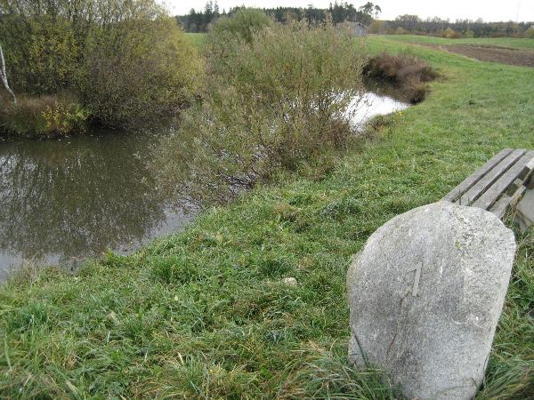
a.) Aus welchem Material ist der Findling beim 1. Toteiskessel ?
b.) Ist der Toteiskessel # 1 immer wasserführend?>
c.) Wie heißen die Pflanzen, die in der Mitte des Weihers wachsen?
2. Fotografiere Dich oder Dein GPS am Toteiskessel # 1, als Beweis, dass Du selbst da warst (optional).
 The Kettle Hole Trail
The Kettle Hole Trail has been created to draw attention to the kettle holes found 45 km east of Haag. Kettle holes are hollows formed by the melting of detached blocks of glacial ice buried in moraines or in gravel and debris borne by streams emerging from a glacier. When the block of ice melts, a process that can take several decades, the debris settles and a hollow is formed. Haag and the Kettle Hole Trail are located on the terminal moraine that marks the furthest extent of the Inn-Chiemsee Glacier during the last Ice Age (some 20,000 years ago). Kettle holes can be dry, marshy or contain water, and can range greatly in size and depth.Since kettle holes occur only in glacial landscapes, they are not common natural features.
Over the past hundred years or so, the kettle holes around (and in in general) have increasingly disappeared due to filling and levelling or other agricultural practices. They are characterised by specific microclimatic conditions and thus support a distinctive assemblage of plants and animal species, many of them regionally rare. The nine kettle holes along the trail occur in a glacial landscape marked by mounds and basins, as is particularly visible in the café area.
The Kettle Hole Trail is the work of two local groups – a local chapter of Bund Naturschutz, a Bavarian nature conservation association, and Agenda 21-Haager Land , an Agenda 21 group of volunteers who got together in 1999 to implement ways of sustaining the economy and the environment in the Haag district. Fifty percent of the funding came from the European Union as part of the EU Community's Leader+ initiative for rural development, and much support has been provided by local experts, farmers, businesses, politicians and volunteers.
This Kettle hole Trail, unique in Germany , is approx. 4,5 km long. The walk will last at most 2,5 h and leads you across meadows and forest paths through a varied scenery. Along the trail the kettle holes are marked by numbered erratic boulders. Information about the route, each kettle hole and other sights can be found in the maps available at the parking lot N 48 ° 09.759 E 012 ° 11.722 or under http://www.toteiskessel.de
To log this Earthcache the following conditions must be fulfilled:
1. Answer the following questions and send the solution with geocaching.com (send message) by mail and wait for the log permission:
a.) Of which material is the boulder of the kettle hole # 1?
b.) Is the Kettle hole # 1 always aquiferous?
c.) What is the name of the plants growing in the middle of the pool?
2. Take a picture of you or your GPS with the boulder of # 1 as a proof that you visited it yourself.