|
"The most mysterious architecture by
the most mysterious of architects, nature's coliseum,
Gavarnie…"
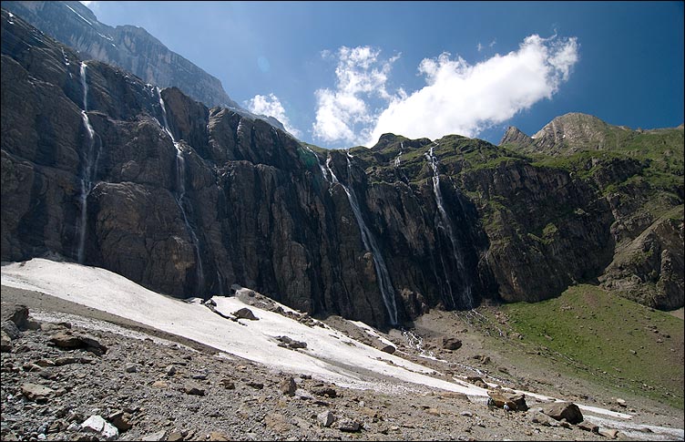
The Cirque
de Gavarnie is a famous example of a cirque in the
central Pyrenees, in the Pyrenees National Park. The cirque
is 800 m wide (on the deepest point) and about 3000 m wide at the
top. The Cirque de Gavarnie is placed about 4 km south of
the village Gavarnie. From its floor, glacially eroded limestone
rock walls rise to about 1500 m. It has three conspicuous terraces
in which precipitous faces are succeeded upward by steep slopes of
ice and snow. The Grande Cascade waterfall, one from the
largest waterfalls in Europe, plunges about 425 m from the eastern
side. Above the amphitheatre are the high mountain summits of the
Franco-Spanish frontier ridge, rising to nearly 3 350 m (the
Large peak of Astazou, the Peak of Marboré, the
Peak of the Eastern cascade, the Turn of Gavarnie,
the Helmet of Gavarnie and the Peak of Taillon). Also
conspicuous is the deep cleft known as the Breche de Roland.
Nearby is cave Grotte Casteret, containing a frozen
underground stream. This magnificent piece of Nature has been
recently recognized as UNESCO World Heritage site. The
Cirque de Gavarnie is one of the most visited sites in the
Pyrenees.

A cirque (French for "circus") is an
amphitheatre-like valley, or valley head, formed at the head of a
alpine glacier by erosion. A cirque is a landform found in the
mountains as a result of alpine glaciers. They can be up to a
square kilometers in size, situated high on a mountain side near
the firn line, and are typically partially surrounded on three
sides by steep cliffs. The highest cliff is often called a
headwall. The fourth side is the "lip" which is the side that the
glacier flowed away from the cirque. Many glacial cirques contain
tarns dammed by either till or a bedrock threshold. When enough
snow accumulates it can flow out the opening of the bowl and form
valley glaciers which can be several kilometers long.
Cirques form in conditions which are
favorable; which in the northern hemisphere includes the north-east
slope where they are protected from the majority of the sun's
energy and from the prevailing winds. These areas are sheltered
from heat, encouraging the accumulation of snow; if the
accumulation of snow increases, the snow turns into glacial ice.
The process of nivation follows, whereby a hollow in a slope may be
enlarged by freeze-thaw weathering and glacial erosion. The
freeze-thaw erodes at the lower rocks and causes it to
disintegrate, which can result in an avalanche bringing down more
snow and rock to add to the growing glacier. Eventually, this
hollow can become big enough so that glacial erosion intensifies.
Debris (or till) in the ice may also abrade (glacial abrasion) the
bed surface; should ice move down a slope it would have a
"sandpaper effect" on the bedrock beneath on which it scrapes.

Additional information you can
find on info-board at N42° 42.242' W0° 00.482'.
For the valid "cache found"
log:
1) you have to upload a photo of you with
GPS close to the cache coordinates
2) and send me via e-mail answers to these
five questions:
- when were deposited here sediments creates Cirque (approx.; in
millions years B.C.) ?
- when was the cirque created (approx.; in thousands years B.C.)
?
- what is the name of famous French 19th century writer - author
of the first sentence in the listing ?
- what is the name of the small bridge at coordinates N42°
42.161' W0° 00.399' ?
- what is the main mineral which creates Cirque ?

|