Arbel Cliffs Traditional Cache
-
Difficulty:
-

-
Terrain:
-
Size:  (small)
Please note Use of geocaching.com services is subject to the terms and conditions
in our disclaimer.
Mt. Arbel - ??
????
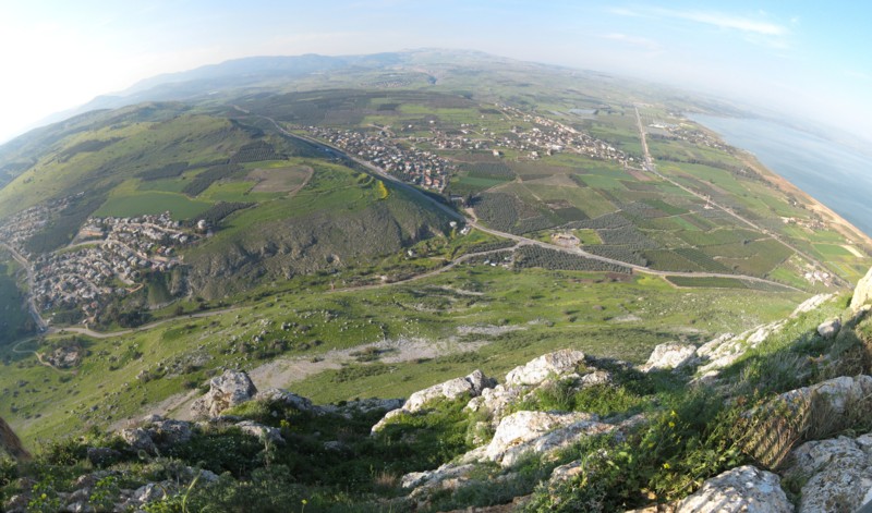
One of the most spectacular views and breathtaking panoramas in
Israel can be found here in the lower Galilee region. Like so many
other places in Israel, however, the view gives no hint of the rich
Jewish history lying beneath the surface.
Mount Arbel (or Har Arbel) is a mountain in The Lower Galilee near
Tiberias in Israel, that has split into two after an earthquake.
The other half of is Mt. Nitai. On the mountain there are four
settlements: Kfar Zeitim, Arbel, Kfar Hittim, and Mitspeh. The
peak, at 282 meters above sea level (481 meters above the
surrounding area), dominates the entire surroundings (much of the
area is below sea level) and from the lookout atop the mountain,
one can see almost all of the Galilee into the Golan Heights
including Safed, Tiberias and most of the Sea of Galilee.
Near the mountain remain the ruins of an ancient Jewish settlement
including a Synagogue from the fourth century C.E. with extend pews
and columns, and dug into the mountain itself are a number of cliff
dwellings. The extant cliff dwellings are from the 17th century and
were built by the Druze though there are documented Jewish cliff
dwellings dating back to the Second Commonwealth in the area.
Josephus writes about the Roman conquest of some of the last
Hasmonean rebels who dwelt in the cliffs of Mt Arbel.
On the south side, there is a gradual prolonged climb through
agricultural and pasture land while on the other, there is a very
steep 400 meters drop. At the top of the steeper Northern side,
there are metal handholds driven into the rock because the climb is
so steep. Below that are a series of switchbacks that eventually
lead to the Bedouin village of Hamaam.
The famous Battle of Hittim (or Hattin) - also known as "The Horns
of Hittim" (or Hattin) because of a nearby extinct volcano of the
same name - took place on Saturday, July 4, 1187, between the
Crusader Kingdom of Jerusalem and the forces of the Ayyubid
dynasty.
The Muslim armies under Saladin captured or killed the vast
majority of the Crusader forces, removing their capability to wage
war. As a direct result of the battle, Islamic forces once again
became the eminent military power in the Holy Land, reconquering
Jerusalem and several other Crusader-held cities.
In 2008, it was announced that a new golf course resort would be
constructed at a cost of $150 million, on land owned by Kfar Hittim
on Mount Arbel. The resort which should open in 2011, will cater
for between 600-900 people as well as creating 300-400 jobs.
Mt. Arbel, with its 110 meters vertical drop, is the only known
mountain in Israel to serve as a base jumping site. The hike to the
top of Mount Arbel is included in the Israel National Trail.
The spring is a beautiful time for a visit to this spot. The hills
and fields are awash with color after the winter rains, and it is
not yet too hot to hike in this region of the country.
The scoring of difficulty and terrain is variable: If you come by
tourist bus it is only a short easy walk. On the other hand, if you
start from the base of Arbel it is a significant hike.
You can reach the cache through a buil-up area. Here you have to
pay for the services, and you have to count with regulated opening
hours as well. However the blue, black trails, and Israel National
Trail can lead you to the cache for free (without extra
services).
Please be careful. The cache is near to the
edge.
Related links:
Israel National
Trail
Israel
National Trail - Wikipedia
Mt Arbel -
Wikipedia
Jesus Trail
Jesus
Trail - Mt Arbel
Mt Nitai -
Wikipedia
Battle of
Hattin - Wikipedia
Youtube
Please note that it's not an abandoned vacation cache, as I
asked at first some kind of approval from local geocachers, and
Irisvo and Isracacher kindly offered their help in maintenance.
Many thanks for them.


Additional Hints
(Decrypt)
Va n ubyr haqre/orgjrra gjb ovttre ebpxf, pbirerq ol fgbarf. Frr fcbvyre vzntrf.