ONEONTA TUNNEL
 The Historic Columbia River Highway's alignment from Crown Point, milepost 23.9, to Horsetail Falls Bridge, milepost 34.6, takes the highway along one of the largest concentrations of high waterfalls in North America. Near its eastern end lies Oneonta Creek and Gorge. The name ''Oneonta,'' according to Oregon Geographic Names originates in Oneonta, New York, and means "place of peace". The Oregon Steam Navigation Company ran a sidewheeler named Oneonta on the Columbia, above and below its cascades, in the 1860s and 187Os. Oneonta Creek and Gorge probably were named sometime after the boat's construction.
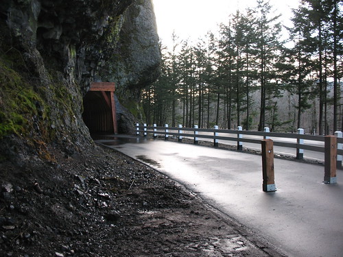
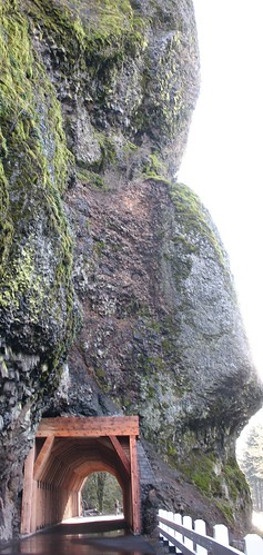
In 1914, the Multnomah County Road Department and Samuel Lancaster sought to align the route so that it brought travelers to the mouth of Oneonta Gorge, a canyon so narrow that its basalt walls almost touch as they rise two hundred feet above the creek. Subsequently, the county built Oneonta Gorge Creek Bridge. Carrying the alignment past a nearby 200' bluff, a continuation of the Oneonta Gorge, proved more difficult. In the 1880s the Oregon-Washington Railroad and Navigation Company (OWRN) had laid out its route along the Columbia River's south shore. Much or it was along the old Troutdale to The Dalles road begun in the 1870s. The OWRN's right-of-way crossed Oneonta Gorge Creek then passed through a narrow opening between the river and the bluff before continuing east. With the close proximity of the river and the cliff, there was no additional space to permit carrying the HCRH around the outcropping.
Determined to include Oneonta Gorge and nearby Horsetail Falls as two of the natural beauty spots on the HCRH's route, Lancaster resolved this dilemma by having a tunnel bored through the outcropping.
Plans stipulated creating an alignment that included a bridge over Oneonta Gorge Creek parallel and to the south of the railway span, and continuing east through the rock wall via a 125' tunnel. The Multnomah County Road Department called for bids in late 1913, and by the end of the year it had received contract proposals from 12 firms. Of these, S. P. White and company of Vancouver, Washington, had the low bid.
The S. P. White Company completed the Oneonta Tunnel during 1914 at a cost of $6,684.88. This included $4,140.00 for cutting the tunnel, $523.05 for excavating the portals, and $1,723.29 for 61,546 board feet of timbering. The tunnel, however, was not immediately opened to traffic. The Construction Company of Portland did not complete an 80' reinforced-concrete deck girder bridge over Oneonta Gorge Creek near the tunnels west portal until later in the year.
 The Oneonta Tunnel served on the Historic Columbia River Highway from 1914 until 1948 when a highway realignment bypassed it. Maintenance records for the tunnel do not survive, but drawings from 1931 suggest that it was relined that year, most likely because the original timber sets and lagging had rotted from moisture penetration.
Oneonta tunnel's lining reduced its clear dimensions. Its roadway width became 16'-9". Horizontal clearance at the curb line was about 10' and 16' at the centerline. By the mid-1930s, with greatly increased traffic volume, and larger vehicles, Oneonta tunnels vertical and horizontal clearances were too small to safely accommodate two-way traffic. In July 1936, the Oregon State Highway Department installed traffic activated one- way stop-and-go signals at the tunnel portals, temporarily solving the traffic safety problems.
Rock fall due to frost was a continual problem at Oneonta Tunnel. Chunks of basalt filled the cavity between the tunnel bore and the lining and dropped on the roadway at the portals. The greatest concern was the perennial covering of the OWRN (later Union Pacific Railroad) main line with rock tumbling off the cliff.
In 1948 the railroad saw an opportunity to end its worries about the tunnel by moving its trackage north of the cliff on fill dredged from the Columbia. This created room for the highway department to re-route the HCRH around the cliff on the old railroad right-of-way. The state then mothballed the tunnel with fill to prevent continuous raveling and possible collapse. The highway department constructed a new bridge, on the old railroad span's original piers as part of the realignment, and retained the old bridge and adjacent abandoned roadway as a parking area for travelers to Oneonta Gorge.
Restoration
These days, the historic highway, including pieces abandoned when Interstate 84 was built, is a national treasure. The Columbia River Highway was the first scenic highway in the United States and is on the National Register of Historic Places.
In August 2006 when Oneonta’s restoration began, workers pierced the piles of rock inside and saw light at the end of the tunnel for the first time since 1948. The $1.6 million restoration, which included retimbering the interior of the tunnel, provides pedestrian access to a new parking area on the east side for Oneonta Gorge users. The steep, narrow canyon is a favorite retreat on hot summer days. The project also strengthened the Oneonta Creek Bridge and restored the stream bank. Oneonta is home to endemic plants that grow only in the gorge.