Rhododendron Rock at Mount Rogers EarthCache
Rhododendron Rock at Mount Rogers
-
Difficulty:
-

-
Terrain:
-

Size:  (not chosen)
Please note Use of geocaching.com services is subject to the terms and conditions
in our disclaimer.
At the Grayson Highlands Park, park at the Massie Gap
parking area (see coordinates). Take the Rhododendron Trail to the
AT Trail (white blaze). You are heading toward the Thomas Knob
shelter and then if you are going to the top, take the Mt. Rogers
Spur Trail. This cache is approximately one half way to the summit.
Difficult hike.

Rhododentron Rock
Many millions of years ago, the Appalachian Mountain chain
was formed when North America was part of the supercontinent
Pangaea. Huge tectonic plates pushing against each other caused an
up rift and large land masses were ‘forced’ upward to
form the mountains. During this time, subterranean (very deep)
pressures broke through the surface to emit lava. Yes, lava as in
volcanoes! Very few people know that this part of the Appalachian
Mountains known as the Mount Rogers Chain is actually extinct
volcanoes. Since the last eruptions occurred millions and millions
of years age, there is a almost zero probability that there will be
future eruptions. At one time, these mountains were much higher in
elevation. During millions of years of erosion from wind and water
the size has been reduced by much more than one half.

Pangaea
How do we know that volcanoes were here and created the
current landscape? That is where geology comes in. Geologists have
studied the rocks and minerals that are found in the Mount Rogers
area. What have they found? No smoldering volcanoes, no flowing
lava and no enormous gas/smoke plumes in the air were found. What
was/is found is the aftermath of all of those
events………..rocks! It is within those rocks
that the ancient history can be determined. The rocks here and
‘our’ Rhododendron Rock are created by one
thing, volcanoes. They are not sedimentary and few are metamorphic,
they are igneous rocks from volcanoes!

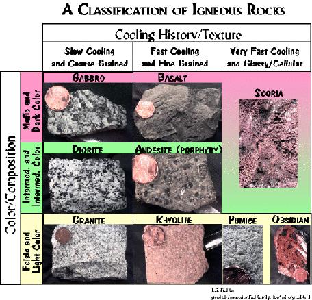
The Formation Of Igneous
Rocks
Just what is the nature of these igneous rocks including
the Rhododendron Rock? Igneous rocks are either intrusive or
extrusive. Intrusive igneous rocks are part of the super heated
magma that remains below the Earth’s surface. On the other
hand, extrusive igneous rock is emitted from the volcano to flow
and/or fly onto the surface. By and large, these are the type of
rocks found on Mount Rogers and compose the Rhododendron
Rock.In order to illustrate the differing types of igneous
rocks, please refer to the diagram below.
The Rhododendron Rock is part of the larger
formation known as the Rhododendron Gap. As you are hiking up from
Massie Gap toward the Mount Rogers summit, there more than one
large outcroppings. While the trail takes you to the
Rhododendron Rock you will pass other wonderful but unnamed
outcrops. There is no reason why you cannot take side trips to
observe and photograph them. All are the productions of very active
volcanoes. Notice the rocks that you must climb and walk on. One
day, they were molten lava and you wouldn't’t be touching
them!
Be very careful during this hike. At times the footing is
loose and very often you will transverse large boulders and slick
surfaces. This is not a trip for small children and we do not
recommend that you bring them. If they do accompany you, please
go slow and add an extra hour or more each way. Taking your time
and assuming you will want to go to the summit, plan for at least 5
to 6 hours at a minimum. The weather can and does change quickly so
dress appropriately and be prepared for change. Wear good hiking
boots and a hiking stick is a must! Bring lunch and leave the area
just as you found it (CITO)!
Note: For you to claim credit for this Earthcache
you must complete a couple of tasks. First, post a photo of you and
your group with the Rock in the background and your GPSr in
hand. If you do not want to show your face in the photo, an
alternative is to photograph your GPSr pointing to the rock.
Secondly, email us the answers to the following questions:
(1). Estimate the height of the Rhododendron Rock (2).
Carefully examine the Rock and tell us the colors that you observe
and (3). From the above chart, our explanation of igneous rocks and
your examination, which type of igneous rock do you to believe the
Rhododendron Rock is? (Hint: look for the "R") A guess is
allowed!
The description of this cache could not be completed
without mentioning the Wilburn Ridge ponies. It is very likely that
you will encounter some of them, as many are friendly to humans.
Take a lot of pictures and enjoy them. You cannot, but you will
want to take one home!
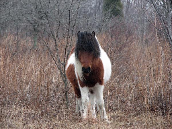
A Little Friend on Wilburn
Ridge
This Earthcache was approved by the
Geological Society of America
| We have earned GSA's highest level: |
 |
Additional Hints
(Decrypt)
Ebpx Ba!