The Alps - Cime de Caron EarthCache
-
Difficulty:
-

-
Terrain:
-

Size:  (other)
Please note Use of geocaching.com services is subject to the terms and conditions
in our disclaimer.
The Alps - Cime de Caron
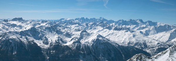
During our skiing holiday we visited this scenic view many times. From Cime de Caron you have a great view of some very high summits of the Alps. From this location you can see over 1000 summits! Here you can also find several information boards and maps about the Alps.
Easy access is possible through the skilifts Caron and Cime Caron at Val Thorens. When there are no clouds you have a fantastic view of the Mont Blanc (French for White Mountain). With its 4808 metres summit, it is the highest mountain in the Alps and Western Europe and it is ranked 11th in topographic prominence of the world.
The Alps
The Alps is the name for one of the great mountain range systems of Europe, stretching from Austria and Slovenia in the east; through Italy, Switzerland, Liechtenstein and Germany; to France in the west. The Alps are generally divided into the Western Alps and the Eastern Alps. The division is along the 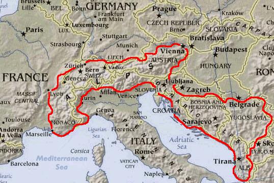
line between Lake Constance and Lake Como, following the rivers Rhine, Liro and Mera. The Western Alps are higher, but their central chain is shorter and curved; they are located in Italy, France and Switzerland. The Eastern Alps (main ridge system elongated and broad) belong to Italy, Austria, Switzerland Germany, Liechtenstein and Slovenia.
The highest peak of the Western Alps is Mont Blanc, at 4808 metres. The highest peak of the Eastern Alps is Piz Bernina, at 4049 metres. The Dufourspitze, 4634 metres and Ortler, 3905 metres, are the second-highest, respectively.
Geological features
The Alps are a complex system of lower fold mountains and high crystalline massifs. The lower mountains are largely limestone and other sedimentary rocks, while the higher peaks are composed of a crystalline, magnesium-rich rock known as dolomite. The Dolomite range in northeast Italy, with its imposing jagged pinnacles and sharp ridges, takes its name from this rock. The Alps were formed during the Oligocene and Miocene epochs as a result of pressure exerted on the Tethyan geosyncline (sedimentary deposits in the ancestral Tethys Sea), as its strata were squeezed against the stable Eurasian landmass by the northward moving African landmass. The squeezing action formed the folds (nappes) that rose out of the sea and pushed northward, often breaking and sliding one over the other to form gigantic thrust faults.
During the glaciations of the Quaternary period, huge ice masses carved out deep valley trenches, such as those of the upper Rhône, Vorderrhein, and the Inn in the Swiss Engadine. Material produced by this glacial activity was deposited as terminal moraines across rivers and streams, leading to the formation of the many lakes in the region, chief among which are Lake Geneva, Lake Constance, Lake Lucerne, and Lake Maggiore.
Several glaciers can still be seen, notably the Mer de Glâce in the Val de Chamonix below Mont Blanc, the Aar and Aletsch glaciers in Switzerland, and the Pasterze glacier in the shadow of the Grossglockner in Austria.
Many Alpine glaciers - for example, those in the Rhône valley, the Bernese Alps, and in the Swiss Grindelwald region - retreated during the 20th century, owing to a series of relatively mild winters and light snowfall.
Climate
The Alps are a classic example of what happens when a temperate area at lower altitude gives way to higher-elevation terrain. Elevations around the world which have cold climates similar to those found in polar areas have been called Alpine. A rise from sea level into the upper regions of the atmosphere causes the temperature to decrease (see adiabatic lapse rate). The effect of mountain chains on prevailing winds is to carry warm air belonging to the lower region into an upper zone, where it expands in volume at the cost of a proportionate loss of heat, often accompanied by the precipitation in the form of snow or rain.
How to log this EarthCache?
To log this EarthCache please answer these simple questions and email the answers through our profile.
1. When and how were the Alps formed?
2. What is the altitude of the information board?
3. How high is the summit of the Mont Blanc?
Also take a picture from this view point of these Alps with you, your GPSr and (part of) the information board. Add this picture to your log! (optional)
Note: Logs from teams emailing incorrect answers will be removed without further notice! If you think your answers are correct, feel free to log a 'Found'.
Additional Hints
(No hints available.)