Deze earthcache is oorspronkelijk geplaatst door GEOTROL en in September 2018 geadopteerd door Team Boon. We willen langs deze weg GEOTROL bedanken voor het vele jaren onderhouden van deze cache!
 Borgvlietse Duinen
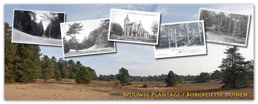
Het landgoed Wouwse Plantage is één van de mooiste stukje bosgebied van West-Brabant. Het ligt op een langgerekte zandrug die in de laatste ijstijd werd gevormd. Na die tijd begon zich het veen uit te breiden dat de bewoners van deze streek in de middeleeuwen weer hebben ontgonnen. In het midden van de 16e eeuw werden de eerste bomen aangeplant. Van oorsprong is de gehele Wouwse Plantage dus een aangeplant bos.
De ondergrond van Wouw en omgeving bestaat uit pleistocene afzettingen met een ouderdom van 10.000 tot 2,5 miljoen jaar. De afzettingen bestaan uit een afwisseling van kleiplaten en zandbanen, gedeponeerd door wind en water. Een belangrijke kleiafzetting betreft de formatie van Tegelen. Boven de klei is plaatselijk nog een jongere leemlaag aanwezig (de laag van Wouw). De afwatering via beken is over het algemeen noordwaarts gericht.
Tijdens de laatste ijstijd (ca.110.000 – 10.000 jaar geleden) werd op grote schaal dekzand afgezet, de formatie van Twente. Dit vormde ruggen in het landschap, dat daardoor een licht golvend karakter kreeg. Er ontstond een afwisseling van dekzandvlakten, welvingen en beekdalen. De dorpskern van Wouw ligt op een dekzandrug die pal noord-zuid loopt, parallel aan het beekdal van de Smalle Beek.
Vooral aan de westrand van het pleistoceen werd veel dekzand afgezet (de Brabantse Wal). Ook in het Holoceen (vanaf 10.000 jaar geleden) werd nog stuifzand afgezet op de Hoge Rand. Aan de oostzijde van de Brabantse Wal werd het zand uitgeblazen in paraboolvormige duinen; de BORGVLIETSE DUINEN!
Het gebied bestaat bijna uitsluitend uit landduinen met bijhorende vlakten en laagten. Het maximale reliëfverschil bedraagt ongeveer 8 meter. De hoogste duinen komen voor aan de oost- en noordoostkant van het gebied, waar ze een duidelijk contrast vormen met het ervoor gelegen vlakke of zwak golvende dekzandlandschap. De duinen zijn het gevolg van de historisch te intensieve landbouwpraktijken waardoor de vegetatie degradeerde en zand beschikbaar kwam voor verstuiving. Door de overheersende zuidwestenwinden werd het zand in noordoostelijke richting in duinen opgewaaid, waardoor we nu de hoogste duinen aan de oost- en noordoostkant van het gebied vinden. De zandverstuivingen werden daar vastgelegd door beplanting met een zgn. productiebos. In het gebied zijn ook nu nog kleine oppervlakten onbedekt stuifzand aanwezig.
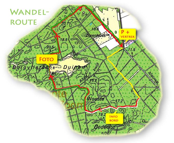
Je kunt je auto parkeren op: N 51° 28.300 en E 004° 21.755. Vanaf dat punt start de wandeling naar de twee punten die nodig zijn om deze earthcache te kunnen loggen. De wandeling is ongeveer 5 km lang en voert door een prachtig en afwisselend bosgebied. De paden zijn in principe goed begaanbaar, maar bij regen kunnen sommige stukjes wel wat modderig zijn en er zijn onderweg een paar korte stukje met los zand. LET OP: het is niet toegestaan om van de voorgeschreven wandelroute af te wijken. Anders komt de toestemming voor deze cache in gevaar!!
Vanaf de start (P) loop je via N 51° 28.232 en E 004° 21.578 (deze weg heeft de mooie naam ‘Altijd kwijt’!) naar het volgende punt: N 51° 28.044 en E 004° 21.862. Hier ga je schuin-rechts en vervolgens volg je dat pad tot N 51° 27.976 en E 004° 21.935. Hier ga je rechts-af en vanaf nu volg je de rode en de witte paaltjesroute! Je komt dan langs het infobord op N 51° 27.909 en E 004° 21.683. Hier moet je de (onderstaande) vragen beantwoorden die nodig zijn om deze earthcache te kunnen loggen. Het gebied waar je nu doorheen loopt heet overigens het ‘Woeste gedeelte’ en die naam komt door het heuvelachtige karakter. Een andere naam die vroeger werd gebruikt is ‘Klein Zwitserland’ (met de nadruk op klein!). Vervolg de route tot N 51° 27.889 en E 004° 21.361. Hier ga je weer rechts-af en vanaf nu volg je de rode en groene paaltjesroute. Na 10 min kom je bij het laatste belangrijke punt van deze route N 51° 28.182 en E 004° 20.964. Dit zijn de BORGVLIETSE DUINEN. Neem hier een foto van jezelf (of je team), mét GPS en de zandvlakte op de achtergrond. Volg hierna de rode en groene paaltjes tot het eindpunt!
Hoe kan deze earthcache gelogd worden:
Geef antwoorden op de volgende vragen en stuur ze via ons profiel bovenaan de pagina of mail ze naar gcteamboon@gmail.com. Bij goedkeuring mag er gelogd worden. Een foto is niet verplicht maar zou wel erg leuk zijn.
- Vraag 1: Hoe lang geleden is de zandrug gevormd?
- Vraag 2: Hoe groot is op dit moment het bosgebied?
- Vraag 3: Sinds wanneer is het bosgebied opengesteld?
- Optioneel: Maak een foto van tenminste één teamlid en GPS met de Borgvlietse Duinen op de achtergrond.
 Borgvlietse Dunes
The estate ‘Wouwse Plantage’ is one of the most beautiful forest area of West-Brabant. It lies on an elongated sand mountain ridge which was formed in the last ice age. After that time the peat started himself extend that the occupants of this region in the middle ages has developed. In the middle of the 16th century the first trees were planted. Of origin the whole Wouwse Plantage therefore is a planted forest.
The ground/soil of Wouw and surroundings exists from pleistocene amputations with old age of 10,000 up to 2.5 million years. Amputations exist from an alternation of clay plates and sand job, deposited by wind and water. An important clay amputation concerns the ‘formation of Tegelen’. Above clay locally a still younger layer of loam is present (south of Wouw). The drainage by means of confess generally northward has been aimed.
During the last ice age (ca.110.000 - 10,000 years suffered) on large scale sand turned off, the ‘formation of Twente’. This formed low mountain ridges in the landscape, which got as a result a slightly undulatory character. There is an alternation of sand, convexities and brook valley arose. The rural core of Wouw lies on a sand mountain ridge that runs North South, parallel to the brook valley of the ‘narrow creek’. Especially to the West edge of the pleistoceen many sand was turned off (the Brabantine rampart). Also in the Holoceen (as from 10,000 years suffered) drifting sand was still turned off on the high edge. On the East side of the Brabantine rampart sand was blown in parabolic shaped dunes; the BORGVLIETSE DUNES!
The area exists almost exclusively from country dunes with associated plains and lower parts. The maximum relief difference amounts to approximately 8 meters. The highest dunes prevent to the Easts and North East side of the area, where they form a clear contrast with the lain flat or weakly undulating sand landscape. The dunes are the consequence of the historically too intensive agriculture practices as a result of which degraded vegetation and sand came available for atomising. By predominating south west winds the sand in northeast direction in dunes was flown up, as a result of which we now find the highest dunes at the Easts and North East side of the area. Sand atomisings were as a result, fixed vegetation with so-called production forest. In the area also now still small surfaces uncovered drift-sand are present.
You can park your car on: N 51° 28.300 and E004° 21.755 . As from that point the walk starts to the two points which are necessary to log this earthcache (see 'additional waypoints' listing for the complete track!). The walk is approximately 5 km long and conducts by a splendid and alternating forest area. The paths are in principle well practicable, but at rain are possible bits some, however, what muddy to be and is there underway a couple short bit with loose sand.
PAY ATTENTION TO: it has not been permitted from the obligatory walking route deviate. Differently the authorization for these cache comes in danger!!
How can this earthcache be logged:
Give answers to the following questions and send them via our profile at the top of the page or mail them to gcteamboon@gmail.com. After our approval you can log this cache. A picture is not required but would be very nice.
- Question 1: How a long time has the sand mountain ridge been formed?
- Question 2: How large is the forest area at this moment?
- Question 3: Since when has the forest area been opened for public?
- Optional: Take a picture of at least one team member and GPS with the Borgvlietse Dunes in the background.
An Earthcache is an educational form of a virtual cache. The reward for these caches is learning more about the planet on which we live - its landscapes, its geology or the minerals and fossils that are found there. Earthcaches are developed in association with the Geological Society of America. For more information go to (www.earthcache.org)
