King Creek Falls EarthCache
-
Difficulty:
-

-
Terrain:
-

Size:  (not chosen)
Please note Use of geocaching.com services is subject to the terms and conditions
in our disclaimer.
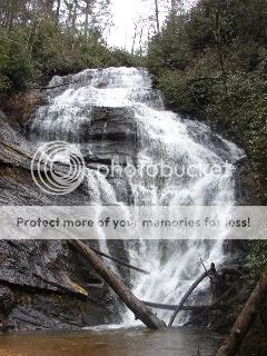
King Creek
Falls
A moderate 30 minute hike through
the Sumter National Forest will take you to the spectacular falls
of King Creek. At the base of the falls, you can relax and enjoy a
small beachy, swimming hole.

Trail Map
A waterfall is usually a geological
formation resulting from water, often in the form of a stream,
flowing over an erosion-resistant rock formation that forms a
nickpoint, or sudden break in elevation. Some waterfalls form in
mountain environments in which the erosive water force is high and
stream courses may be subject to sudden and catastrophic change. In
such cases, the waterfall may not be the end product of many years
of water action over a region, but rather the result of relatively
sudden geological processes such as landslides, faults or volcanic
action.
The story of King Creek Falls began about a billion years ago with
the collision of ancient continents to form the super continent of
Rodinia. This collision crumpled and thickened the crust burying
the rock that would become King Creek Falls some 5 miles under high
mountains. Rocks that are buried this deep are exposed to
temperatures over 1000° F and pressures over 150,000 pounds per
square inch. These temperatures and pressures cause minerals to
crystallize into layers and also to become folded or wrinkled.
These metamorphic rocks can be seen at King Creek Falls in the
different colored and folded layers of rock.
About 750 million years ago the super continent of Rodinia began
to break apart. The two main continents were formed from the
breakup, Laurentia which would later become North America and
Gondwana which would later become South America and Africa. At this
time King Creek Falls was near the southern coast of Laurentia, if
you had your GPS then you would have been at about 25° south
longitude.
About 330 million years ago Gondwana collided with Laurentria ,
this collision pushed up the deep buried metamorphic rock to form
the Appalachian Mountains. Geologists have estimated the height of
the Appalachians at this time to be an average of 26,000 feet. The
collision of Gondwana and Laurentia formed the next super continent
known as Pangea.
During the Triassic period about 220 million years ago the super
continent of Pangea began to break apart. As what happened before
with Rodinia the crust cracked and sank as it stretched apart. A
great rift basin formed north to south along what are now the east
coast of North America and the west coast of Africa. This basin has
grown 4000 miles to what is now the Atlantic Ocean.
The past 200 million years weather has eroded the Appalachian
Mountains to there present height and rounded form. Streams such as
King Creek come from springs in the higher mountains that flow into
rivers, lakes and eventually the Atlantic Ocean or the Gulf of
Mexico. As these streams flow down the mountain they encounter drop
off in the rock that create waterfalls such as King Creek Falls. So
as you look at the beauty of King Creek Falls think about the
amazing journey these rocks have taken from being buried 5 miles
deep below the earth to rise over 20,000 feet above just to be worn
down by weather and time.
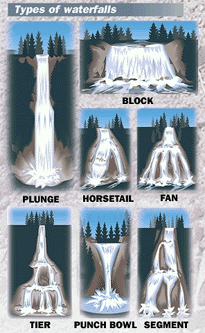
Classification
of waterfalls
Block: Water descends from a relatively wide stream
or river.
Cascade: Water descends a series of rock steps.
Cataract: A large, powerful waterfall.
Fan: Water spreads horizontally as it descends while remaining in
contact with bedrock.
Horsetail: Descending water maintains some contact with
bedrock.
Plunge: Water descends vertically, losing contact with the bedrock
surface.
Punchbowl: Water descends in a constricted form, then spreads out
in a wider pool.
Segmented: Distinctly separate flows of water form as it
descends.
Tiered: Water drops in a series of distinct steps or falls.
Multi-step: A series of waterfalls one after another of roughly
the same size each with its own sunken plunge
pool.
Logging Requirements
1 - estimate the height of King
Creek Falls
2 - What river will King Creek Falls flow into?
3 - How would you classify King Creek Falls?
4 - post a picture of you and/or GPSr taken at the falls
Waterfalls can be very dangerous
areas. Never attempt to climb a waterfall, avoid ledges, and
remember the rocks can be very slippery.
Thank-you, Mike Crane for allowing
me to develope this
earthcache!
Additional Hints
(No hints available.)