The Fox River, the third largest tributary of the Illinois River, rises in the northern part of Waukesha County, Wisconsin, enters Illinois in the northwestern corner of Lake County, and flows 115 miles south-ward to empty into the Illinois River at Ottawa.
The Fox River basin is perhaps the best place in Illinois to see evidence of glacial activity. Between 22,000 and 14,000 years ago, the Pleistocene glaciers flowed west and south across the basin from Wisconsin. These glaciers and their meltwaters forever changed the area's landscape. As the glaciers advanced repeatedly across the land, they destroyed many of the earlier stream systems by partially filling their valleys with drift. When they receded, their rapid melting gave rise to meltwater torrents that swept southward, down-cut the valleys, and eroded new river channels. The Fox River is presently located in the remnants of one of these torrent channels.
Between the Illinois-Wisconsin state line and Algonquin, Illinois, the slope of the river is very flat and the main channel of the Fox is ill- defined as it passes through a series of lakes and marshes. From Algonquin to Aurora the valley is narrow, sharply defined by bluffs, and the floodplain is either narrow or absent entirely. Below Aurora the floodplain broadens as the river begins a rapid descent to the low plain that lies on the outer border of the Marseilles moraine. It follows this moraine until it empties into the Illinois River.
Along the Fox River and many other major waterways in the U.S. are thousands of gaging stations also known as waterflow monitoring stations. The one you will see here is located in Algonquin IL where route 62 crosses the Fox.The station house is on the west bank of the river just north of 62. The United States Geological Survey (USGS) maintains and monitors these stations. Streamflow information provided by the USGS is used by many government agencies and also the National Weather service.
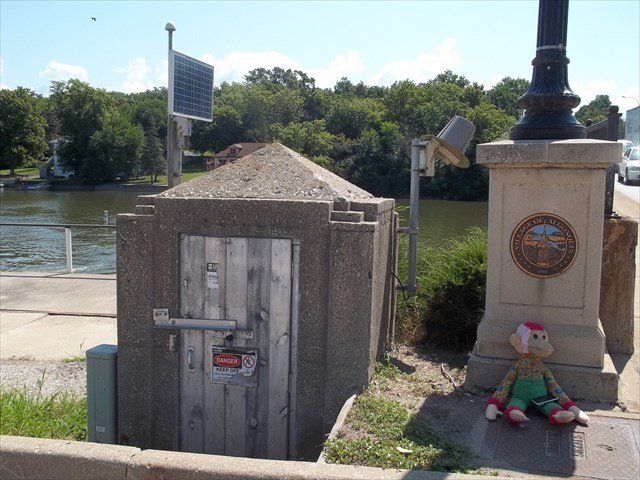
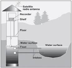
This station is a stilling well and is the type used when a gage house can be built immediately adjacent to a river. The well is connected to the stream with pipes so that when the water level in the stream changes, the water level in the well also changes. A float in the well is connected to a recorder or data-collection platform. Streamflow is also measured.
To log this cache you will need to complete the following. The answer should be e-mailed to us (via our profile) and not posted in your log. Go ahead and log your find after emailing your answer.
1. Post a picture of yourself/team on the cache page with the gage house in the background. Please try to include your face or all faces if a group photo.
2. Click here --> USGS<-- and email us the gage height of the water at the time you visited the river. Do not use the old rusty sign under the bridge.