The Collapse of Ribeira d’Ilhas
Introduction
Ribeira d’Ilhas is one of the many spectacular beaches in the west coast of Lisbon. It is located a few kilometers north of the town of Ericeira and is known worldwide for excellent surfing conditions. Many competitions on the national and international surfing calendar are successfully held there.

Geological setting
This beach hosts a group of geological phenomena and is surrounded by the "Complexo Vulcânico de Lisboa" (Lisbon Volcanic Complex) – widespread extrusion of lavas that have covered a considerable in the Lisbon region.
A traverse from south to north, beginning at the belvedere, shows a cliff face that is cut by a marked valley where the Cucos Stream flows. Further north, the Cretaceous sediments exhibit several (normal) faults many of which filled with magmatic dykes. Immediately north of the Cucos Stream there is a spectacular collapse along a set of these faults resulting from a release of strain.
Normal faults – what are they?
Normal faults generally occur in places where the lithosphere is being stretched. Consequently they are the chief structural components of many sedimentary rift basins (e.g. the North Sea) where they have major significance for hydrocarbon exploration. They can also be found in deltas, at the rear edges of huge gravitation slumps and slides. Normal faults can show diffeent geometries - and a few are shown here. In some situations the faults can become gently dipping at depth so that they have a spoon (or listric) shape. Other normal faults are found in batches, dipping in the same direction, with rotated fault blocks between. These are termed domino faults. Although most active normal faults can be shown to dip at angles steeper than 50 degrees, there are examples of very low-angle normal faults. These are often termed "detachments".
In a normal fault, the block above the fault moves down relative to the block below the fault. This fault motion is caused by tensional forces and results in extension. Other names that are sometimes used for normal faults are: normal-slip fault, tensional fault or gravity fault.
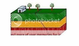
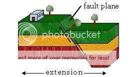
Diagram illustrating normal fault motion: On the left the yet unfaulted block; on the right the block after faulting. Note the movement of the block above the fault (the block on the right of the fault plane).
Normal faults are important because they play an important part in so many geological processes and are particularly important in petroleum exploration and extraction just to name one example: The Mesozoic geological history of the northern North Sea was dominated by extensional faulting, in addition to forming the most important hydrocarbon traps, such faults can be shown to exert a significant degree of control over the distribution of mature source rocks, and the deposition and erosion of reservoir rocks. As exploration and production have progressed the importance of small normal faults has been increasingly recognized. Although they do not totally offset reservoir formations, such small faults may provide lateral seals, thus disrupting hydrocarbon migration routes, forming subtle traps and causing technical problems during production by unanticipated compartmentalization of fields.
Low-angle normal faults (LANFs or detachment faults; dip <30°) are also globally significant; they occur in much of the geologic record, on most continents, in both extensional and contractional settings and at slow-spreading mid-ocean ridges.
The EarthCache

This Earthcache takes you to the Ribeira d'Ilhas beach setting to observe features of sediment collapse as a result of normal faulting. The mechanisms and resulting rock failure can clearly be observed on a small scale at this location. Please note that you should attempt this cache at low tide and mind the smaller geocachers as the terrain is uneven and slippery. Having said that, your log will only be validated when you you e-mail me(geo_ph@hotmail.com) the answer (with your username) to the following question:
– At the given coordinates, look east and tell me how many faults you see in the cliff face in front of you within a 10 m wide range ?
Note: Cache is best accessed during low tide conditions. Surface is slippery so be very careful when walking to the cache coordinates.
Sources: Axen, GJ, 2007. Research Focus: Significance of large-displacement, low-angle normal faults. Geology; v. 35; no. 3; p. 287-288; Hardman, R F P and Booth, JE, 1991. The significance of normal faults in the exploration and production of North Sea hydrocarbons. In:ROBERTS A. M., YIELDING, G. & FREEMAN, B. (eds), 1991, The Geometry of Normal Faults, Geological Society Special Publication No 56, pp 1-13
Fault Motion
Geologic Structures
EarthCaching: Observe, learn, enjoy and be safe!

Em Português:
A praia Ribeira d’lhas faz parte de um conjunto de praias magníficas da região Oeste de Lisboa, situada a poucos km da Ericeira. Conhecida mundialmente pela pratica de surf, mantêm ainda todos os seus aspectos naturais, onde a poluição ou a implantação humana não se faz sentir, sendo um espaço bastante tranquilo para passear. O acesso à praia é feito pelo amplo vale, que interrompe o enorme precipício, a Norte e Sul, recheado de variadíssimos fenómenos geológicos, entre os quais a nossa Falha Normal.
As Falhas, fracturas na rocha de pequena ou grande escala, estão por todo lado e resultam da compressão ou distensão de forças ocorridas na litosfera. O seu conhecimento transporta-nos não só, para a história da formação da terra, como também, abrem caminho para “tesouros” escondidos nas profundezas da terra, (extracção de mineiros, tão importante para economia e dependência humana, como o petróleo, entre outros.)
Para logar a Earthcache:
Nesta Earthcache podemos observar claramente o colapso de um bloco rochoso, proveniente de falhas normais. Com a maré baixa e ligeiramente afastados das coordenadas, observem o mecanismo que deram origem a este colapso, e tentem responder á seguinte questão, enviando as respostas para o email geo_ph@hotmail.com (com a indicação do username)
– Quantas falhas estão presentes na parede rochosa num raio de 10m das coordenadas?
(não colocar fotos reveladoras)
Nota: Ir ao local na maré baixa. Andar com cuidado, o caminho sobre a rocha poderá estar escorregadio.
Agradecimentos
Esta cache não teria sido possível sem ajuda e orientação de Daniel de Oliveira, entendido na matéria, sendo eu, apenas uma simples curiosa.
Boa Sorte
Laura Guerreiro
Nota: Esta Earthcache foi adoptada por Bargao_Henriques em 9/12/2011. This earthcache was adopt by Bargao_Henriques in 9/12/2011.