Deutsche Version:........................................................................................English Version: Click here
Die Isteiner Schwellen sind Stromschnellen im Rhein.
Sie sind ein Überbleibsel eines Ausläufers des Isteiner Klotzes, welcher ursprünglich dem Rhein den Weg in Richtung Norden versperrte und dieser zuerst durch das Rhônetal ins Mittelmeer floss.
Die Isteiner Schwellen stellten früher ein großes Hindernis für die Schifffahrt kurz unterhalb von Basel dar. Unter anderem wegen den Isteiner Schwellen wurde der Rheinseitenkanal (französisch: Grand Canal d'Alsace) von Märkt bis nach Breisach gebaut.
Der Isteiner Klotz ist 150 Mill. Jahre alter Korallenstock, entstanden im Jura-Zeitalter
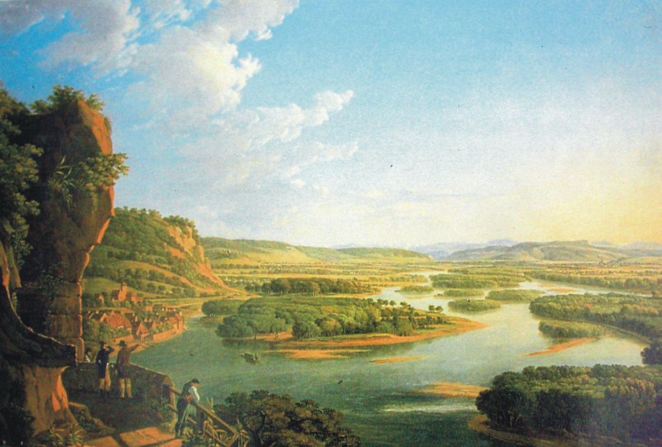
Das Bild zeigt den Blick vom Isteiner Klotz auf die Isteiner Bucht mit zahlreichen vorgelagerten Kiesinseln. Gemälde von Peter Birmann (1758 – 1844).
Von der alten Aussichtsplattform am Sporn des Isteiner Klotz blicken die Besucher in südöstlicher Richtung auf den noch weitgehend unberührten Rheinstrom. Auf der linken Seite liegt das Dorf Istein, mit hohen Ufermauern gegen den Rhein geschützt sowie ein Fischerboot am Eingang zur Isteiner Bucht direkt vor der bewaldeten Flussinsel, dem Isteiner Wörth.
Unterhalb von dieser Stelle kann man heute noch ehemalige Wasserstandmarkierungen finden, die in den Felsen gehauen wurden. Man steht sozusagen im Flussbett.
Für genauere Informationen zur Geologie des Klotzens empfehlen wir den sehr ausführlichen Artikel bei Wikipedia.
Da die Schwellen und der Klotzen zusammen gehören, müssen auch an beiden Standorten Aufgaben gelöst werden:
Parken könnt ihr bei N 47° 39.529 E 007° 31.739
An den Schwellen:
N 47° 38.838 E 007° 32.513
Gehe zu den oben angebenden Koordinaten und mache ein optionales Foto von Dir an den Isteiner Schwellen.
Beantworte folgende Frage: 1) Auf wievielen Stützen ruht die Aussichtsplattform?
Am Klotzen:
N 47° 39.677 E 007° 31.814
Ein Spaziergang flussabwärts führt Euch in die Nähe des Klotzens. Dazu geht zurück zu Eurem Fahrzeug und folgt dem Weg Richtung Sportplatz. Der Weg führt über die Straße und dann entlang des Isteiner Sportplatzes durch das kleine Wäldchen zu den Koordinaten der zweiten Aufgabe.
Dort machst Du ein optionales Foto von Dir und den markierten Pegelständen oder der St. Veits-Kapelle.
In der Nähe der Friedhofsmauer findest Du die Antworten auf die folgenden Fragen:
2) Wieviele Millionen Jahre ist die Tertiärkappe alt?
3) Wieviele Meter grub sich der Rhein ins Tal ein?
4) Wieviele Höhlen wurden ausgespült?
Es gelten die vor Ort vorhandenen Informationen.
Sende uns bitte die Antworten auf unsere Fragen an folgende Emailadresse: hegolas. Du kannst sofort loggen. Wir melden uns, wenn etwas nicht stimmt.
English Version:
The Isteiner Schwellen are rapids in the river Rhine.
They are the remains of the Isteiner Klotz, which has blocked originally the Rhine towards the north and this first flowed through the Rhone Valley into the Mediterranean.
The Isteiner Schwellen were a major obstacle to shipping briefly below Basle.
Because this and other reasons has been build the Grand Canal d'Alsace from Märkt to Breisach.
The Isteiner Klotz is 150 million year old coral floor emerged in the Jura
The picture shows the view from Isteiner Klotz on the Isteiner bay with numerous offshore islands. Paintings by Peter Birmann (1758 to 1844).
From the old viewing platform at the spur of the Isteiner Klotz, visitors can look in a south-easterly direction at the still untouched Rhine.
On the left side lies the village Istein, with high walls shoreline protected against the Rhine and a fishing boat at the entrance to the bay Isteiner front of the forested river island, the Isteiner Woerth.
Below this point, you can still find former water marks, in the rock were hewn. You stand in the river bed, so to speak.
For more detailed information on the geology of the Isteiner Klotz, we recommend the very detailed article in Wikipedia.
Because Schwellen and Klotzen belong together you have to solving tasks at both locations:
Park your car at N 47° 39.529 E 007° 31.739
At the Isteiner Schwellen:
N 47° 38.838 E 007° 32.513
Go to the above specified coordinates and make a optinal photo of yourself with the rapids.
Answer the following question: 1) On how many pillars rests the observation deck?
At the Isteiner Klotzen:
N 47° 39.677 E 007° 31.814
A walk leads you down river near the Klotzen. This goes to your vehicle pass and the subsequent divergency follows your route away from the Rhine. The route leads across the road and then along the Isteiner sports ground by the small copse to the coordinates of the second task. There are you doing a photo of you and the marked level stalls or St. Vitus chapel.
Near the cemetery wall you will find the answers to the following questions:
2) How many millions of years, the tertiary cap is old?
3) How many meters carved the Rhine into his valley?
4) How many caves have been rinsed?
The information on the spot are valid.
Send us the answers to our questions to the following email address: hegolasYou can log immediately. We'll notify you when something is wrong.