PLEASE NOTE - After heavy or prolonged
rain the little bridge at the coordinates may be under water, BUT
it is still possible to get very close to the Tree within a
Tree!!!
The Plot
The casual traveller heading north along Station Road from
Brookmans Park to Welham Green probably would hardly notice that
they had passed over Potteralls Stream flowing down the shallow
valley and draining water from the high ground of Bell Bar to the
east. The same traveller heading down Warrengate Lane, next to the
old A1, might be forgiven for assuming that the larger river to
their left was the same river or that Potteralls Stream flowed into
it. Like going through a tunnel on a train, you see something as
you enter the tunnel and then something similar when you come out
the other side, and assume that this is a continuation. However in
case it is not true!
The Mystery
The more observant would spot something strange. The Potteralls
Stream flows in a South-south-westerly direction, but the river
alongside Warrengate Lane flows northwards and is in fact a
separate river called Mimmshall Brook. So how can that be? Two
rivers flowing in opposite directions towards each other appear to
meet at a place suspiciously named "Water End". Do they come to a
sticky end? So where does the water go? The only other river close
by is the River Colne. It has its source at a spring in North Mymms
Park just 1700 metres to the west. Does the water go there?
NO!!!
Potteralls Stream and the larger Mimmshall Brook together carry
quite a high volume of water, particularly after heavy rain and ALL
that water has to go somewhere!
The Prime Suspect
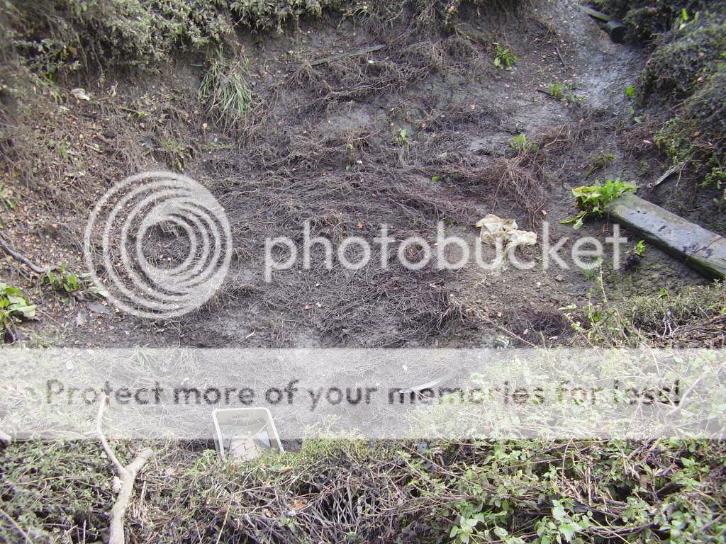
In a water meadow at Water End there are some strange things
happening. The ground is quite soft and in places very boggy. Both
rivers flow into this meadow and then disappear. The only clue is
that dotted around this meadow are funnel or bowl shaped holes -
most are small, but there are at least 15 major holes and some can
be quite large!! But big enough to swallow 2 rivers?
YES!!
These features are called Swallow Holes and the whole of this
area surrounding the holes has been designated a Site of Special
Scientific Interest (SSSI). One of these holes appeared overnight
on December 31, 1928 and was 8 metres in diameter and 15 metres
deep! During the summer, most of the meadow is covered in a thick
carpet of green vegetation and it can be difficult to see all but
the biggest of the holes. Also after heavy or prolonged rain the
volume of water flowing into the meadow is greater than the holes
can swallow or the ground can absorb and the surrounding area
floods. It is only in these circumstances that this natural basin
overflows and the excess surface water passes along a channel
through North Mimms Park, and eventually into the River Colne. In
winter when the vegetation has died back, and particularly after
light or moderate rain, it is possible to walk across the meadow
and actually see quite large streams of water disappear down these
holes into the ground.
So what do they do with the Body (of
water)!
For a long time it was thought that the water flowing into the
holes reappeared at the spring of the River Colne to the west.
However this was disproved in 1937, when researchers put
fluorescein dye into the water at one of the swallow holes,
expecting it to see it appear shortly afterwards in the River
Colne. They waited and nothing happened. Then, 3 days later, the
dyed water reappeared, nearly 16 kilometres away in the River Lea
valley at the Chadwell Springs (between Hertford & Ware)! The
mystery of the disappearing rivers had been solved!
Visiting the Cache - Logging Requirements,
Conservation and Safety
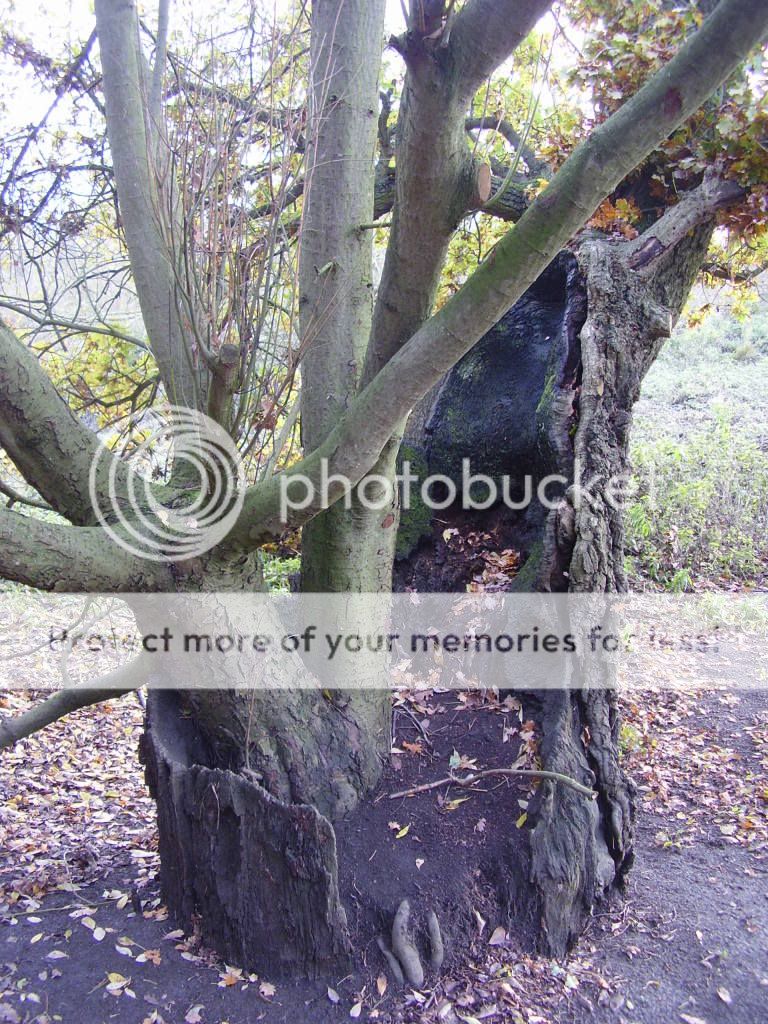
Logging Requirements - The coordinates will take you a
spot on the eastern edge of the water meadow. Nearby is a very
strange sight - one tree growing out of the centre of another. You
can't miss it and we will call it the "Tree within a Tree".
To log this cache you MUST do the following -
a) Take a picture of yourself (not just your hand!) holding your
GPS receiver standing next to the Tree within a Tree, with the
water meadow in the background.
b) Take a picture of a swallow hole (either full of water or empty)
- there are several that can be seen without leaving the public
footpath.
c) Go to the Warrengate Lane flood defences (N51° 42.829 W0°
13.220) and estimate how high the water level would have to be to
breach the flood wall.
Post both pictures to the cache webpage with your log and e-mail
the answer for c) to me (please don't put the answer for c) in your
log). Any logs not meeting these requirements will be DELETED! -
EarthCache Rules!!
Conservation and Safety The surrounding area is a Site of
Special Scientific Interest (SSSI), so please don't leave the
public footpath. The guiding principle of Earthcaches is Leave No
Trace, so please leave this important area in as good or better
condition as you find it. Unfortunately some people have dumped
rubbish and unwanted items in the area (particularly when it is
flooded) so you might want to take a rubbish sack with you and do a
little EITO (Earthcache In - Trash Out).
As with all caches near water PLEASE take great care,
particularly if you have children with you. Be careful of the
swallow holes that are close to the path, don't fall in and
especially keep your distance when the area is flooded.
Accessing the Earthcache site
The coordinates for the cache and the Tree within a Tree are on
the eastern edge of the water meadow. The shortest route to the
Earthcache site is from the west along a public footpath that
starts next to the Woodman Inn on Warrengate Lane (N51° 43.376 W0°
13.315). If the water meadow is flooded it is not possible to use
this footpath. If there hasn't been much rain and the water table
is low it is possible to walk across the water meadow on the public
footpath, but waterproof boots or wellies are advisable as it will
still be soft and boggy in parts. Alternatively from the west you
can use the public footpath, which starts by the bridge on Swanland
Road which was the old A1 (N51° 43.484 W0° 13.390). This path goes
around the northern side of the water meadow to its eastern edge
and can be used even when the water meadow is flooded. A third
route is from the east by the public footpath that starts on
Station Road, Welham Green (N51° 43.859 W0° 12.700).
The Technical Bit
The water flowing in the 2 rivers initially stays on the surface
because it is flowing over London Clay, which is fairly
impenetrable to water (it is the material which was used for the
lining of most early English canals!) However, the clay layer has
worn thin in places and at certain locations there are outcrops of
the underlying rock, which is chalk. When the river water, which is
slightly acidic flows over these chalky outcrops, it gradually
attacks small cracks in the chalk, called fissures. By a
combination of chemical and physical erosion these fissures are
enlarged becoming small underground channels and cave systems.
Rivers will always take the path of least resistance to get to
lower ground and eventually to the sea. If it becomes easier for
the river to cut a channel through the underlying chalk layer
rather than try and erode a path through the tougher more
impervious surface layer it will go underground and a swallow holes
will be formed.
 First To Find honours go to The
Bongtwashes! Congratulations Bob!
First To Find honours go to The
Bongtwashes! Congratulations Bob!