De Bertusnol
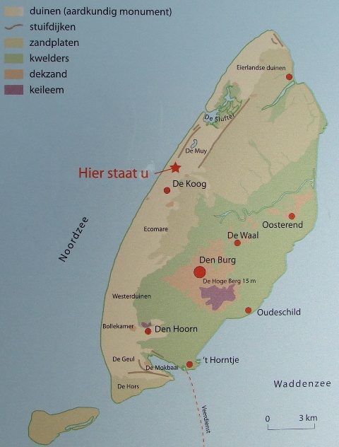
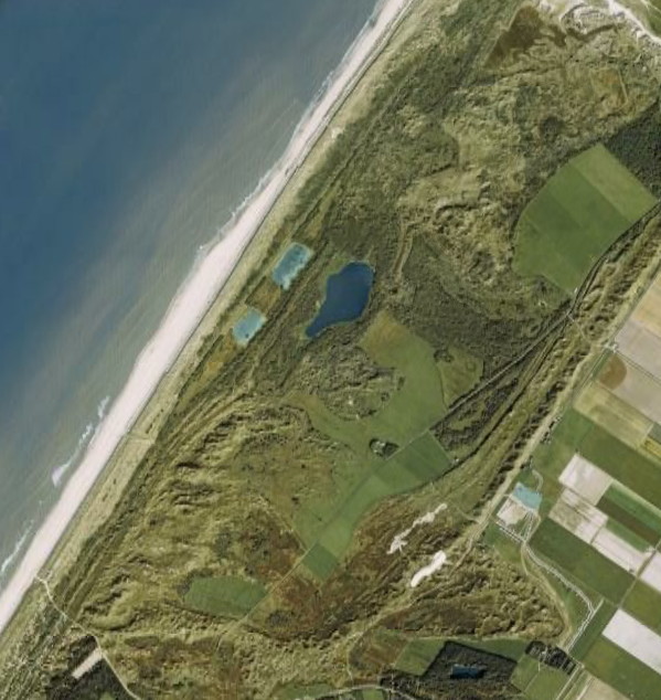
De Bertusnol is het hoogste duinpunt van Texel. Het ligt midden in het Aardkundig Monument Westelijke kuststrook van Texel . Deze brede duinstrook strekt zich uit tussen het noordelijkste puntje van Texel bij de vuurtoren van De Cocksdorp tot het zuidelijkste puntje van het eiland bij De Hors. Dit monument is één van zeventien Aardkundige Monumenten die de provincie Noord-Holland heeft aangewezen. Daarnaast maakt de kuststrook deel uit van het nationaal park Duinen van Texel , één van de twintig nationale parken van Nederland .
Texel en haar duinen
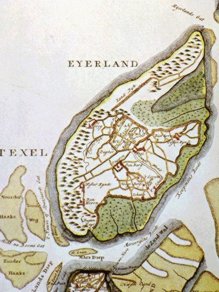
De kern van Texel bestaat uit een stabiele kleileemrug. Deze bouwde zich 130000 jaar laag voor laag onder de gletschers op. Veel later speelde de zee een belangrijke rol in de ontwikkeling van het eiland en haar duinen. In de twaalfde eeuw splitste de zee Texel in tweeën. Het gebied tussen de De Koog en Den Hoorn en ten westen van De Cocksdorp bleef droog. Hier bevinden zich de oudste en hoogste duinen van Texel. Tussen de duinen bij De Koog/Den Hoorn en het oostelijker gelegen kleileemgebied zijn de kwelders vanaf de veertiende eeuw ingepolderd. Noordelijker van Texel lag het eilandje Eierland. In 1630 zijn de twee eilanden met stuifdijken aan elkaar verbonden. Hierop ontstonden jonge duinen.
Samenspel mens en natuur
Tot aan de zeventiende eeuw kende Texel een vrij natuurlijke ontwikkeling. Daarna werd het steeds meer een samenspel tussen mens en natuur. Inwoners van Texel stimuleerden de duinontwikkeling door stuifdijken aan te leggen. De oudste is de Zanddijk uit 1630. Op de grote strandvlaktes stoof het zand tegen deze dijken en zo onstonden de relatief jonge stuifduinen. Doordat de wind hard uit één richting woei, werden soms mooie paraboolduinen gevormd. In 1858 greep de zee weer in, door enkele net aangelegde stuifdijken door te breken. Eén daarvan bleef definitief open: de Slufter.
Instructies
Om deze cache te mogen loggen moet je een aantal dingen doen.
1. Parkeer je cachemobiel op N 53 06.400 E 004 46.075. Je ijzeren ros kun je daar ook uitspannen of eventueel op N 53 06.265 E 004 46.387.
2. Loop naar de Bertusnol op N 53 06.873 E 004 46.538. Dit is een zeer fraaie wandeling door het Monument van tenminste 1 km.
3. Meet de hoogte van de Bertusnol met behulp van je GPSr of je mobiel.
4. Bereken de hoogte van de Bertusnol uitgaande van het aantal traptreden dat je net omhoog bent gelopen en de hoogte van een traptrede.
5. Stuur een e-mail naar dekokopellis@gmail.com met daarin
- de uitkomst van opdracht 3
- de berekening en uitkomst van opdracht 4
- een verklaring voor het verschil tussen de uitkomsten van opdracht 3 en 4 (N.B. We bedoelen hier niet dat je de hoogte van een traptrede niet precies genoeg kon opmeten of dat de traptreden niet allemaal evenhoog zijn).
Het is leuk als je ter plekke een foto maakt en die bij je log voegt.
Je kunt direkt loggen. We nemen contact met je op als we nog vragen hebben.
The Bertusnol
The Bertusnol is the heighest dune of the island Texel. It is located at the Geological Monument Western Coast of Texel. This broad strip of dunes runs from the most northern part of Texel near the lighthouse of De Cocksdorp until the most southern part of the island near De Hors. This monument is one of the seventeen Geological Monuments of the province Noord-Holland. The strip is also a part of the national park Dunes of Texel, one of the twenty national parks of the Netherlands.
Texel and her dunes
The centre of Texel consists of a stabile layer of clay. It was built during 130000 years, layer upon layer, below the glaciers. Much later, the sea played an important role in the development of the island and her dunes. In the twelfth century, the sea divided Texel in two parts. The area between De Koog and Den Hoorn and west of De Cocksdorp remained dry. Here you can find the highest dunes of Texel. From the fourteenth century, the part between the dunes near De Koog/Den Hoorn and the eastern part of the island were poldered. To the north of Texel, the small island Eierland was located. In 1630 the two islands have been connected by wind dikes on which young dunes were formed.
Men and nature in harmony
Until the seventeenth century, Texel was ruled by nature. Later on, it became more and more a balance between men and nature. Inhabitants of Texel stimulated the development of wind dunes by constructing wind dikes. The oldest is the Zanddijk from the year 1630. On the large sand planes, the sand blew against the dikes and young wind dunes were formed. Because the wind blew from one direction only, nice parabola dunes were formed. In 1858 the sea broke through one on the newly formed wind dikes. One remained open: the Slufter.
Instructions
To log this cache you have to do a few things.
1. Park your cachemobile at N 53 06.400 E 004 46.075. You can also park your iron horse there or possibly on N 53 06.265 E 004 46.387.
2. Walk to the Bertusnol on N 53 06.873 E 004 46.538. This is a very nice walk through the Monument of at least 1 km.
3. Measure the height of the Bertusnol using your GPSr or your mobile.
4. Calculate the height of the Bertusnol based on the number of steps you have just climbed and the height of a step.
5. Send an email to dekokopellis@gmail.com containing
- the outcome of task 3
- the calculation and outcome of task 4
- an explanation for the difference between the results of task 3 and task 4 (N.B. We do not mean here that you could not measure the height of a stair step precisely enough or that the steps are not all the same height).
It's nice if you take a picture on the spot and add it to your log.
You can log immediately. We will contact you if we have any questions.